Category:Bressay (civil parish)
Jump to navigation
Jump to search
Scottish parish covering the island of Bressay, Shetland Islands, Scotland, UK  | |||||
| Upload media | |||||
| Instance of | |||||
|---|---|---|---|---|---|
| Named after | |||||
| Location |
| ||||
| Population |
| ||||
| Area |
| ||||
 | |||||
Subcategories
This category has the following 2 subcategories, out of 2 total.
B
N
- Isle of Noss (69 F)
Media in category "Bressay (civil parish)"
The following 200 files are in this category, out of 244 total.
(previous page) (next page)-
 A Clapper Bridge - geograph.org.uk - 5288926.jpg 1,600 × 1,200; 628 KB
-
 A Mail Shot - geograph.org.uk - 2058556.jpg 2,560 × 1,920; 1.83 MB
-
 A tomb with a view - geograph.org.uk - 2707702.jpg 1,000 × 1,333; 1,007 KB
-
 Abandoned Township, Noss Sound - geograph.org.uk - 2058644.jpg 2,560 × 1,920; 1.77 MB
-
 Aith Voe - geograph.org.uk - 2060840.jpg 2,560 × 1,920; 1.97 MB
-
 Ander Hill - geograph.org.uk - 3584841.jpg 2,550 × 1,906; 1.93 MB
-
 Area around Bressay School - geograph.org.uk - 2648618.jpg 800 × 534; 167 KB
-
 Ayre of Baga, Bressay - geograph.org.uk - 5733394.jpg 1,024 × 751; 240 KB
-
 Bard Head - geograph.org.uk - 6735934.jpg 1,600 × 900; 831 KB
-
 Beach, Noss Sound - geograph.org.uk - 3809087.jpg 640 × 480; 273 KB
-
 Beosetter from the sea - geograph.org.uk - 6573258.jpg 1,600 × 1,067; 291 KB
-
 Boatman on Noss Sound - geograph.org.uk - 4311496.jpg 800 × 557; 97 KB
-
 Bogs, Clodisdale - geograph.org.uk - 3808949.jpg 640 × 480; 317 KB
-
 Bressay - Burn of Setter - geograph.org.uk - 2706753.jpg 1,394 × 1,000; 1.31 MB
-
 Bressay - Burn of Setter - Looking upstream - geograph.org.uk - 2706808.jpg 1,000 × 1,333; 1.21 MB
-
 Bressay - Burn of Setter meets the sea - geograph.org.uk - 2706813.jpg 1,333 × 1,000; 1.3 MB
-
 Bressay Aith Voe Aith Ness.jpg 640 × 485; 157 KB
-
 Bressay Aith Voe Entrance.jpg 640 × 484; 177 KB
-
 Bressay Beosetter Gunnista Road Junction.jpg 640 × 480; 64 KB
-
 Bressay Beosetter.jpg 640 × 480; 74 KB
-

-
 Bressay croftland - geograph.org.uk - 3808954.jpg 640 × 480; 259 KB
-
 Bressay Crosses St Mary's Church.jpg 480 × 640; 89 KB
-
 Bressay Ferry Gardie House.jpg 600 × 399; 43 KB
-
 Bressay Ferry Terminal, Maryfield - geograph.org.uk - 5151334.jpg 640 × 482; 288 KB
-
 Bressay fish meal and oil factory - geograph.org.uk - 3588046.jpg 640 × 480; 205 KB
-
 Bressay from the south - geograph.org.uk - 2499479.jpg 800 × 534; 129 KB
-
 Bressay Glebe.jpg 640 × 480; 68 KB
-
 Bressay Gunnista.jpg 640 × 480; 41 KB
-
 Bressay Ham.jpg 640 × 480; 70 KB
-
 Bressay Kirkabister.jpg 640 × 480; 90 KB
-
 Bressay moorland - geograph.org.uk - 3809054.jpg 640 × 480; 257 KB
-
 Bressay Ruins Aith Ness.jpg 640 × 489; 177 KB
-
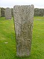
 Bressay Stone in St Mary's Walls - geograph.org.uk - 2059923.jpg 2,560 × 1,920; 1.94 MB
-
 Bressay Stone Replica - East Face - geograph.org.uk - 2059908.jpg 1,920 × 2,560; 1.76 MB
-
 Bressay Stone Replica - West Face - geograph.org.uk - 2059915.jpg 1,920 × 2,560; 1.66 MB
-
 Bressay West Ham.jpg 640 × 480; 76 KB
-
 Bressay, farm building by Noss Sound - geograph.org.uk - 2539449.jpg 640 × 480; 37 KB
-
 Bressay, Gardie House and Cottage - geograph.org.uk - 5160526.jpg 640 × 427; 371 KB
-
 Bressay, House at Ham - geograph.org.uk - 5166510.jpg 640 × 481; 348 KB
-
 Bressay, Kirkabister Ness lighthouse - geograph.org.uk - 2655917.jpg 640 × 480; 32 KB
-

-
 Bressay, lighthouse gate - geograph.org.uk - 2539446.jpg 480 × 640; 44 KB
-
 Bressay, Mail Shop - geograph.org.uk - 2655901.jpg 640 × 480; 62 KB
-
 Bressay, postbox № ZE2 90 and phone - geograph.org.uk - 2655909.jpg 640 × 480; 84 KB
-
 Bressay, road into the mist - geograph.org.uk - 2655934.jpg 640 × 480; 32 KB
-
 Bressay, telephone box at Grindiscol - geograph.org.uk - 2655911.jpg 640 × 480; 54 KB
-
-
 Bressay, theoretical view of Noss - geograph.org.uk - 2539447.jpg 640 × 480; 53 KB
-

-
 Bronze Age Reconstruction - geograph.org.uk - 2058426.jpg 1,920 × 2,560; 2.35 MB
-
 Brough, Bressay - geograph.org.uk - 2058607.jpg 2,560 × 1,920; 1.99 MB
-
 Buildings at Heogan, Bressay - geograph.org.uk - 4883117.jpg 1,024 × 681; 111 KB
-
 Churchyard and Mausoleum, Gunnista - geograph.org.uk - 2707684.jpg 1,556 × 1,000; 1.22 MB
-
 Click Mills, Cullingsburgh - geograph.org.uk - 1656586.jpg 640 × 480; 80 KB
-
 Coastal Farm, Bressay - geograph.org.uk - 5164907.jpg 640 × 427; 408 KB
-
 Coastal pasture,Bressay - geograph.org.uk - 3787583.jpg 640 × 426; 237 KB
-
 Coastguard Lookout, Ander Hill from Setter, Bressay - geograph.org.uk - 5842853.jpg 5,184 × 3,456; 4.1 MB
-
 Coastline of Bressay at Kirkabister - geograph.org.uk - 1388555.jpg 640 × 426; 48 KB
-
 Construction, Brough - geograph.org.uk - 3808906.jpg 640 × 480; 290 KB
-
 Coracle Reconstruction - geograph.org.uk - 2058462.jpg 1,920 × 2,560; 2.06 MB
-
 Crown Princess outside Lerwick - geograph.org.uk - 2712751.jpg 1,523 × 1,000; 1.06 MB
-
 Cruester Burnt Mound, Bressay - geograph.org.uk - 2058442.jpg 2,560 × 1,920; 2.4 MB
-
 Cullingsburgh - geograph.org.uk - 1544376.jpg 640 × 427; 31 KB
-
 Cullingsburgh - St Mary's and churchyard - geograph.org.uk - 2707531.jpg 1,333 × 1,000; 1.09 MB
-
 Curlew on a fencepost, Brough, Bressay - geograph.org.uk - 2257480.jpg 800 × 533; 195 KB
-
 Daal - geograph.org.uk - 3815665.jpg 640 × 480; 237 KB
-
 Dead whale in Aith Voe, Bressay - geograph.org.uk - 698184.jpg 419 × 640; 90 KB
-
 Descending Ander Hill - geograph.org.uk - 2058778.jpg 2,560 × 1,920; 1.93 MB
-
 Dunter III in Noss Sound - geograph.org.uk - 2059784.jpg 2,560 × 1,920; 1.9 MB
-
 Farm, Island of Bressay - geograph.org.uk - 2039745.jpg 640 × 480; 82 KB
-
 Ferry crossing, Noss Sound - geograph.org.uk - 2708591.jpg 1,385 × 1,000; 1.02 MB
-
 Ferry Terminal at Bressay - geograph.org.uk - 5160532.jpg 640 × 481; 474 KB
-
 Fishmeal Factory at Heogan, Bressay - geograph.org.uk - 5160242.jpg 640 × 427; 401 KB
-
 Football pitch, Bressay - geograph.org.uk - 3814862.jpg 640 × 480; 215 KB
-
 Former coastguard look-out, Ander Hill - geograph.org.uk - 2712552.jpg 1,137 × 1,000; 697 KB
-

-
 Fullaburn council houses Bressay - geograph.org.uk - 1828064.jpg 1,140 × 760; 372 KB
-

-
 Gardie House from Bressay ferry terminal - geograph.org.uk - 2713051.jpg 1,333 × 1,000; 963 KB
-
 Gardie House, Bressay - geograph.org.uk - 2058551.jpg 2,560 × 1,920; 2.16 MB
-
 Gardie House, Bressay - geograph.org.uk - 4992149.jpg 1,024 × 682; 157 KB
-
 Geo of Vatsvie - geograph.org.uk - 5828903.jpg 3,600 × 1,800; 1.98 MB
-
 Glebe and Grindiscol, Bressay - geograph.org.uk - 2499468.jpg 800 × 534; 187 KB
-
 Glebe Park, Glebe, Bressay - geograph.org.uk - 5444715.jpg 1,200 × 799; 341 KB
-
 Glebe, Bressay - geograph.org.uk - 1388579.jpg 640 × 426; 37 KB
-
 Glebe, Bressay - geograph.org.uk - 2648627.jpg 800 × 534; 148 KB
-
 Gorie Croft - geograph.org.uk - 3315116.jpg 640 × 554; 53 KB
-
 Gravestones of St Mary's, Cullingsburgh - geograph.org.uk - 2707536.jpg 1,333 × 1,000; 1.21 MB
-
 Green field below Hoversta - geograph.org.uk - 3284964.jpg 640 × 480; 71 KB
-
 Green Head, Kirkabister - geograph.org.uk - 3787566.jpg 640 × 426; 234 KB
-
 Gunnista - geograph.org.uk - 2059956.jpg 2,560 × 1,920; 1.86 MB
-
 Gunnista croftland - geograph.org.uk - 3808975.jpg 640 × 480; 266 KB
-
 Gunnista croftland - geograph.org.uk - 3809040.jpg 640 × 480; 280 KB
-
 Gunnista croftland - geograph.org.uk - 3809046.jpg 640 × 480; 243 KB
-
 Gunnista Kirkyard - geograph.org.uk - 2060856.jpg 2,560 × 1,920; 1.72 MB
-
 Gunnista Mausoleum - geograph.org.uk - 2707683.jpg 1,333 × 1,000; 1.15 MB
-
 Ham (geograph 7259141).jpg 1,024 × 770; 124 KB
-
 Ham - geograph.org.uk - 3787588.jpg 640 × 426; 251 KB
-
 Ham - geograph.org.uk - 5166527.jpg 640 × 427; 305 KB
-
 Ham, Bressay - geograph.org.uk - 1444338.jpg 640 × 426; 74 KB
-
 Ham, Bressay - geograph.org.uk - 908508.jpg 640 × 426; 37 KB
-
 Heogan Fish Factory, Bressay - geograph.org.uk - 2648604.jpg 800 × 534; 136 KB
-
 Heogan Fishmeal Factory, Bressay - geograph.org.uk - 5924962.jpg 800 × 600; 578 KB
-
 Heogan Township - geograph.org.uk - 2057272.jpg 2,560 × 1,920; 1.73 MB
-
 Hill of Cruester - geograph.org.uk - 3584720.jpg 2,560 × 1,920; 2.7 MB
-
 Hill of Setter - geograph.org.uk - 3584727.jpg 2,560 × 1,920; 3.58 MB
-
 Hillside above Grindiscol, Bressay - geograph.org.uk - 5020754.jpg 2,592 × 1,944; 1.88 MB
-
 Houllmastouri - geograph.org.uk - 2708561.jpg 1,154 × 1,000; 861 KB
-
 Houllmastouri - geograph.org.uk - 3808898.jpg 640 × 480; 252 KB
-
 House And Boat At Aith - geograph.org.uk - 3584882.jpg 2,560 × 1,920; 2.77 MB
-
 House at Cruester, Isle of Bressay - geograph.org.uk - 2039739.jpg 2,560 × 1,920; 793 KB
-
 House on the Hill above Bressay Shore - geograph.org.uk - 5160516.jpg 640 × 427; 352 KB
-
 Houses at Cruester, Island of Bressay - geograph.org.uk - 2039743.jpg 2,560 × 1,920; 910 KB
-
 I'm sure I heard a boat, dear - geograph.org.uk - 2712732.jpg 1,308 × 1,000; 1.09 MB
-
 Inside the Henderson Mausoleum at Gunnista - geograph.org.uk - 2707699.jpg 1,333 × 1,000; 1.26 MB
-
 Kirkabister - geograph.org.uk - 1571676.jpg 640 × 427; 29 KB
-
 Kirkabister Ness Lighthouse, Bressay - geograph.org.uk - 5842760.jpg 5,184 × 3,456; 5.49 MB
-
 Kirkabister, Bressay - geograph.org.uk - 2880981.jpg 800 × 532; 120 KB
-
 Leira Ness - geograph.org.uk - 6180689.jpg 1,600 × 1,067; 173 KB
-
 Lerwick from Bressay - geograph.org.uk - 2273817.jpg 6,470 × 2,743; 2.71 MB
-
 Lerwick taken from the top of the Bressay tower - geograph.org.uk - 2144063.jpg 1,600 × 1,200; 631 KB
-
 Loch of Beosetter - geograph.org.uk - 2057291.jpg 2,560 × 1,920; 1.93 MB
-
 Loch of Brough - geograph.org.uk - 3808916.jpg 640 × 480; 275 KB
-

-
 Lochs of Beosetter, Bressay - geograph.org.uk - 2039750.jpg 640 × 480; 73 KB
-
 Looking over Noss Sound to Noss - geograph.org.uk - 2708573.jpg 1,202 × 1,000; 953 KB
-
 Looking over St Mary's to Garth - geograph.org.uk - 2707622.jpg 1,549 × 1,000; 1.42 MB
-
 Mail, Bressay - geograph.org.uk - 2499475.jpg 800 × 534; 170 KB
-
 Marina at Mail, Bressay - geograph.org.uk - 2058566.jpg 2,560 × 1,920; 1.63 MB
-
 Marina, church and post office on Bressay - geograph.org.uk - 4992188.jpg 1,024 × 682; 123 KB
-
 Maryfield Pier - geograph.org.uk - 5491987.jpg 4,000 × 3,000; 5.07 MB
-
 Meadow at Gardie House - geograph.org.uk - 2057245.jpg 2,560 × 1,920; 1.72 MB
-
 Meadow, Kirkabister - geograph.org.uk - 3815667.jpg 640 × 480; 283 KB
-
 Midgarth croft house - geograph.org.uk - 1820621.jpg 1,140 × 760; 402 KB
-
 Mirki Geo - geograph.org.uk - 1846764.jpg 2,448 × 3,264; 2.87 MB
-
 Moorland, Pettifirth - geograph.org.uk - 3808969.jpg 640 × 480; 223 KB
-
 Moorland, Virdadale - geograph.org.uk - 3814874.jpg 640 × 480; 235 KB
-
 Mosaic on stones - geograph.org.uk - 2707628.jpg 1,333 × 1,000; 1.24 MB
-
 Mouth of Aith Voe - geograph.org.uk - 2060844.jpg 2,560 × 1,920; 1.76 MB
-
 Neapack of Ham, Bressay - geograph.org.uk - 2648644.jpg 800 × 535; 170 KB
-
 Nesti Voe from Ander Hill - geograph.org.uk - 2058762.jpg 2,560 × 1,920; 1.92 MB
-
 Nesti Voe, Noss - geograph.org.uk - 2058633.jpg 2,560 × 1,920; 1.88 MB
-
 Northern Slopes of Ander Hill - geograph.org.uk - 2059800.jpg 2,560 × 1,920; 1.91 MB
-
 Noss Ferry landing point on Bressay - geograph.org.uk - 3588155.jpg 640 × 480; 314 KB
-
 Noss Ferry Pier - geograph.org.uk - 2058658.jpg 2,560 × 1,920; 1.74 MB
-
 Noss Sound - geograph.org.uk - 2058696.jpg 2,560 × 1,920; 1.71 MB
-
 Noss Sound - geograph.org.uk - 2708587.jpg 1,585 × 1,000; 1.34 MB
-
 Noss Sound - geograph.org.uk - 3582993.jpg 2,560 × 1,920; 2.28 MB
-
 Noss Sound Viewpoint - geograph.org.uk - 2058615.jpg 2,560 × 1,920; 1.81 MB
-
 Noss-sound - geograph.org.uk - 3809068.jpg 640 × 480; 266 KB
-
 Noss-sound - geograph.org.uk - 3814859.jpg 640 × 480; 295 KB
-
 Noss-sound - view to Ander Hill - geograph.org.uk - 2712544.jpg 1,333 × 1,000; 1.15 MB
-
 Old croft ruins at Cullingsburgh - geograph.org.uk - 1544343.jpg 640 × 427; 32 KB
-
 Old ruins at Cullingsburgh - geograph.org.uk - 1544363.jpg 640 × 427; 48 KB
-

-
 Old water mills at Cullingsburgh - geograph.org.uk - 1544412.jpg 420 × 630; 148 KB
-
 Ordnance Survey Trig Point on Bressay, Shetland - geograph.org.uk - 5873074.jpg 2,750 × 1,821; 1.77 MB
-
 Pasture beside Noss Sound - geograph.org.uk - 3809079.jpg 640 × 480; 252 KB
-
 Pier, Maryfield - geograph.org.uk - 3815671.jpg 640 × 480; 235 KB
-
 Pier, Noss Sound - geograph.org.uk - 3809084.jpg 640 × 480; 264 KB
-
 Pierhus and Maryfield House Hotel - geograph.org.uk - 5842705.jpg 5,023 × 3,349; 4.91 MB
-
 Play area at Glebe (geograph 7259218).jpg 1,024 × 768; 115 KB
-
 Pow of Cullingsburgh - geograph.org.uk - 2706824.jpg 1,333 × 1,000; 1.05 MB
-
 Remains of broch, Noss-sound - geograph.org.uk - 2712558.jpg 1,000 × 1,333; 1.39 MB
-
 Road, Ward of Bressay - geograph.org.uk - 3814865.jpg 640 × 480; 241 KB
-
 Road, Ward of Bressay - geograph.org.uk - 3814870.jpg 640 × 480; 245 KB
-

-
 Rock Pool, Noss Sound - geograph.org.uk - 2058731.jpg 2,560 × 1,920; 1.83 MB
-
 Rocks at Loder Head - geograph.org.uk - 2059834.jpg 2,560 × 1,920; 1.69 MB
-
 Rocky Coastline, East Bressay - geograph.org.uk - 2058748.jpg 2,560 × 1,920; 1.77 MB
-
 Rocky Shore, Noss Sound - geograph.org.uk - 2058743.jpg 2,560 × 1,920; 1.81 MB
-
 Ruin across Aith Voe from Gunnista - geograph.org.uk - 2707709.jpg 1,053 × 1,000; 775 KB
-
 Ruined buildings, Cruester, Bressay - geograph.org.uk - 4992140.jpg 1,024 × 682; 186 KB
-
 Ruined cottages at Cullingsburgh - geograph.org.uk - 2707524.jpg 1,813 × 1,000; 1.27 MB
-
 Ruined croft houses and sheepfold, Noss Sound - geograph.org.uk - 2708564.jpg 1,333 × 1,000; 1.4 MB
-
 Ruined croft houses at Noss-sound - geograph.org.uk - 2708589.jpg 2,010 × 1,000; 1.53 MB
-
 Ruined Croft Houses, Daal - geograph.org.uk - 2058575.jpg 2,560 × 1,920; 1.87 MB
-
 Ruins at Daal, Bressay - geograph.org.uk - 2648659.jpg 800 × 534; 218 KB
-
 Ruins at Heogan, Bressay - geograph.org.uk - 6573226.jpg 1,600 × 1,067; 650 KB
-
 Ruins of Noss-sound - geograph.org.uk - 4311484.jpg 1,024 × 713; 168 KB
-
 Ruins of old Brough at Noss sound - geograph.org.uk - 1846744.jpg 3,264 × 2,448; 2.87 MB
-
 Ruins of St Mary's church, Cullingsburgh - geograph.org.uk - 2707527.jpg 1,333 × 1,000; 1.01 MB
-
 Ruins on the coast at Cruester, Bressay - geograph.org.uk - 2880958.jpg 800 × 532; 146 KB
-
 Rules Ness - geograph.org.uk - 2059806.jpg 2,560 × 1,920; 1.73 MB
-
 Rules Ness, Bressay - geograph.org.uk - 2059810.jpg 2,560 × 1,920; 1.74 MB
-
 Score Head - geograph.org.uk - 2077905.jpg 2,848 × 2,136; 2.8 MB
-
 Score Head - geograph.org.uk - 2077915.jpg 2,848 × 2,136; 2.82 MB
-
 Score Head, Bressay, from the sea - geograph.org.uk - 6573238.jpg 1,600 × 1,067; 362 KB
-
 Score Head, Bressay, from the sea - geograph.org.uk - 6573240.jpg 1,600 × 1,067; 334 KB
-
 Score Hill - geograph.org.uk - 3480306.jpg 2,560 × 1,920; 2.78 MB
-
 Sea Urchin by Loder Head - geograph.org.uk - 2059859.jpg 2,560 × 1,920; 1.63 MB
-
 Seat beside the Loch of Brough - geograph.org.uk - 3808919.jpg 640 × 480; 255 KB
-
 Shags at Loder Head - geograph.org.uk - 2059844.jpg 1,080 × 676; 345 KB
-
 Sheep Grazing on Loder Head - geograph.org.uk - 2059818.jpg 2,560 × 1,920; 1.66 MB
-

-
 Shoreline at Gungstie - geograph.org.uk - 2058667.jpg 2,560 × 1,920; 1.89 MB
-
 Site of ancient broch, Noss-sound - geograph.org.uk - 2712559.jpg 1,333 × 1,000; 1.27 MB
-
 Slithers on Noss Sound - geograph.org.uk - 2058685.jpg 2,560 × 1,920; 1.74 MB
-


.jpg)


.jpg)


&filefrom=South+Hill+-+geograph.org.uk+-+3815663.jpg#mw-category-media)