Category:Bridge-bunker of Hindlingen
Jump to navigation
Jump to search
Media in category "Bridge-bunker of Hindlingen"
The following 3 files are in this category, out of 3 total.
-
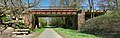 2015-04-15 10-47-54 pont-hindlingen.jpg 8,191 × 2,621; 33.29 MB
-
 2015-04-15 10-49-18 pont-hindlingen.jpg 3,645 × 2,735; 17.99 MB
-
 2015-04-15 10-50-07 pont-hindlingen.jpg 3,647 × 2,734; 13.07 MB

