Category:Brighton Main Line
Jump to navigation
Jump to search
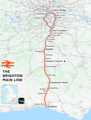
The Brighton Main Line is a major English railway line running from London Victoria and London Bridge to Brighton.
railway line between London and Brighton   | |||||
| Upload media | |||||
| Instance of |
| ||||
|---|---|---|---|---|---|
| Part of |
| ||||
| Location | London Borough of Wandsworth, Greater London, London, England | ||||
| Owned by | |||||
| Operator | |||||
| Has part(s) |
| ||||
| Date of official opening |
| ||||
| Length |
| ||||
| Terminus | |||||
| |||||
Subcategories
This category has the following 41 subcategories, out of 41 total.
A
B
- Brighton Lovers Walk TRSMD (20 F)
C
- Coulsdon North railway station (24 F)
- Coulsdon South railway station (41 F)
E
F
G
H
L
M
- Merstham railway station (48 F)
N
- Norbury railway station (39 F)
P
- Patcham Tunnel (5 F)
R
- Redhill Tunnel (1 F)
S
- South Croydon railway station (48 F)
T
- Thornton Heath railway station (40 F)
V
W
Media in category "Brighton Main Line"
The following 61 files are in this category, out of 61 total.
-
 Asylum Arch TQ2748 488.JPG 1,600 × 1,200; 492 KB
-
 Bridge carrying Dyke Road Drive over Brighton Main Line, Brighton (August 2013).JPG 2,400 × 1,800; 876 KB
-
 Brighton Line south of Gatwick - geograph.org.uk - 4297620.jpg 640 × 480; 103 KB
-
 Brighton Main Line North of Earlswood (September 2012, looking North).JPG 2,400 × 1,800; 1.28 MB
-
 Brighton main line.png 1,797 × 2,374; 4.28 MB
-

-

-

-
 Eastward view from Northbound Train near Brighton (July 2010) (1).JPG 2,500 × 1,800; 1.7 MB
-
 Eastward view from Northbound Train near Brighton (July 2010) (2).JPG 2,400 × 1,800; 977 KB
-
 Eastward view from Northbound Train near Brighton (July 2010) (3).JPG 2,592 × 1,944; 1.42 MB
-
 Eastward view from Northbound Train near Brighton (July 2010) (4).JPG 2,592 × 1,944; 1.41 MB
-
 Eastward view from Northbound Train near Brighton (July 2010) (5).JPG 2,592 × 1,944; 1.42 MB
-
 Feburary Snowday on railway tracks.jpg 1,600 × 1,200; 204 KB
-

-

-
 London MMB 18 Battersea Power Station.jpg 2,400 × 1,472; 2.39 MB
-
 London MMB C5 Brighton Main Line.jpg 3,804 × 2,262; 3.27 MB
-
 London-Brighton Line - geograph.org.uk - 1144148.jpg 640 × 435; 90 KB
-
 London-Brighton Line - geograph.org.uk - 1144156.jpg 640 × 480; 77 KB
-
 London-Brighton Line - geograph.org.uk - 537577.jpg 640 × 479; 162 KB
-

-

-
 Northward view along Brighton Main Line from Dyke Road Drive, Brighton (December 2013).JPG 3,600 × 2,600; 2.12 MB
-

-
 Northward view along London–Brighton Railway Line from Balcombe Road, Horley (June 2013) (2).JPG 2,400 × 1,800; 1,002 KB
-
-
 Northward view of Brighton Main Line from Dyke Road Drive, Brighton (September 2010) (1).JPG 2,400 × 1,600; 1,005 KB
-
 Northward view of Brighton Main Line from Dyke Road Drive, Brighton (September 2010) (2).JPG 2,500 × 1,900; 1.06 MB
-

-
 Northward view towards Industrial Estate at Balcombe Road, Horley (August 2016).JPG 2,400 × 1,600; 689 KB
-
 Old Shoreham Road Bridge - geograph.org.uk - 188130.jpg 640 × 479; 201 KB
-
 Ouse1.jpg 600 × 422; 44 KB
-

-
 Queenstown Road railway station MMB 11.jpg 3,720 × 2,248; 3.09 MB
-
 Railway Bridge at South Road, Preston Village, Brighton (January 2011).JPG 2,402 × 1,600; 856 KB
-
 Railway Track at Horley - geograph.org.uk - 201840.jpg 640 × 480; 90 KB
-
 Retaining Wall on the approach to Brighton Railway Station (April 2015) (1).jpg 3,200 × 2,200; 1.09 MB
-
 Retaining Wall on the approach to Brighton Railway Station (April 2015) (2).jpg 3,200 × 2,400; 1.32 MB
-
 Sidings North of Brighton Station (August 2016, seen from Dyke Road Drive).JPG 3,200 × 2,400; 1.47 MB
-
 Sidings North of Brighton Station (December 2013, seen from Dyke Road Drive) (1).JPG 3,600 × 2,200; 1.51 MB
-
 Sidings North of Brighton Station (December 2013, seen from Dyke Road Drive) (2).JPG 3,200 × 1,800; 1.33 MB
-
 Sidings North of Brighton Station (December 2013, seen from Dyke Road Drive) (3).JPG 3,400 × 2,000; 1.45 MB
-
 Sidings North of Brighton Station (December 2013, seen from Dyke Road Drive) (4).JPG 3,500 × 2,000; 1.29 MB
-
 Sidings North of Brighton Station (December 2013, seen from Dyke Road Drive) (5).JPG 3,500 × 2,400; 1.93 MB
-
 Southward view from Dyke Road Drive, Brighton (December 2006) (1).jpg 1,600 × 1,200; 638 KB
-
 Southward view from Dyke Road Drive, Brighton (December 2006) (2).jpg 1,600 × 1,200; 577 KB
-

-

-

-

-

-

-

-
 View from Copyhold bridge to the North - geograph.org.uk - 21590.jpg 640 × 480; 134 KB
-
 View north on the London to Brighton line - geograph.org.uk - 1748561.jpg 1,600 × 1,200; 272 KB
-

-
 View towards Brighton Railway Works from Howard Place, Brighton (December 2012).JPG 2,500 × 1,800; 1.17 MB
-
 View towards West Hill from Approaches to Brighton Station (July 2011).JPG 2,500 × 1,800; 904 KB
-

-


.JPG)

.JPG)
.JPG)
.JPG)
_(July_2009).JPG)
_(1).JPG)
_(2).JPG)
_(3).JPG)
_(4).JPG)
_(5).JPG)


_(1).JPG)
_(2).JPG)
.JPG)
_(1).JPG)
_(2).JPG)
.JPG)
_(1).JPG)
_(2).JPG)
_(3).JPG)
.JPG)


_-_geograph.org.uk_-_1498520.jpg)

.JPG)

_(1).jpg)
_(2).jpg)
.JPG)
_(1).JPG)
_(2).JPG)
_(3).JPG)
_(4).JPG)
_(5).JPG)
_(1).jpg)
_(2).jpg)
_(1).JPG)
_(2).JPG)
_(1).JPG)
_(2).JPG)
_(3).JPG)
_(4).JPG)
.jpg)


.jpg)
.JPG)
.JPG)
_-_geograph.org.uk_-_840909.jpg)
_-_geograph.org.uk_-_840922.jpg)