Category:Brookbottom
Jump to navigation
Jump to search
hamlet in New Mills parish, Derbyshire, England  | |||||
| Upload media | |||||
| Instance of | |||||
|---|---|---|---|---|---|
| Location | New Mills, High Peak, Derbyshire, East Midlands, England | ||||
 | |||||
English: Brookbottom is a hamlet about a mile outside New Mills in the High Peak borough of Derbyshire, England.
Media in category "Brookbottom"
The following 28 files are in this category, out of 28 total.
-
 Above Brook Bottom - geograph.org.uk - 4297295.jpg 1,350 × 1,800; 507 KB
-
 Approaching Brook Bottom - geograph.org.uk - 3125477.jpg 800 × 600; 136 KB
-
 Borderstone, Brook Bottom.JPG 1,200 × 800; 326 KB
-
 Brook Bottom Methodist Church - geograph.org.uk - 2833006.jpg 3,872 × 2,592; 5.19 MB
-
 Brook Bottom phone box - geograph.org.uk - 4443729.jpg 3,888 × 5,184; 6.4 MB
-
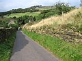 Brook Bottom Road - geograph.org.uk - 979669.jpg 640 × 480; 140 KB
-
 Byway open to all traffic near Brook Bottom - geograph.org.uk - 2827400.jpg 3,872 × 2,592; 4.89 MB
-
 Cottage adjoining rear of Fox Inn.JPG 1,200 × 1,176; 298 KB
-
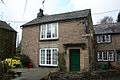
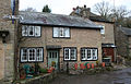
 Dwellings in Brook Bottom - geograph.org.uk - 2810770.jpg 3,296 × 2,472; 1.04 MB
-
 Footpath to Brook Bottom - geograph.org.uk - 2833000.jpg 3,872 × 2,592; 4.54 MB
-
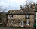 Fox Cottage, Brook Bottom.JPG 1,200 × 938; 296 KB
-
 Gilbodygate Farm, Brook Bottom - geograph.org.uk - 2928820.jpg 800 × 1,200; 178 KB
-
 Gilbodygate Farm, Brook Bottom.JPG 1,096 × 1,200; 227 KB
-
 Gilbodygate Farmhouse, Brookbottom.jpg 4,000 × 3,000; 1,016 KB
-
 High Cliff Cottage, Brookbottom.jpg 4,000 × 3,000; 1.55 MB
-
 High Cliff Farmhouse.jpg 4,000 × 3,000; 1.22 MB
-
 Minor road above Hague Bar - geograph.org.uk - 3125482.jpg 800 × 600; 112 KB
-
 Overlooking Brook Bottom - geograph.org.uk - 2810842.jpg 3,296 × 2,472; 1.12 MB
-
 Primitive Methodist School and Chapel at Brook Bottom - geograph.org.uk - 3124656.jpg 4,000 × 3,000; 2.38 MB
-
 Rivelin, Brook Bottom.JPG 1,200 × 773; 321 KB
-
 Smithy Lane out of Brook Bottom - geograph.org.uk - 4970415.jpg 640 × 480; 165 KB
-
 Tara Cottage, Brook Bottom.JPG 1,200 × 800; 343 KB
-
 The brook at Brook Bottom - geograph.org.uk - 4970480.jpg 640 × 480; 147 KB
-

-
 Track Towards Shaw Marsh - geograph.org.uk - 4259282.jpg 640 × 480; 370 KB
-
 Track, Stile and Signpost, Shaw Marsh - geograph.org.uk - 4259279.jpg 640 × 480; 345 KB
-
 View of Shaw Farm - geograph.org.uk - 1356976.jpg 640 × 480; 66 KB
-


