Category:Brugstraat 3, Grave
Jump to navigation
Jump to search
| Object location | | View all coordinates using: OpenStreetMap |
|---|
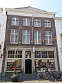
house in Grave, Netherlands  | |||||
| Upload media | |||||
| Instance of | |||||
|---|---|---|---|---|---|
| Location | Grave, Land van Cuijk, North Brabant, Netherlands | ||||
| Street address |
| ||||
| Located on street | |||||
| Heritage designation |
| ||||
 | |||||
|
This is a category about rijksmonument number 17214
|
| Address |
|
Media in category "Brugstraat 3, Grave"
The following 3 files are in this category, out of 3 total.
-
 Borstbeeld van Midas op de gevel van Brugstraat 3.jpg 3,456 × 4,608; 2.92 MB
-
 Grave - Brugstraat 3.jpg 1,944 × 2,592; 1.35 MB
-
 Overzicht - Grave - 20084021 - RCE.jpg 1,200 × 955; 249 KB

