Category:Brunnen Balthasar-Neumann-Straße (Wiesentheid)
Jump to navigation
Jump to search
This is the category of the Bavarian Baudenkmal (cultural heritage monument) with the ID D-6-75-178-10 (Wikidata)
|
| Object location | | View all coordinates using: OpenStreetMap |
|---|
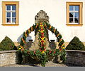
Deutsch: Brunnen. Neubarocker Brunnen als Kriegerdenkmal, bezeichnet „1870/71“. Balthasar-Neumann-Straße, am Pfarrhaus, Wiesentheid, Landkreis Kitzingen, Unterfranken, Deutschland.
cultural heritage monument D-6-75-178-10 (0) in Wiesentheid, Bavaria  | |||||
| Upload media | |||||
| Instance of | |||||
|---|---|---|---|---|---|
| Location | Wiesentheid, Kitzingen, Lower Franconia, Bavaria, Germany | ||||
| Street address |
| ||||
| Heritage designation | |||||
 | |||||
Media in category "Brunnen Balthasar-Neumann-Straße (Wiesentheid)"
The following 5 files are in this category, out of 5 total.
-
 Balthasar-Neumann-Straße, Kriegerdenkmal Wiesentheid 20200522 001.jpg 6,016 × 4,016; 13.1 MB
-
 Wiesentheid BW 2013-03-27 09-26-34.JPG 2,337 × 3,512; 4.54 MB
-
 Wiesentheid BW 2013-03-27 09-27-17.JPG 2,915 × 2,459; 3.62 MB
-
 Wiesentheid St.Mauritius Brunnen-20210228-RM-164512.jpg 3,452 × 5,184; 7.29 MB
-
 Wiesentheid, Schloßplatz 2, 003.jpg 4,928 × 3,264; 8.79 MB


