Category:Bugyal
Jump to navigation
Jump to search
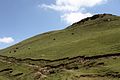
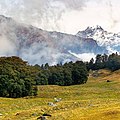
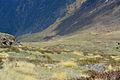
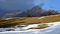
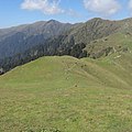
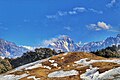
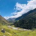
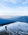
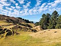
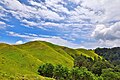
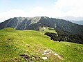
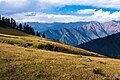
English: A Bugyal is a high altitude alpine grass lands, or meadows, in Uttarakhand, India. They are locally referred to as 'nature’s own gardens'. They can be flat or sloped, and are carpeted with green grass and seasonal flowers. These provide an excellent grazing ground and pastures for tribal herdsmen. At elevations ranging between 3300 metres and 4000 metres, these alpine meadows remain snow covered in winter. In the summer, the meadows burst into a multitude of beautiful flowers and grass. The basins of Nanda Devi, Kedarnath, Gangotri and Bandarpunch have extensive bugyals. Bugyals have very fragile ecosystems, and hence need to be carefully managed.
हिन्दी: उत्तराखण्ड के गढ़वाल हिमालय में हिमशिखरों की तलहटी में जहां टिम्बर रेखा (यानी पेडों की पंक्तियाँ) समाप्त हो जाती हैं वहां से हरे मखमली घास के मैदान आरम्भ होने लगते हैं। आमतौर पर ये ८ से १० हजार फीट की ऊँचाई पर स्थित होते हैं। गढ़वाल हिमालय में इन मैदानों को बुग्याल कहा जाता है।
high altitude location in India | |||||
| Upload media | |||||
| Location |
| ||||
|---|---|---|---|---|---|
| |||||
Subcategories
This category has the following 4 subcategories, out of 4 total.
Media in category "Bugyal"
The following 40 files are in this category, out of 40 total.
-
 Ali Bugyal.jpg 5,184 × 3,456; 14.89 MB
-
 Ali bugyal2.jpg 1,280 × 960; 342 KB
-
 Alibugyal 4440.jpg 800 × 533; 418 KB
-
 Auli Bugyal Green.jpg 1,080 × 1,080; 174 KB
-
 Auli Bugyal Himalayas.jpg 1,080 × 1,080; 328 KB
-
 Auli Bugyal Snow.jpg 1,080 × 1,080; 271 KB
-
 B (343).jpg 1,600 × 1,067; 429 KB
-
 Bagji Bugyal.jpg 1,080 × 720; 110 KB
-
 Bugyal.jpg 1,544 × 1,024; 135 KB
-
 Bugyals enroute Tungnath.jpg 1,512 × 869; 178 KB
-
 Chainsheel.jpg 1,080 × 1,080; 146 KB
-
 Chopta Bugyal.jpg 1,080 × 810; 210 KB
-
 Chopta high altitude grass lands.jpg 4,000 × 3,000; 4.43 MB
-
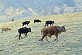 Cows roaming in alpine pastures (Bugyal) within Nanda Devi Biosphere Reserve.jpg 1,600 × 1,067; 277 KB
-
 Gorson Bugyal.jpg 1,078 × 720; 166 KB
-
 Gui (49011831947).jpg 1,802 × 1,352; 1.36 MB
-
 Har Ki Doon 10.jpg 1,080 × 810; 214 KB
-
 Har ki Doon 3.jpg 1,080 × 1,080; 234 KB
-
 Har ki Doon 9.jpg 1,080 × 1,212; 254 KB
-
 Harunta Bugyal.jpg 4,032 × 3,024; 3.83 MB
-
 Helsi Bugyal.jpg 1,080 × 795; 355 KB
-
 Kedarkantha Bugyal.jpg 1,080 × 1,350; 238 KB
-
 Khaliya Bugyal Munsiyari.jpg 1,080 × 1,350; 251 KB
-
 Kuari Pass Bugyal 2.jpg 1,080 × 810; 155 KB
-
 Kuari Pass Bugyal.jpg 1,080 × 1,080; 252 KB
-
 Kush Kalyan Bugyal.jpg 1,080 × 800; 339 KB
-
 Madhyamaheshwar Bugyal.jpg 1,080 × 1,350; 349 KB
-
 Moila Bugyal Deoban 2.jpg 1,080 × 809; 249 KB
-
 Moila Bugyal Deoban 3.jpg 1,080 × 1,080; 186 KB
-
 Moila Bugyal Deoban.jpg 1,080 × 809; 256 KB
-
 Moth Bugyal.jpg 960 × 960; 198 KB
-
 Nag Tibba Green.jpg 1,080 × 1,350; 248 KB
-
 Nawali Bugyal.jpg 1,080 × 720; 238 KB
-
 Panar Bugyal.jpg 1,080 × 1,080; 170 KB
-
 Pano baidini wikiVoyage.jpg 2,100 × 300; 154 KB
-
 Panwali Kantha 2.jpg 1,080 × 810; 150 KB
-
 Panwali Kantha.jpg 1,080 × 1,350; 125 KB
-
 Pushtara Bugyal.jpg 1,080 × 720; 265 KB
-

-
 आली बुग्याल, -- खैयुधार -- 2014-07-10 20-02.jpg 4,128 × 3,096; 4.54 MB


.jpg)


_within_Nanda_Devi_Biosphere_Reserve.jpg)

.jpg)


