Category:Buildings in Kendal
Jump to navigation
Jump to search
Subcategories
This category has the following 11 subcategories, out of 11 total.
Media in category "Buildings in Kendal"
The following 51 files are in this category, out of 51 total.
-
 31 Lowther Street - panoramio.jpg 1,728 × 3,072; 759 KB
-
 Entrance to Park - geograph.org.uk - 818087.jpg 640 × 480; 75 KB
-
 Archway - geograph.org.uk - 929388.jpg 640 × 418; 80 KB
-
 Archway - geograph.org.uk - 929390.jpg 640 × 426; 72 KB
-
 Building - geograph.org.uk - 929392.jpg 640 × 426; 76 KB
-

-
 Building in Kendal (6936).jpg 2,848 × 4,288; 5.83 MB
-
 Building next to church - geograph.org.uk - 929385.jpg 640 × 411; 102 KB
-
 Castle Crescent, Kendal - geograph.org.uk - 168341.jpg 640 × 480; 104 KB
-

-

-

-

-
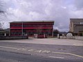
 Gilkes HQ Geograph-5918790-by-Chris-Allen.jpg 640 × 480; 97 KB
-
 Homebase Kendal - geograph.org.uk - 1613597.jpg 640 × 434; 55 KB
-
 Houses in Castle Street Kendal - geograph.org.uk - 1520371.jpg 640 × 480; 95 KB
-
 Icing on the Chocolate House - geograph.org.uk - 1630186.jpg 480 × 640; 184 KB
-
 Kendal - Branthwaite Brow - geograph.org.uk - 1758643.jpg 640 × 480; 88 KB
-
 Kendal Market Hall - panoramio.jpg 1,728 × 3,072; 1.92 MB
-
 Kendal Post Office - geograph.org.uk - 1759231.jpg 640 × 480; 118 KB
-
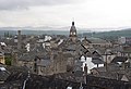
 Kendal roofscape - geograph.org.uk - 168046.jpg 640 × 459; 84 KB
-
 Kendal roofscape.jpg 629 × 429; 89 KB
-
 Kirkland, Kendal - geograph.org.uk - 929387.jpg 640 × 426; 77 KB
-
 Kirkland, Kendal - geograph.org.uk - 929408.jpg 640 × 426; 67 KB
-
 Leaving Kendal - geograph.org.uk - 148117.jpg 640 × 480; 78 KB
-
 Lowther Street, Kendal.jpg 1,600 × 1,216; 581 KB
-
 Middletons, Market Place, Kendal - geograph.org.uk - 1760156.jpg 480 × 640; 85 KB
-

-
 Museum of Lakeland Life, Abbot Hall - geograph.org.uk - 1245379.jpg 640 × 480; 66 KB
-
 Oddfellows Hall (9110305594).jpg 405 × 500; 275 KB
-
 Queen Katherine School Kendal - geograph.org.uk - 148147.jpg 640 × 480; 83 KB
-
 River Kent - geograph.org.uk - 1760193.jpg 640 × 480; 130 KB
-
 River Kent in Kendal (6938).jpg 4,288 × 2,848; 6.28 MB
-
 River Kent in Kendal (6942).jpg 4,288 × 2,848; 5.9 MB
-
 River, Kendal - geograph.org.uk - 929410.jpg 640 × 426; 106 KB
-
 Riverside houses - geograph.org.uk - 929422.jpg 640 × 350; 68 KB
-
 Sand Aire House - panoramio.jpg 3,072 × 1,728; 1.68 MB
-
 Sand Aires House, Kendal.jpg 5,184 × 3,456; 1.86 MB
-
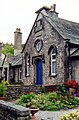 Sandes Hospital Cottages, Kendal.jpg 1,400 × 2,128; 1.06 MB
-
 Sandylands Housing Estate, Kendal - geograph.org.uk - 376109.jpg 640 × 480; 80 KB
-
 Shop, Kirkland - geograph.org.uk - 1245368.jpg 480 × 640; 85 KB
-

-
 Stramongate Former Girls School - panoramio.jpg 1,728 × 3,072; 1.82 MB
-
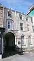
 Stricklandgate House - panoramio.jpg 3,072 × 1,728; 1.66 MB
-

-
 Tanners House - panoramio.jpg 3,072 × 1,728; 2.46 MB
-
 The Queen Katherine School - geograph.org.uk - 3473877.jpg 2,592 × 1,936; 1.01 MB
-
 The Turk - geograph.org.uk - 436178.jpg 570 × 640; 113 KB
-
 Wild Boar^ - geograph.org.uk - 436183.jpg 640 × 427; 87 KB
-
 Yard - geograph.org.uk - 929402.jpg 640 × 426; 112 KB
-
 High Tenterfell, Kendal - geograph.org.uk - 167491.jpg 640 × 480; 134 KB


.jpg)


.jpg)


.jpg)
.jpg)


