Category:Buildings in Knottingley
Jump to navigation
Jump to search
Subcategories
This category has the following 19 subcategories, out of 19 total.
- Banks in Knottingley (2 F)
*
I
K
- Kings Mill, Knottingley (13 F)
- Knottingley Fire Station (1 F)
- Knottingley Police Station (2 F)
- Knottingley Swimming Pool (2 F)
- Knottingley Town Hall (8 F)
R
Media in category "Buildings in Knottingley"
The following 17 files are in this category, out of 17 total.
-
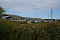 Buildings at Willow Garths - geograph.org.uk - 4118500.jpg 1,600 × 1,064; 665 KB
-
 Buildings at Willow Garths - geograph.org.uk - 4118505.jpg 1,600 × 1,064; 676 KB
-
 Cemetery chapel, Knottingley - geograph.org.uk - 5216655.jpg 1,024 × 768; 226 KB
-
 Cemetery chapel, Knottingley - geograph.org.uk - 5220906.jpg 1,024 × 768; 170 KB
-
 De Lacy Academy (geograph 3617416).jpg 1,024 × 768; 187 KB
-
 Dental Surgery - Hill Top - geograph.org.uk - 2036336.jpg 640 × 480; 70 KB
-
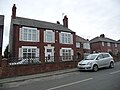
 Holly House, Knottingley.jpg 1,600 × 1,064; 550 KB
-
 Jefferson House, Womersley Road, Knottingley - geograph.org.uk - 6003329.jpg 1,600 × 1,200; 348 KB
-
-
 Knottingley Library - Hill Top - geograph.org.uk - 2036528.jpg 640 × 480; 97 KB
-
 Manor Barn off Chapel Street, Knottingley - geograph.org.uk - 4119490.jpg 1,600 × 1,064; 653 KB
-
 Path at Manor Farm, Knottingley - geograph.org.uk - 4119504.jpg 1,600 × 1,064; 625 KB
-

-
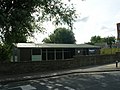
 Stolzle ^ Rockware Sports ^ Social Club - geograph.org.uk - 4119287.jpg 1,600 × 1,064; 419 KB
-
 Sue Ryder Care - Hill Top - geograph.org.uk - 2036339.jpg 640 × 480; 54 KB
-
 The Ferrybridge Progressive Club on Pottery Lane - geograph.org.uk - 4121817.jpg 1,600 × 1,064; 457 KB
-
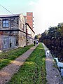 The Knottingley and Goole canal - geograph.org.uk - 5653147.jpg 3,456 × 4,608; 3.9 MB


.jpg)


