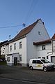
Category:Burgstraße 9 (Schloßborn)
Jump to navigation
Jump to search
| Object location | | View all coordinates using: OpenStreetMap |
|---|
This is the category of the Hessian Kulturdenkmal (cultural monument) with the ID 100189 (Wikidata)
|
| Upload media | |||||
| Instance of | |||||
|---|---|---|---|---|---|
| Location | Glashütten, Hochtaunuskreis, Darmstadt Government Region, Hesse, Germany | ||||
| Heritage designation | |||||
 | |||||
Media in category "Burgstraße 9 (Schloßborn)"
The following 2 files are in this category, out of 2 total.
-
 Schlossborn, Burgstraße 9, Scheune.JPG 4,920 × 3,240; 7.25 MB
-
 Schlossborn, Burgstraße 9.JPG 3,223 × 4,884; 5.93 MB

