Category:Burnley Road, Halifax, West Yorkshire
Jump to navigation
Jump to search
Subcategories
This category has the following 2 subcategories, out of 2 total.
P
W
- Warley Springs Garage (5 F)
Media in category "Burnley Road, Halifax, West Yorkshire"
The following 45 files are in this category, out of 45 total.
-
 A646 near King Cross - geograph.org.uk - 2684935.jpg 640 × 446; 56 KB
-
 A646 towards Halifax - geograph.org.uk - 3467743.jpg 640 × 480; 74 KB
-
 Benchmark on base stone in wall of Burnley Road - geograph.org.uk - 5800277.jpg 1,024 × 683; 316 KB
-

-

-
 Benchmark on stone in Burnley Road wall - geograph.org.uk - 5800238.jpg 1,024 × 683; 237 KB
-
 Benchmark on wall of track off Burnley Road - geograph.org.uk - 5825648.jpg 1,024 × 683; 298 KB
-

-
 Boundary stone, Burnley Road - geograph.org.uk - 3330626.jpg 2,000 × 1,423; 864 KB
-
 Boundary stone, Burnley Road - geograph.org.uk - 3330650.jpg 2,145 × 2,124; 1.43 MB
-
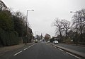
 Burnley Road (A646) - geograph.org.uk - 3467736.jpg 640 × 480; 69 KB
-
 Burnley Road (A646), Halifax - geograph.org.uk - 2053099.jpg 800 × 600; 227 KB
-
 Burnley Road (A646), Warley, Halifax - geograph.org.uk - 2053079.jpg 800 × 600; 249 KB
-

-

-

-

-

-
 Burnley Road A646, Halifax - geograph.org.uk - 991846.jpg 640 × 480; 84 KB
-
 Burnley Road houses at junction with side road - geograph.org.uk - 5827082.jpg 1,024 × 683; 225 KB
-
 Burnley Road houses at Willow Drive junction - geograph.org.uk - 5827011.jpg 1,024 × 683; 174 KB
-
 Burnley Road, A646 - geograph.org.uk - 2684920.jpg 1,024 × 768; 187 KB
-
 Burnley Road, Warley - geograph.org.uk - 2053084.jpg 800 × 600; 230 KB
-
 Cottages - Burnley Road - geograph.org.uk - 909762.jpg 640 × 617; 401 KB
-

-
 Defaced boundary stone beside Burnley Road - geograph.org.uk - 5801333.jpg 683 × 1,024; 218 KB
-
 Entrance to Woodcroft Grange from Burnley Road - geograph.org.uk - 5827102.jpg 1,024 × 683; 275 KB
-
 Granny Hill - geograph.org.uk - 1845894.jpg 480 × 640; 139 KB
-

-
 Jet Filling Station - Burnley Road - geograph.org.uk - 909768.jpg 640 × 443; 239 KB
-
 King Cross Garage - geograph.org.uk - 3467742.jpg 640 × 480; 76 KB
-
 Milestone (2539057603).jpg 2,293 × 1,784; 2.9 MB
-
 Milestone, Burnley Road A646, Halifax - geograph.org.uk - 991855.jpg 497 × 640; 86 KB
-

-
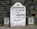
 Old Milestone by the A646, Skircoat, Halifax (geograph 6044262).jpg 480 × 640; 368 KB
-
 Old water main valve marker plate, Burnley Road - geograph.org.uk - 3330657.jpg 2,000 × 1,508; 922 KB
-
 Old water main valve marker plate, Burnley Road - geograph.org.uk - 3330669.jpg 2,250 × 2,070; 1.05 MB
-

-
 Steps down from Burnley Road towards Rochdale Road - geograph.org.uk - 3841940.jpg 3,672 × 4,896; 3.06 MB
-
 Stone wall beside Burnley Road - geograph.org.uk - 5800378.jpg 1,024 × 683; 208 KB
-
 Stone wall on NE side of Burnley Road - geograph.org.uk - 5800263.jpg 1,024 × 683; 204 KB
-
 The Allan Fold, Burnley Road, Halifax - geograph.org.uk - 991415.jpg 640 × 468; 65 KB
-

-
 Timmey Lane and Burnley Road - geograph.org.uk - 1479643.jpg 640 × 480; 84 KB
-
 Twin Flight of steps in Burnley Road (A646) - geograph.org.uk - 3841947.jpg 3,484 × 2,681; 2.29 MB


_-_geograph.org.uk_-_5826976.jpg)


_-_geograph.org.uk_-_3467736.jpg)
,_Halifax_-_geograph.org.uk_-_2053099.jpg)
,_Warley,_Halifax_-_geograph.org.uk_-_2053079.jpg)


.jpg)


.jpg)


_-_geograph.org.uk_-_3841947.jpg)