Category:Burrill with Cowling
Jump to navigation
Jump to search
civil parish in North Yorkshire, England  | |||||
| Upload media | |||||
| Instance of | |||||
|---|---|---|---|---|---|
| Named after | |||||
| Location | Hambleton, North Yorkshire, Yorkshire and the Humber, England | ||||
| Population |
| ||||
| Area |
| ||||
 | |||||
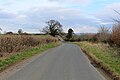
English: Burrill with Cowling is a civil parish in the Hambleton district of North Yorkshire, England, including the villages of Burrill and Cowling. According to the 2001 census it had a population of 81.
Media in category "Burrill with Cowling"
The following 55 files are in this category, out of 55 total.
-

-
 Barn at High Pond House Farm - geograph.org.uk - 6567780.jpg 2,019 × 1,465; 969 KB
-
 Benchmark on barn at Low Cowling - geograph.org.uk - 5131295.jpg 683 × 1,024; 221 KB
-
 Benchmark on Burrill Mission Church - geograph.org.uk - 4713843.jpg 683 × 1,024; 288 KB
-
 Benchmark on gatepost beside Cowling Lane - geograph.org.uk - 4714153.jpg 683 × 1,024; 252 KB
-
 Benchmark on High Pond Farm Barn - geograph.org.uk - 6567785.jpg 1,800 × 2,369; 2.2 MB
-
 Burrill - geograph.org.uk - 4876392.jpg 1,600 × 1,067; 755 KB
-
 Burrill Lane - geograph.org.uk - 2396878.jpg 3,264 × 2,448; 1.78 MB
-
 Burrill Mission Church - geograph.org.uk - 4713860.jpg 1,024 × 683; 195 KB
-
 Burrill Mission Church - geograph.org.uk - 4876394.jpg 1,600 × 1,067; 590 KB
-
 Burrill Mission Church - geograph.org.uk - 6593103.jpg 1,024 × 863; 211 KB
-
 Burrill Mission Church on Cowling Road, Burrill - geograph.org.uk - 4695255.jpg 1,600 × 1,065; 793 KB
-
 Burrill Road - geograph.org.uk - 4876362.jpg 1,600 × 1,067; 479 KB
-
 Burrill Road - geograph.org.uk - 6593092.jpg 800 × 600; 138 KB
-
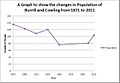 Burrill with Cowling time series 1871-2011.jpg 641 × 446; 52 KB
-
 Cereal crop, Thornton Watlass Estate - geograph.org.uk - 6593117.jpg 1,024 × 768; 170 KB
-
 Cottages on Cowling Road, Burrill - geograph.org.uk - 6596584.jpg 4,438 × 3,196; 2.42 MB
-
 Cowling - geograph.org.uk - 6492564.jpg 4,979 × 3,623; 4.01 MB
-
 Cowling Lane - geograph.org.uk - 4876391.jpg 1,600 × 1,067; 656 KB
-
 Cowling Lane at Cowling Plantation - geograph.org.uk - 4714171.jpg 1,024 × 683; 285 KB
-
 Cowling Lane at Park Hill - geograph.org.uk - 5131282.jpg 1,024 × 683; 199 KB
-
 Cowling Road, Burrill - geograph.org.uk - 6593099.jpg 1,024 × 768; 180 KB
-
 Cowling Whins - geograph.org.uk - 4876400.jpg 1,600 × 1,067; 478 KB
-

-
 Elizabeth II postbox on Cowling Road, Burrill - geograph.org.uk - 6596577.jpg 2,740 × 4,036; 2.66 MB
-
 Farm buildings at Low Cowling, Cowling Lane - geograph.org.uk - 5131318.jpg 1,024 × 666; 174 KB
-
 Farm buildings on Cowling Road, Burrill - geograph.org.uk - 6593095.jpg 1,024 × 658; 148 KB
-
 Farm on Cowling Road, Burrill - geograph.org.uk - 4695171.jpg 1,600 × 1,065; 981 KB
-
 Farm on Cowling Road, Burrill - geograph.org.uk - 4695178.jpg 1,600 × 1,065; 669 KB
-
 Farm Outbuilding off Moor End Lane - geograph.org.uk - 5563896.jpg 5,069 × 3,422; 6.71 MB
-
 Farm track beside Rand Hill Plantation - geograph.org.uk - 6593106.jpg 1,024 × 768; 195 KB
-
 Field entrance and barn off Moor End Lane - geograph.org.uk - 6698345.jpg 1,024 × 768; 180 KB
-
 Field Track leading to Burrill Beck - geograph.org.uk - 4876369.jpg 1,600 × 1,067; 739 KB
-
 Footpath to Burrill - geograph.org.uk - 2396887.jpg 2,448 × 3,264; 2.95 MB
-
 Former Methodist Chapel on Cowling Road - geograph.org.uk - 4695162.jpg 1,600 × 1,065; 658 KB
-
 Gated track, Thornton Watlass Estate - geograph.org.uk - 6593115.jpg 1,024 × 768; 370 KB
-
 Harvested field, Cowling - geograph.org.uk - 2589298.jpg 2,673 × 1,632; 910 KB
-
 High Lane - geograph.org.uk - 2396903.jpg 3,264 × 2,448; 2.58 MB
-
 High Lane - geograph.org.uk - 5563872.jpg 5,184 × 3,456; 6.6 MB
-
 High Pond House - geograph.org.uk - 2294819.jpg 1,024 × 768; 128 KB
-
 Hillside field near Bedale Wood Farm - geograph.org.uk - 6593090.jpg 800 × 600; 124 KB
-
 House on Cowling Road, Burrill - geograph.org.uk - 6593097.jpg 1,024 × 768; 202 KB
-
 Jubilee Bridge for road into Burrill - geograph.org.uk - 5132175.jpg 1,024 × 683; 219 KB
-
 Junction ahead - geograph.org.uk - 6492560.jpg 5,184 × 3,888; 7.31 MB
-
 Junction on Burrill Road, North Yorkshire.jpg 1,024 × 768; 219 KB
-
 Minor road towards Thornton Watlass - geograph.org.uk - 6593108.jpg 1,024 × 768; 147 KB
-
 Minor road towards Thornton Watlass - geograph.org.uk - 6593122.jpg 640 × 480; 63 KB
-
 Old Covert - geograph.org.uk - 5563875.jpg 5,184 × 3,456; 6.36 MB
-
 The former Police House, Burrill - geograph.org.uk - 4695248.jpg 1,600 × 1,065; 722 KB
-
 Towards High Pond House - geograph.org.uk - 2396911.jpg 2,367 × 1,632; 836 KB
-
 Track through farmland within Burrill - geograph.org.uk - 5132163.jpg 1,024 × 683; 228 KB
-
 Village street, Burrill - geograph.org.uk - 6492565.jpg 5,184 × 3,888; 6.26 MB
-
 Winter tree green with ivy - geograph.org.uk - 2294827.jpg 1,024 × 768; 101 KB
-
 Winter tree in arable field - geograph.org.uk - 2294828.jpg 1,024 × 768; 114 KB
-
 Winter trees, eastern end of Stubbing Nook Lane - geograph.org.uk - 5699120.jpg 1,024 × 768; 190 KB


