Category:Byer Covered Bridge
Jump to navigation
Jump to search
| Object location | | View all coordinates using: OpenStreetMap |
|---|
|
This is a category about a place or building that is listed on the National Register of Historic Places in the United States of America. Its reference number is 75001441. |
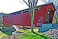
covered bridge in Washington Township, Jackson County, Ohio  | |||||
| Upload media | |||||
| Instance of | |||||
|---|---|---|---|---|---|
| Located in protected area | |||||
| Location | Byer, Ohio | ||||
| Heritage designation |
| ||||
 | |||||
Media in category "Byer Covered Bridge"
The following 4 files are in this category, out of 4 total.
-
 Bridge Over Green Water (122707212).jpg 900 × 602; 311 KB
-
 Byer Covered Bridge (122170889).jpg 1,022 × 681; 444 KB
-
 Byer Covered Bridge from north.jpg 6,016 × 4,000; 6.48 MB
-
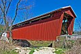 Byer Covered Bridge-2 (122530182).jpg 1,024 × 683; 374 KB
.jpg)
.jpg)
.jpg)