Category:Byker Bridge
Jump to navigation
Jump to search
| Object location | | View all coordinates using: OpenStreetMap |
|---|
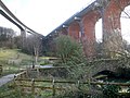
English: The Byker Bridge is a 344.65m long road bridge that carries the A193 road over the River Ouseburn in Newcastle upon Tyne. It carries traffic from the city centre and Central Motorway in the west, to the area of Byker to the east, over the lower Ouseburn valley, with the river emptying into the north side of the River Tyne, around 500m to the south.
Opened in 19th October 1878, it was widened from 9.15m to 15.25m in 1899, while the bridge deck was rebuilt in 1985-6.
It is one of three high level bridges in close proximity making the same crossing, with the Byker Metro Bridge and then the Ouseburn railway Viaduct both to the north (the S shaped Metro bridge crosses over the road bridge at its eastern end).
road bridge in Newcastle upon Tyne, Tyne and Wear, England  | |||||
| Upload media | |||||
| Instance of | |||||
|---|---|---|---|---|---|
| Location | Byker, Newcastle upon Tyne, Northumberland, North East England, England | ||||
| Crosses | |||||
 | |||||
Media in category "Byker Bridge"
The following 16 files are in this category, out of 16 total.
-
 Bridges from the Ouseburn Valley - geograph.org.uk - 1064931.jpg 480 × 640; 135 KB
-
 Byker Bridge - geograph.org.uk - 71215.jpg 640 × 480; 53 KB
-
 Byker Bridge Walkway - geograph.org.uk - 197625.jpg 640 × 480; 65 KB
-
 Byker Road Bridge - geograph.org.uk - 1775124.jpg 1,024 × 768; 257 KB
-
 Crawford's Bridge, Ouseburn - geograph.org.uk - 1775388.jpg 640 × 480; 85 KB
-
 Ford, Ouseburn - geograph.org.uk - 1777712.jpg 1,024 × 768; 261 KB
-
 Ouseburn and viaducs, Newcastle-1.jpg 2,368 × 3,552; 1.9 MB
-

-

-

-
 Ouseburn Farm and the bridges - geograph.org.uk - 1777725.jpg 1,024 × 769; 346 KB
-
 Ouseburn farm and viaduct.jpg 2,368 × 3,552; 2.03 MB
-
 Ouseburn farm.jpg 3,409 × 2,368; 2.03 MB
-
 Ouseburn panorama - geograph.org.uk - 1777719.jpg 3,000 × 1,269; 1.13 MB
-
 Ouseburn view.jpg 3,552 × 2,368; 1.96 MB
-


_-_geograph.org.uk_-_1528547.jpg)


