Category:Cadeby, South Yorkshire
Jump to navigation
Jump to search
English: Cadeby is a village and civil parish in the Metropolitan Borough of Doncaster in South Yorkshire, England. It is about five miles west of Doncaster, and four miles east of Mexborough.
Nederlands: Cadeby is een dorp (village) en civil parish in het bestuurlijke gebied Doncaster, in het Engelse graafschap South Yorkshire. De civil parish telt
village in South Yorkshire, England, United Kingdom  | |||||
| Upload media | |||||
| Instance of | |||||
|---|---|---|---|---|---|
| Location | Doncaster, South Yorkshire, Yorkshire and the Humber, England | ||||
 | |||||
Subcategories
This category has the following 2 subcategories, out of 2 total.
C
- Conisbrough Viaduct (20 F)
Media in category "Cadeby, South Yorkshire"
The following 66 files are in this category, out of 66 total.
-
 Beer garden of the Cadeby inn. - geograph.org.uk - 4696781.jpg 640 × 480; 95 KB
-
 Cadeby - geograph.org.uk - 116944.jpg 640 × 480; 91 KB
-
 Cadeby - Pasture Lane.jpg 640 × 427; 66 KB
-
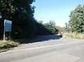
 Cadeby Lane towards Cadeby - geograph.org.uk - 116934.jpg 640 × 476; 78 KB
-
 Cadeby quarry viewed from Conisbrough viaduct - geograph.org.uk - 4179803.jpg 1,024 × 768; 175 KB
-
 Cadeby Tunnel - geograph.org.uk - 863965.jpg 640 × 480; 172 KB
-
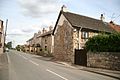
 Cadeby Village - geograph.org.uk - 1382919.jpg 640 × 480; 67 KB
-
 Carr at the western end of Sprotbrough Flash - geograph.org.uk - 3339190.jpg 1,024 × 768; 229 KB
-
 Conibrough Viaduct trail - geograph.org.uk - 4179806.jpg 1,024 × 768; 203 KB
-
 Conisbrough - Rainbow Bridge.JPG 1,704 × 2,272; 1.28 MB
-
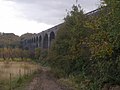
 Conisbrough Viaduct - geograph.org.uk - 2690844.jpg 1,024 × 768; 219 KB
-
 Conisbrough Viaduct - geograph.org.uk - 3212620.jpg 2,048 × 1,536; 567 KB
-
 Conisbrough Viaduct - geograph.org.uk - 5839050.jpg 1,024 × 683; 167 KB
-
 Conisbrough Viaduct from Conisbrough Castle Keep - geograph.org.uk - 6016235.jpg 1,600 × 1,200; 355 KB
-
 Conisbrough viaduct from the Trans Pennine Trail - geograph.org.uk - 4786793.jpg 1,024 × 768; 198 KB
-
 Conisbrough Viaduct through the trees - geograph.org.uk - 2747485.jpg 640 × 480; 114 KB
-
 Constitution Hill Bridge - geograph.org.uk - 925885.jpg 640 × 427; 78 KB
-

-

-
 Dolomite Quarry - geograph.org.uk - 925492.jpg 640 × 427; 71 KB
-
 Don Valley - geograph.org.uk - 925581.jpg 640 × 427; 84 KB
-
 Don Valley view - geograph.org.uk - 925594.jpg 640 × 427; 69 KB
-
 English Heritage's Conisbrough Castle - geograph.org.uk - 4179805.jpg 1,024 × 768; 185 KB
-

-
 Farmland at the edge of Pot Ridings Wood - geograph.org.uk - 3339187.jpg 1,024 × 768; 143 KB
-
 Farmland near Cadeby - geograph.org.uk - 2425736.jpg 1,600 × 1,200; 372 KB
-
 Field between Pasture Lane and Cliff Wood - geograph.org.uk - 5730499.jpg 1,024 × 768; 181 KB
-
 Field Boundary and woods beyond - geograph.org.uk - 116931.jpg 640 × 480; 127 KB
-
 Fields and Woodland near Cadeby - geograph.org.uk - 5097014.jpg 4,608 × 3,456; 4.36 MB
-
 Fields near Cadeby - geograph.org.uk - 5097019.jpg 4,608 × 3,456; 4.37 MB
-
 Footpath alongside Cadeby Road - geograph.org.uk - 5731317.jpg 1,024 × 768; 226 KB
-
 Grey Stones, Pot Ridings Wood, Sprotbrough Gorge - geograph.org.uk - 3339197.jpg 1,024 × 768; 300 KB
-
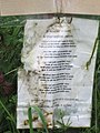
 In Memory of Cory, Conisbrough Viaduct - geograph.org.uk - 2953010.jpg 600 × 800; 219 KB
-
 In Memory of Cory, Conisbrough Viaduct - geograph.org.uk - 2953011.jpg 600 × 800; 118 KB
-
 Landfill Site Entrance on Cadeby Lane - geograph.org.uk - 5097035.jpg 4,534 × 3,353; 3.25 MB
-
 Lane to Cadeby. - geograph.org.uk - 1730858.jpg 480 × 640; 131 KB
-
 Lane towards Cadeby - geograph.org.uk - 3212601.jpg 2,048 × 1,536; 526 KB
-
 Narrow boat on the River Don - geograph.org.uk - 3212653.jpg 2,048 × 1,536; 512 KB
-
 Quarry buildings - geograph.org.uk - 1743055.jpg 640 × 480; 65 KB
-
 Quarry Road - geograph.org.uk - 925842.jpg 640 × 427; 82 KB
-
 Railway Bridge over River Don - geograph.org.uk - 2388212.jpg 3,264 × 2,448; 2.42 MB
-
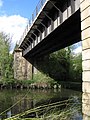
 Rainbow Rail Bridge over the River Don - geograph.org.uk - 4006313.jpg 1,600 × 1,064; 709 KB
-
 Road Closed - geograph.org.uk - 925838.jpg 640 × 427; 79 KB
-

-
 The Cadeby Inn - geograph.org.uk - 2425738.jpg 1,600 × 1,200; 535 KB
-

-
 The entrance to Sprotbrough Flash Nature Reserve - geograph.org.uk - 4006303.jpg 1,600 × 1,064; 778 KB
-
 The Footpath to High Melton. - geograph.org.uk - 4727720.jpg 640 × 480; 38 KB
-
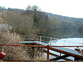
 The navigable River Don - geograph.org.uk - 4179810.jpg 1,024 × 768; 214 KB
-
 The River Don - geograph.org.uk - 116970.jpg 640 × 480; 115 KB
-
 The River Don - geograph.org.uk - 2690850.jpg 1,024 × 768; 307 KB
-
 The River Don from Conisbrough Viaduct - geograph.org.uk - 3213215.jpg 2,048 × 1,536; 604 KB
-

-
 The Road to Cadeby - geograph.org.uk - 2689806.jpg 1,024 × 768; 232 KB
-
 The road to Cadeby Quarry - geograph.org.uk - 116948.jpg 640 × 480; 86 KB
-
 The Trans Pennine Trail near Denaby Ings - geograph.org.uk - 5097002.jpg 4,608 × 3,456; 4.4 MB
-
 Trans Pennine Trail at Conisbrough Viaduct - geograph.org.uk - 4006340.jpg 1,600 × 1,064; 784 KB
-
 Trans Pennine Trail at Conisbrough Viaduct - geograph.org.uk - 4006418.jpg 1,600 × 1,064; 799 KB
-
 Trans Pennine Trail near Constitution Hill - geograph.org.uk - 4006432.jpg 1,600 × 1,064; 612 KB
-
 Trans Pennine Trail towards Denaby Ings - geograph.org.uk - 4006459.jpg 1,600 × 1,064; 824 KB
-
 Viaduct and beyond. - geograph.org.uk - 1657155.jpg 640 × 480; 48 KB
-
 Wheatfield and Scabba Wood - geograph.org.uk - 5731319.jpg 1,024 × 768; 150 KB
-
 White House Farm - geograph.org.uk - 929710.jpg 640 × 427; 64 KB
-
 White House Farm building - geograph.org.uk - 929715.jpg 640 × 427; 68 KB
-
 Works yard - geograph.org.uk - 925974.jpg 640 × 427; 97 KB
-
 Yew in Pot Ridings Wood - geograph.org.uk - 3339180.jpg 1,024 × 768; 275 KB


