Category:Cairns in Dumfries and Galloway
Jump to navigation
Jump to search
Subcategories
This category has the following 37 subcategories, out of 37 total.
A
- Andrewhinney Hill summit (3 F)
B
- Beninner summit (2 F)
- Benyellary summit cairn (5 F)
- Black Cairn, Auchenmalg (1 F)
- Bodesbeck Law summit (2 F)
- Burnswark Hill (12 F)
C
- Cairn Holy Chambered Cairns (31 F)
- Cairn Na Gath, New Luce (3 F)
- Cairn Pat fort, Portpatrick (7 F)
- Cairnhead fort, Whithorn (8 F)
- Cairnsgarroch summit (2 F)
- Carlin's Cairn summit (2 F)
- Carrifran Gans summit cairn (3 F)
- Caves of Kilhern, New Luce (3 F)
- Coran of Portmark summit (2 F)
- Corserine summit (5 F)
- Craignaw - Craignairny cairn (2 F)
E
- Ettrick Pen summit (5 F)
F
- Firthhope Rig summit (3 F)
H
- High Gillespie cairn (2 F)
L
- Little Spear summit (2 F)
M
- Mid Gleniron cairns (1 F)
- Millfire summit (4 F)
- Millfore summit (3 F)
S
- South cairn, Queensberry (2 F)
T
- Trowgrain Middle summit (2 F)
W
- White Coomb summit (4 F)
Media in category "Cairns in Dumfries and Galloway"
The following 200 files are in this category, out of 342 total.
(previous page) (next page)-
 A cairn at the site of St Conal's Church - geograph.org.uk - 1518505.jpg 640 × 427; 133 KB
-
 A cairn near the summit of Cairngarroch - geograph.org.uk - 516687.jpg 640 × 480; 111 KB
-
 A cairn on Arkleton Hill - geograph.org.uk - 328304.jpg 640 × 480; 78 KB
-
 A Cairn on the Tors of Glenmalloch - geograph.org.uk - 503434.jpg 640 × 480; 101 KB
-
 A cairn on Wether Law - geograph.org.uk - 736342.jpg 640 × 480; 113 KB
-
 A curious pile of rocks - geograph.org.uk - 486375.jpg 640 × 480; 84 KB
-
-
 A wee marker Cairn beside the footpath - geograph.org.uk - 526459.jpg 640 × 480; 149 KB
-

-
 Barlaes Cairn - geograph.org.uk - 998858.jpg 640 × 480; 76 KB
-
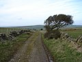
 Barraer farm road - geograph.org.uk - 499790.jpg 640 × 480; 153 KB
-
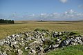
 Barvennan Moss - geograph.org.uk - 679504.jpg 640 × 480; 112 KB
-
 Beeches at 'Oaks of Kirkconnell' - geograph.org.uk - 75017.jpg 640 × 480; 189 KB
-
 Beneraird Summit - geograph.org.uk - 709357.jpg 640 × 479; 61 KB
-
 Beneraird Summit - geograph.org.uk - 714047.jpg 640 × 479; 106 KB
-
 Bennan Hill Cairn - geograph.org.uk - 354525.jpg 640 × 480; 45 KB
-

-
 Beoch Hill - geograph.org.uk - 1298787.jpg 640 × 480; 73 KB
-
 Bishop Forest Hill - geograph.org.uk - 715345.jpg 640 × 360; 48 KB
-
 Black Hill, Penninghame.jpg 640 × 480; 70 KB
-
 Blue Cairn.jpg 640 × 480; 149 KB
-
 Bog cotton, Gall Moss of Dirneark - geograph.org.uk - 447276.jpg 640 × 332; 62 KB
-
 Bridge over Cross Water of Luce - geograph.org.uk - 934734.jpg 640 × 480; 36 KB
-
 Bridge over the Cruise Burn - geograph.org.uk - 166984.jpg 640 × 480; 154 KB
-

-
 Bridge over the Stroanfreggan Burn - geograph.org.uk - 553939.jpg 640 × 375; 69 KB
-
 Bridge repairs over the Cruise Burn - geograph.org.uk - 163854.jpg 480 × 640; 84 KB
-
 Bronze Age Cairn - geograph.org.uk - 513197.jpg 640 × 480; 93 KB
-
 Bronze Age cairn on Mochrum Fell - geograph.org.uk - 719838.jpg 640 × 480; 88 KB
-
 Burial cairn on Garheugh Fell - geograph.org.uk - 1107097.jpg 640 × 378; 32 KB
-
 Burnt heather and hilltop cairn - geograph.org.uk - 715401.jpg 640 × 360; 57 KB
-
 Burrow Head cairn - geograph.org.uk - 1450681.jpg 640 × 480; 86 KB
-
 Cairn (Artist unknown) - geograph.org.uk - 1498789.jpg 640 × 480; 125 KB
-
 Cairn above Muckle Cauldron Burn - geograph.org.uk - 762222.jpg 640 × 480; 230 KB
-
 Cairn and marker - geograph.org.uk - 320714.jpg 640 × 480; 47 KB
-
 Cairn at John Ewart's Knowe - geograph.org.uk - 498546.jpg 640 × 480; 141 KB
-
-

-

-

-
 Cairn east of Mid Hill - geograph.org.uk - 1507963.jpg 640 × 428; 53 KB
-
 Cairn Farm, Gatehouse - geograph.org.uk - 726609.jpg 640 × 480; 68 KB
-
 Cairn Fell Track - geograph.org.uk - 746776.jpg 640 × 480; 79 KB
-

-
 Cairn in the Mennock Pass - geograph.org.uk - 1472040.jpg 640 × 480; 94 KB
-
 Cairn in the Mennock pass - geograph.org.uk - 1473324.jpg 640 × 450; 126 KB
-
 Cairn Kenny - geograph.org.uk - 1507858.jpg 640 × 428; 78 KB
-
 Cairn near Culroy - geograph.org.uk - 870134.jpg 640 × 480; 64 KB
-
 Cairn near Goat Craigs. - geograph.org.uk - 514246.jpg 640 × 480; 80 KB
-
 Cairn near Kinnelhead - geograph.org.uk - 498550.jpg 640 × 480; 133 KB
-
 Cairn NW of High Eldrig - geograph.org.uk - 1244393.jpg 640 × 428; 67 KB
-
 Cairn on Ardoch Hill. - geograph.org.uk - 512407.jpg 640 × 480; 121 KB
-
 Cairn on Auchmantle Fell - geograph.org.uk - 702437.jpg 640 × 480; 104 KB
-
 Cairn on Barskeoch Hill - geograph.org.uk - 549768.jpg 640 × 480; 126 KB
-
 Cairn on Bennan hillside - geograph.org.uk - 715156.jpg 640 × 360; 61 KB
-

-
 Cairn on Bettyknowes Hill - geograph.org.uk - 1073764.jpg 640 × 480; 113 KB
-
 Cairn on Breckonside Hill - geograph.org.uk - 354054.jpg 640 × 480; 128 KB
-
 Cairn on Cairntosh Hill - geograph.org.uk - 1117756.jpg 640 × 480; 51 KB
-
 Cairn on Craigenveoch Fell - geograph.org.uk - 430795.jpg 640 × 480; 138 KB
-
 Cairn on Fell of Fleet. - geograph.org.uk - 512417.jpg 640 × 480; 59 KB
-
 Cairn on Meikle Millyea - geograph.org.uk - 1115636.jpg 640 × 480; 97 KB
-
 Cairn on north flank of Cairngarroch. - geograph.org.uk - 516700.jpg 640 × 480; 112 KB
-
 Cairn on summit of Hannayston Hill - geograph.org.uk - 549730.jpg 640 × 480; 134 KB
-
 Cairn on the side of Whiteside Hill - geograph.org.uk - 195338.jpg 640 × 480; 66 KB
-
 Cairn on the summit of Benniguinea. - geograph.org.uk - 520267.jpg 640 × 480; 132 KB
-

-
 Cairn or pile of stones on Gana Hill - geograph.org.uk - 195320.jpg 640 × 480; 69 KB
-
 Cairn Park - geograph.org.uk - 543836.jpg 640 × 480; 60 KB
-
 Cairn Pat - geograph.org.uk - 1406749.jpg 640 × 480; 29 KB
-

-
 Cairn south of Dirneark - geograph.org.uk - 1234497.jpg 640 × 428; 54 KB
-

-
 Cairn with Cairnsmore of Fleet Behind - geograph.org.uk - 503755.jpg 640 × 480; 115 KB
-
 Cairn, Burrow Head - geograph.org.uk - 316846.jpg 640 × 480; 74 KB
-
 Cairn, Cairnharrow - geograph.org.uk - 270378.jpg 640 × 383; 54 KB
-
 Cairn, Ettrick Pen - geograph.org.uk - 762195.jpg 640 × 480; 250 KB
-
 Cairn, Fell of Fleet - geograph.org.uk - 463705.jpg 640 × 480; 77 KB
-
 Cairn, Gairy of Pulnee - geograph.org.uk - 310119.jpg 640 × 383; 59 KB
-
 Cairn, Knee of Cairnsmore - geograph.org.uk - 654782.jpg 640 × 480; 53 KB
-
 Cairn, Lochcraig Head - geograph.org.uk - 467315.jpg 640 × 480; 72 KB
-
 Cairn, Lochinvar - geograph.org.uk - 267217.jpg 640 × 480; 83 KB
-
 Cairn, Mitchell Hill - geograph.org.uk - 762259.jpg 640 × 480; 223 KB
-
 Cairn, Nether Coomb Craig - geograph.org.uk - 68104.jpg 640 × 480; 273 KB
-
 Cairnbowie Farm - geograph.org.uk - 275194.jpg 640 × 480; 72 KB
-
 Cairnbowir Farm, The Rhins - geograph.org.uk - 588541.jpg 640 × 480; 88 KB
-
 Cairnbrock Cottages, The Rhins - geograph.org.uk - 594071.jpg 640 × 480; 88 KB
-
 Cairnfield - geograph.org.uk - 322628.jpg 640 × 480; 72 KB
-
 Cairngarroch - geograph.org.uk - 621776.jpg 640 × 480; 51 KB
-
 Cairngarroch Farm - geograph.org.uk - 758215.jpg 640 × 480; 97 KB
-
 Cairnhead - geograph.org.uk - 738726.jpg 640 × 384; 53 KB
-
 Cairnhead at half-tide - geograph.org.uk - 1444011.jpg 640 × 480; 110 KB
-
 Cairnpat Farm - geograph.org.uk - 758186.jpg 640 × 480; 60 KB
-
 Cairnpat Farm Road - geograph.org.uk - 568422.jpg 640 × 427; 127 KB
-

-
 Cairnside Farm, The Rhins - geograph.org.uk - 588503.jpg 640 × 480; 84 KB
-
 Cairnside Farm, The Rhins - geograph.org.uk - 588519.jpg 640 × 480; 84 KB
-
 Cairnsmore of Dee - geograph.org.uk - 463695.jpg 640 × 480; 65 KB
-
 Cairnsmore of Dee - geograph.org.uk - 697415.jpg 640 × 432; 94 KB
-

-
 Cairntosh Hill - geograph.org.uk - 1118566.jpg 640 × 480; 59 KB
-

-
 Clearing in Auchencairn Forest - geograph.org.uk - 160281.jpg 640 × 480; 208 KB
-

-
 Coast near Achenmalg - geograph.org.uk - 21066.jpg 640 × 480; 84 KB
-

-
 Cottages - geograph.org.uk - 262590.jpg 640 × 438; 106 KB
-
 Craigeach Moor - geograph.org.uk - 523721.jpg 640 × 480; 140 KB
-
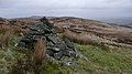
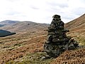
 Craigmoddie Fell Cairn - geograph.org.uk - 561354.jpg 640 × 480; 117 KB
-
 Craigmoddie Fell Cairn - geograph.org.uk - 561484.jpg 640 × 480; 123 KB
-
 Craignarget Hill - geograph.org.uk - 727114.jpg 640 × 480; 102 KB
-
 Craignaw summit cairn (geograph 3810684).jpg 1,600 × 1,067; 306 KB
-
 Craignelder cairn. - geograph.org.uk - 514215.jpg 640 × 480; 73 KB
-
 Crash site memorial - geograph.org.uk - 579437.jpg 480 × 640; 121 KB
-
 Creebridge Cairn - geograph.org.uk - 458830.jpg 640 × 480; 142 KB
-
 Creebridge Cairn - geograph.org.uk - 459765.jpg 640 × 480; 166 KB
-
 Cross Water of Luce near Glenwhilly - geograph.org.uk - 563797.jpg 480 × 640; 91 KB
-
 Culshabbin from Mochrum Fell - geograph.org.uk - 721142.jpg 640 × 480; 88 KB
-
 Deer on the 'old military road' - geograph.org.uk - 1780479.jpg 2,560 × 1,920; 838 KB
-
 Deer Stalkers Hide on the Glassoch Fell - geograph.org.uk - 523288.jpg 640 × 480; 130 KB
-
 Derriscoal - geograph.org.uk - 475984.jpg 640 × 480; 82 KB
-
 Derry Farm - geograph.org.uk - 561297.jpg 640 × 480; 123 KB
-
 Detail of the Cairn at Lochinvar - geograph.org.uk - 528311.jpg 640 × 480; 101 KB
-
 Dirniemow Bridge - geograph.org.uk - 313519.jpg 640 × 480; 82 KB
-
 Douglas's Cairn, Criffel - geograph.org.uk - 1418389.jpg 640 × 480; 57 KB
-
 Douglas's Cairn, Criffel - geograph.org.uk - 629270.jpg 640 × 480; 83 KB
-
 Drumnahern - geograph.org.uk - 710783.jpg 640 × 480; 73 KB
-
 Dugland. - geograph.org.uk - 75496.jpg 640 × 378; 39 KB
-
 Dungeon Hill cairn - geograph.org.uk - 144558.jpg 640 × 480; 89 KB
-
 Dyke at the march gate - geograph.org.uk - 665665.jpg 473 × 640; 191 KB
-
 Dyke, Bainloch Hill - geograph.org.uk - 855224.jpg 640 × 480; 61 KB
-
 East Cairngaan Cottage - geograph.org.uk - 746720.jpg 640 × 480; 66 KB
-
 Eastman's Cairn - geograph.org.uk - 322350.jpg 600 × 400; 36 KB
-
 Eldrig Fell - geograph.org.uk - 447227.jpg 640 × 480; 61 KB
-
 Entrance to Auchencairn - geograph.org.uk - 731618.jpg 640 × 480; 101 KB
-
 Entrance to Barncrosh. - geograph.org.uk - 523592.jpg 640 × 480; 94 KB
-
 Farm machinery never dies - geograph.org.uk - 621838.jpg 640 × 480; 73 KB
-
 Farmland and site of cairn - geograph.org.uk - 444845.jpg 640 × 480; 144 KB
-
 Farmland near Barquhill - geograph.org.uk - 779696.jpg 640 × 480; 69 KB
-
 Farmland near Culquhasan road - geograph.org.uk - 583449.jpg 640 × 488; 74 KB
-
 Farmland near Culroy - geograph.org.uk - 868309.jpg 640 × 489; 111 KB
-
 Farmland round Barwhirran - geograph.org.uk - 435081.jpg 640 × 480; 89 KB
-
 Farmland, Drumraik - geograph.org.uk - 314510.jpg 640 × 465; 52 KB
-
 Fell Hill trig pillar and cairn, Balmaclellan.jpg 1,600 × 1,200; 787 KB
-
 Field at Machermore, near Glenluce - geograph.org.uk - 163176.jpg 640 × 480; 77 KB
-
 Field boundaries - wall and hedge - geograph.org.uk - 163163.jpg 640 × 480; 108 KB
-
 Field West of Cairn Hill - geograph.org.uk - 739390.jpg 640 × 427; 87 KB
-
 Fire watch Tower on the Glassoch Fell - geograph.org.uk - 523161.jpg 640 × 480; 146 KB
-
 Footbridge over the Luce - geograph.org.uk - 1168930.jpg 640 × 480; 110 KB
-
 Ford on farm track - geograph.org.uk - 165899.jpg 640 × 480; 112 KB
-
 Forest Cairn. - geograph.org.uk - 518511.jpg 640 × 480; 138 KB
-
 Forest Clearing - geograph.org.uk - 519082.jpg 640 × 480; 141 KB
-
 Forest Firebreak - geograph.org.uk - 764343.jpg 640 × 479; 123 KB
-
 Forest Firebreak - geograph.org.uk - 764360.jpg 640 × 479; 110 KB
-

-

-
 Forest Track, Screel Hill - geograph.org.uk - 324192.jpg 640 × 427; 133 KB
-

-
 Frosty stones - geograph.org.uk - 654766.jpg 480 × 640; 128 KB
-

-
 Garheugh Port - geograph.org.uk - 450688.jpg 640 × 480; 105 KB
-
 Garheugh Port from the A747 - geograph.org.uk - 577244.jpg 640 × 439; 37 KB
-
 Glasnick Smithy Croft.jpg 3,648 × 2,736; 4.6 MB
-
 Glenhead, Auchencairn - geograph.org.uk - 735942.jpg 640 × 480; 69 KB
-
 Glenswinton, Cairn Hill - geograph.org.uk - 723188.jpg 640 × 480; 73 KB
-
 Glenswinton, Castledaffin - geograph.org.uk - 723206.jpg 640 × 480; 79 KB
-
 Harestanes Heights summit cairn - geograph.org.uk - 1425589.jpg 640 × 425; 284 KB
-

-

-
 Haughs, Nether Hazelfield - geograph.org.uk - 370707.jpg 640 × 480; 93 KB
-
 Hawthorn bush and dyke - geograph.org.uk - 475937.jpg 640 × 480; 150 KB
-
 Heavy Plant Crossing^ - geograph.org.uk - 520317.jpg 640 × 480; 127 KB
-
 High Eldrig - geograph.org.uk - 447306.jpg 640 × 480; 64 KB
-
 High Gillespie chambered cairn - geograph.org.uk - 727131.jpg 640 × 480; 149 KB
-
 Hillside Cairn - geograph.org.uk - 715353.jpg 640 × 360; 46 KB
-
 Hilltop cairn on Bishop Forest Hill - geograph.org.uk - 715383.jpg 640 × 360; 60 KB
-
 Houses at Kirklauchline - geograph.org.uk - 621848.jpg 640 × 480; 72 KB
-
 Housing near Cairngarroch - geograph.org.uk - 621844.jpg 640 × 480; 58 KB
-
 Ice House - geograph.org.uk - 259860.jpg 640 × 480; 65 KB
-
 In the Lily Glen - geograph.org.uk - 727156.jpg 640 × 492; 149 KB
-
 Junction at Barwhirran Croft - geograph.org.uk - 448131.jpg 640 × 480; 69 KB
-
 Kilhern - geograph.org.uk - 1060461.jpg 640 × 354; 43 KB
-
 Kilhern - geograph.org.uk - 460.jpg 640 × 480; 97 KB
-
 Kilhern Loch - geograph.org.uk - 475912.jpg 640 × 457; 96 KB
-
 Kilmacfadzean - geograph.org.uk - 543632.jpg 640 × 466; 83 KB
-
 Knockiebae Plantation - geograph.org.uk - 563749.jpg 640 × 480; 96 KB
-

-
 Langholm - geograph-3585591-by-Walter-Baxter.jpg 640 × 480; 169 KB
-
 Larg Hill from Craignaw - geograph.org.uk - 1218060.jpg 640 × 480; 74 KB
-
 Last one standing^ - geograph.org.uk - 563768.jpg 640 × 472; 78 KB
-
 Little Cairnbrock, The Rhins - geograph.org.uk - 594063.jpg 640 × 480; 68 KB
-
 Little Float Farm from Cairn Hill - geograph.org.uk - 758307.jpg 640 × 480; 73 KB
-
 Loch Head - geograph.org.uk - 452361.jpg 640 × 480; 74 KB
-
 Lochans of Cairndoon - geograph.org.uk - 334723.jpg 640 × 480; 41 KB
-
 Log cabin, Torwood House Hotel - geograph.org.uk - 264963.jpg 640 × 457; 144 KB
-
 Long Cairn - geograph.org.uk - 501306.jpg 640 × 480; 145 KB
-
 Looking across to the Galloway hills - geograph.org.uk - 1768761.jpg 2,560 × 1,920; 973 KB
-
 Looking down Crotteagh Hill - geograph.org.uk - 516570.jpg 640 × 480; 70 KB
-
 Looking out of Knowe village - geograph.org.uk - 663352.jpg 640 × 480; 70 KB
-


_-_geograph.org.uk_-_1498789.jpg)


.jpg)


