Category:Cal Felip (Golmés)
Jump to navigation
Jump to search
| Object location | | View all coordinates using: OpenStreetMap |
|---|
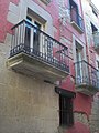
house in Golmés, Spain  | |||||
| Upload media | |||||
| Instance of | |||||
|---|---|---|---|---|---|
| Location | Golmés, Pla d'Urgell, Lleida Province, Catalonia | ||||
| Street address |
| ||||
| Architectural style | |||||
| Heritage designation |
| ||||
 | |||||
Català: Casa de Cal Felip, a la plaça Major de Golmés (Pla d'Urgell)
This is a category about a building listed in the Catalan heritage register as Bé Cultural d'Interès Local (BCIL) under the reference IPA-14768. |
Media in category "Cal Felip (Golmés)"
The following 3 files are in this category, out of 3 total.
-
 Felip02.JPG 2,448 × 3,264; 4.14 MB
-
 Felip03.JPG 3,264 × 2,448; 2.46 MB
-
 Felip1.JPG 2,448 × 3,264; 3.79 MB

