Category:Cal Ferro
Jump to navigation
Jump to search
| Object location | | View all coordinates using: OpenStreetMap |
|---|
building in Rubí, Spain .jpg) | |||||
| Upload media | |||||
| Instance of | |||||
|---|---|---|---|---|---|
| Location | Rubí, Barcelona Province, Catalonia | ||||
| Architectural style | |||||
| Heritage designation |
| ||||
 | |||||
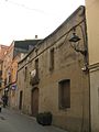
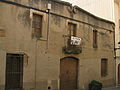
Català: Cal Ferro, al carrer de Sant Cugat núm. 32 (Rubí). Obra popular de començament del segle XIX.
This is a category about a building listed in the Catalan heritage register as Bé Cultural d'Interès Local (BCIL) under the reference IPA-39470. |
Media in category "Cal Ferro"
The following 3 files are in this category, out of 3 total.
-
 063 Cal Ferro, c. Sant Cugat.jpg 1,704 × 2,272; 876 KB
-
 064 Cal Ferro, c. Sant Cugat.jpg 2,272 × 1,704; 1.09 MB
-
 Cal Ferro (Rubí).jpg 1,375 × 1,487; 268 KB

