Category:Canyon Bridge (Yellowstone National Park)
Jump to navigation
Jump to search
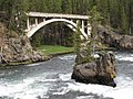
English: The Canyon Bridge was completed in 1914 and opened to the public in 1915. It spans the normally-dry Jay Creek at its confluence with the Yellowstone River near the river's Upper Falls. Long since closed to automobile traffic, the bridge is now part of the North Rim Trail.
 | |||||
| Upload media | |||||
| Instance of | |||||
|---|---|---|---|---|---|
| Location | Park County, Wyoming | ||||
| Inception |
| ||||
 | |||||
Media in category "Canyon Bridge (Yellowstone National Park)"
The following 12 files are in this category, out of 12 total.
-
 - panoramio - trukdotcom (57).jpg 900 × 1,200; 737 KB
-
 Cross-country skiing Old Canyon Bridge Trail (3) (39278956184).jpg 7,548 × 5,032; 21.6 MB
-

-

-

-

-
 North Rim Trail - Grand Canyon of Yellowstone - panoramio.jpg 2,816 × 2,112; 2.17 MB
-
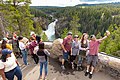 People enjoying the view from Uncle Tom's Point (48862450292).jpg 8,688 × 5,792; 32.31 MB
-

-
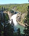
 Upper Falls from Uncle Tom's Point (48637332598).jpg 8,688 × 5,792; 36.59 MB
-
 Upper Falls in Yellowstone National Park DyeClan.com - panoramio.jpg 2,448 × 3,264; 4.73 MB
-
 YellowstoneRiver, Crittenden Bridge & Upper Falls 9-11 (25817980511).jpg 2,577 × 3,200; 2.12 MB
.jpg)
_(39278956184).jpg)
.png)
.jpg)
.jpg)

.jpg)