Category:Cape Wickham Lighthouse
Jump to navigation
Jump to search
| Object location | | View all coordinates using: OpenStreetMap |
|---|
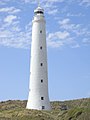
English: Cape Wickham Lighthouse is the tallest lighthouse in Australia. It marks the southern side of the main entrance to Bass Strait, standing opposite Cape Otway, Victoria. Located on the northern point of King Island.
lighthouse in Tasmania, Australia  | |||||
| Upload media | |||||
| Instance of | |||||
|---|---|---|---|---|---|
| Location |
| ||||
| Heritage designation |
| ||||
| Inception |
| ||||
 | |||||
Media in category "Cape Wickham Lighthouse"
The following 3 files are in this category, out of 3 total.
-
 Cape Wickham Lighthouse (King Island).jpg 2,736 × 3,648; 2.02 MB
-
 Cape Wickham Lighthouse 1887.jpg 728 × 950; 49 KB
-
 Cape Wickham Lighthouse and quarters, King Island, Bass Strait.jpg 596 × 416; 33 KB
.jpg)
