Category:Cape Engaño Lighthouse
Jump to navigation
Jump to search
| Object location | | View all coordinates using: OpenStreetMap |
|---|
|
This is a category about a cultural heritage property in the Philippines with ID PH-02-0008
|
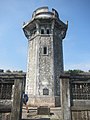
English: Cape Engaño Lighthouse
lighthouse in Palaui Island, Philippines  The lighthouse on Palaui Island was built during the Spanish colonial era and first lit on December 30, 1892. .jpg) | |||||
| Upload media | |||||
| Instance of | |||||
|---|---|---|---|---|---|
| Location |
| ||||
| Located in or next to body of water | |||||
| Heritage designation | |||||
| Service entry |
| ||||
| Inception |
| ||||
| Source of energy | |||||
| Height |
| ||||
| Different from | |||||
 | |||||
Subcategories
This category has only the following subcategory.
Media in category "Cape Engaño Lighthouse"
The following 24 files are in this category, out of 24 total.
-
 Around Cape Engano.JPG 600 × 800; 155 KB
-
 Cape Engano Angle.JPG 800 × 600; 111 KB
-
 Cape Engano Back.JPG 600 × 800; 126 KB
-
 Cape Engano Hallway.JPG 600 × 800; 160 KB
-
 Cape Engano Lighthouse (Yvette Tan) - Flickr.jpg 3,776 × 2,520; 4.37 MB
-
 Cape Engano Lighthouse Facade.jpg 3,000 × 4,000; 2.68 MB
-
 Cape Engano of Palaui Island.jpg 3,000 × 2,000; 5.29 MB
-
 Cape Engaño Lighthouse (Tessa Pagdanganan) - Flickr.jpg 1,296 × 1,936; 1.19 MB
-
 Cape Engaño Lighthouse - Palaui Island, Cagayan.jpg 4,288 × 2,848; 5.24 MB
-
 Cape Engaño Lighthouse, Cagayan, Philippines.jpg 800 × 575; 210 KB
-
 Cape Engaño Lighthouse.jpg 4,016 × 6,016; 4.93 MB
-
 Dos Hermanos, Palaui Island.jpg 3,613 × 5,888; 4.49 MB
-
 Faro de Cabo Engaño Lighthouse.jpg 2,592 × 1,944; 1.15 MB
-
 Front Terrace of Light House Palaui Island, Cagayan Philippines.jpg 960 × 686; 160 KB
-
 Inside Cape Engano.JPG 600 × 800; 129 KB
-
 LIGHT HOUSE, Palaui Island, Cagayan Philippines.jpg 500 × 700; 77 KB
-
 Lighthouse of Cape Engano, Philippines.jpg 960 × 540; 97 KB
-
 Lighthouse of Cape Engaño.JPG 1,584 × 2,816; 1.33 MB
-
 Lighthouse Tower of Cape Engano.jpg 540 × 960; 87 KB
-
 Memories of Cape Engaño.jpg 716 × 1,089; 250 KB
-

-
 Parola ng Cape Engano Side.JPG 600 × 800; 128 KB
-
 Parola ng Cape Engano.JPG 1,706 × 3,673; 3.94 MB
-
 Philippine Island - NARA - 68155736.jpg 6,895 × 5,360; 17.54 MB


_-_Flickr.jpg)


_-_Flickr.jpg)


Categories:
- Cultural heritage monuments in Cagayan (province)
- Lighthouses in the Philippines by name
- Buildings in Cagayan (province)
- Palaui Island
- Lighthouses built in 1892
- Stone lighthouses
- Solar-powered lighthouses
- Lighthouses in the Philippine Sea
- Unpainted lighthouses
- Landfall lights
- Lighthouses by range, 25 to 29 nm