Category:Capul Island Lighthouse
Jump to navigation
Jump to search
| Object location | | View all coordinates using: OpenStreetMap |
|---|
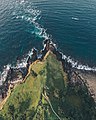
English: Capul Island Lighthouse
lighthouse in the Philippines  | |||||
| Upload media | |||||
| Instance of | |||||
|---|---|---|---|---|---|
| Location |
| ||||
| Located in or next to body of water |
| ||||
| Heritage designation |
| ||||
| Service entry |
| ||||
| Inception |
| ||||
| Height |
| ||||
 | |||||
Media in category "Capul Island Lighthouse"
The following 6 files are in this category, out of 6 total.
-
 Capul lighthouse in Northen samar.jpg 3,200 × 4,000; 4.03 MB
-
 Capul Lighthouse,Northern Samar.jpg 800 × 556; 181 KB
-
 Capul lighthouse.jpg 1,600 × 1,200; 346 KB
-
 Inbound7188120257094756352.jpg 2,899 × 2,175; 2.03 MB
-
 Parola ng Capul historical marker 01 (cropped).jpg 379 × 506; 163 KB
-
 Parola ng Capul historical marker 01.jpg 1,155 × 866; 609 KB


.jpg)
