Category:Carriage ramps and catacombs, St James's Gardens
Jump to navigation
Jump to search
| Object location | | View all coordinates using: OpenStreetMap |
|---|
building in Liverpool, Merseyside, England, UK  | |||||
| Upload media | |||||
| Instance of | |||||
|---|---|---|---|---|---|
| Location | Liverpool, Merseyside, North West England, England | ||||
| Heritage designation |
| ||||
 | |||||
This is a category about listed building number 1073467. |
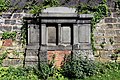
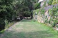
The carriage ramps run north-south along the eastern wall of St James's Gardens and provided a gentle slope into the cemetery from Hope Street. There are graves and tombs along their lower sections. The catacombs are cut into the lower stone walls of the former quarry.
Media in category "Carriage ramps and catacombs, St James's Gardens"
The following 9 files are in this category, out of 9 total.
-
 Tomb of Sir William Brown, St James's Gardens, Liverpool.jpg 4,936 × 3,284; 13.05 MB
-
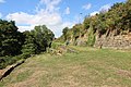 Carriage ramps, St James's Gardens 1.jpg 5,184 × 3,456; 10.87 MB
-
 Carriage ramps, St James's Gardens 2.jpg 5,184 × 3,456; 10.12 MB
-
 Carriage ramps, St James's Gardens 3.jpg 5,184 × 3,456; 10.29 MB
-
 Carriage ramps, St James's Gardens 4.jpg 5,184 × 3,456; 12.93 MB
-
 Carriage ramps, St James's Gardens 5.jpg 5,184 × 3,456; 11.1 MB
-
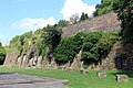 Catacombs, St James's Gardens.jpg 5,184 × 3,456; 13.49 MB
-
 Gow & Kinsley gravestones, St James's Gardens.jpg 5,184 × 3,456; 12.23 MB
-
 Nicholson gravestone, St James's Gardens, Liverpool.jpg 5,184 × 3,456; 15.14 MB


