Category:Castle, La Couvertoirade
Jump to navigation
Jump to search
| Object location | | View all coordinates using: OpenStreetMap |
|---|
|
This building is classé au titre des monuments historiques de la France. It is indexed in the base Mérimée, a database of architectural heritage maintained by the French Ministry of Culture, under the reference PA00094005
|
commandry located in Aveyron, in France  | |||||
| Upload media | |||||
| Instance of |
| ||||
|---|---|---|---|---|---|
| Location | La Couvertoirade, canton of Nant | ||||
| Heritage designation |
| ||||
 | |||||
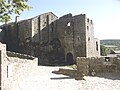
English: The castle of the Templars. (Mark label 4 on the plan of the Office of Tourism)
Español: El castillo de los Templaros. (Marca 4 en el plan de la Oficina de Turismo)
Français : Le château des Templiers. (Repère 4 sur le plan de l'Office de Tourisme)
Subcategories
This category has the following 2 subcategories, out of 2 total.
B
- Barbican, La Couvertoirade (7 F)
É
- Écuries de La Couvertoirade (2 F)
Media in category "Castle, La Couvertoirade"
The following 15 files are in this category, out of 15 total.
-
 Chateau couvertoirade.JPG 1,024 × 768; 374 KB
-
 Chateau La Couvertoirade.jpg 2,776 × 3,970; 7.97 MB
-
 Commanderie la couvertoirade.JPG 3,488 × 2,616; 2.23 MB
-
 Commandery Castle in la Couvertoirade 01.jpg 3,594 × 5,548; 13.12 MB
-
 Commandery Castle in la Couvertoirade 02.jpg 5,671 × 3,554; 15.59 MB
-
 Commandery Castle in la Couvertoirade 03.jpg 2,876 × 4,832; 10.73 MB
-
 Commandery Castle in la Couvertoirade 04.jpg 3,618 × 5,875; 20.08 MB
-
 Commandery Castle in la Couvertoirade 05.jpg 3,111 × 5,197; 12.35 MB
-
 Donjon-et-les-restes-du-château-à-La-Couvertoirade-IMG 0126-.jpg 1,932 × 2,576; 3.06 MB
-
 Donjon-et-les-restes-du-château-à-La-Couvertoirade-IMG 0128-.jpg 1,932 × 2,576; 4.04 MB
-
 La couvertoirade chateau inetrieur.jpg 3,456 × 2,304; 3.27 MB
-
 La Couvertoirade chateau.jpg 3,264 × 2,448; 8.16 MB
-
 La Couvertoirade-Château de Templiers-20130616.jpg 4,200 × 5,250; 8.09 MB
-
 La Couvertoirade-Château-20130516.jpg 7,000 × 4,500; 9.23 MB
-
 La Couvertoirade.jpg 3,648 × 2,056; 5.18 MB


