Category:Castle ruins in Czarny Bór
Jump to navigation
Jump to search
| Object location | | View all coordinates using: OpenStreetMap |
|---|
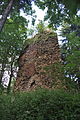
castle in Czarny Bór, Lower Silesian Voivodeship, Poland  | |||||
| Upload media | |||||
| Instance of | |||||
|---|---|---|---|---|---|
| Location | Czarny Bór, Gmina Czarny Bór, Wałbrzych County, Lower Silesian Voivodeship, Poland | ||||
| Architectural style | |||||
| Heritage designation |
| ||||
 | |||||
Polski: Czarny Bór - ruiny zamku z XIV-XV wieku.
Media in category "Castle ruins in Czarny Bór"
The following 8 files are in this category, out of 8 total.
-
 Czarny Bór - castle 01.jpg 2,848 × 4,288; 6.18 MB
-
 Czarny Bór - castle 02.jpg 2,848 × 4,288; 6.26 MB
-
 Czarny Bór - castle 03.jpg 4,288 × 2,848; 6.24 MB
-
 Czarny Bór - castle 04.jpg 2,848 × 4,288; 6.23 MB
-
 Czarny Bór ruiny zamku Liebenau 2003.jpg 768 × 1,024; 933 KB
-
 Liebenau Schwarzwaldau 5 maja 2003.jpg 768 × 1,024; 883 KB
-
 Ruiny zamku w Czarnym Borze 05 2002.JPG 1,200 × 1,600; 559 KB
-
 Ruiny zamku w Czarnym Borze.jpg 1,126 × 1,680; 1.49 MB


