Category:Catton, East Riding of Yorkshire
Jump to navigation
Jump to search
civil parish in East Riding of Yorkshire, England   | |||||
| Upload media | |||||
| Instance of | |||||
|---|---|---|---|---|---|
| Location | East Riding of Yorkshire, Yorkshire and the Humber, England | ||||
| Population |
| ||||
| official website | |||||
 | |||||
Subcategories
This category has the following 3 subcategories, out of 3 total.
Media in category "Catton, East Riding of Yorkshire"
The following 109 files are in this category, out of 109 total.
-
 A minor road at Black Plantation - geograph.org.uk - 2470151.jpg 800 × 600; 294 KB
-
 A path heading to High Catton - geograph.org.uk - 3131143.jpg 800 × 600; 243 KB
-
 A path heading to High Catton - geograph.org.uk - 3131148.jpg 800 × 600; 313 KB
-
 A1079 at Moorfield Farm - geograph.org.uk - 6824616.jpg 1,024 × 726; 182 KB
-
 Allotments in Stamford Bridge - geograph.org.uk - 1824966.jpg 640 × 480; 149 KB
-
 Along Howl Gate - geograph.org.uk - 6447902.jpg 1,024 × 683; 415 KB
-
 Along Long Lane - geograph.org.uk - 5358101.jpg 640 × 427; 249 KB
-
 Approaching Stamford Bridge - geograph.org.uk - 1824964.jpg 640 × 480; 153 KB
-
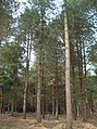
 Black Plantation - geograph.org.uk - 2371468.jpg 1,600 × 1,200; 579 KB
-
 Black Plantation - geograph.org.uk - 399254.jpg 478 × 640; 214 KB
-
 Bovine reflection, near Wilberfoss (geograph 5744799).jpg 489 × 640; 159 KB
-
 Bridleway to Low Catton - geograph.org.uk - 1824860.jpg 640 × 480; 120 KB
-
 Bridleway towards Town End Farm - geograph.org.uk - 3928578.jpg 1,600 × 1,200; 445 KB
-
 Bronze axe dating from c.1900- 1600 BC (FindID 256322).jpg 800 × 927; 137 KB
-
 Catton Park on Ling Lane (geograph 3131098).jpg 800 × 600; 343 KB
-
 Catton Road - geograph.org.uk - 6447905.jpg 1,024 × 683; 448 KB
-
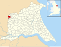 Catton, East Riding of Yorkshire UK parish locator map.svg 1,425 × 1,107; 1.68 MB
-
 Church graveyard, Low Catton - geograph.org.uk - 2371935.jpg 1,600 × 1,200; 804 KB
-
 Church Lane at Low Catton Road junction - geograph.org.uk - 4881207.jpg 4,608 × 3,456; 2.78 MB
-
 Common Lane towards Common Farm - geograph.org.uk - 2372029.jpg 1,600 × 1,200; 755 KB
-
 Course of the railway - geograph.org.uk - 3763538.jpg 640 × 427; 92 KB
-
 Crop field on Primrose Hill - geograph.org.uk - 6494396.jpg 1,024 × 768; 168 KB
-
 Crossroads in High Catton - geograph.org.uk - 6709992.jpg 1,024 × 683; 222 KB
-
 Crossroads in High Catton village - geograph.org.uk - 4881223.jpg 4,608 × 3,456; 3.68 MB
-
 Daffodils beside Long Lane - geograph.org.uk - 5358109.jpg 640 × 427; 205 KB
-
 Duck pond by Howl Gate - geograph.org.uk - 6447897.jpg 1,024 × 683; 546 KB
-
 Entering High Catton - geograph.org.uk - 5358116.jpg 427 × 640; 229 KB
-
 Entering Low Catton - geograph.org.uk - 1824915.jpg 640 × 480; 139 KB
-
 Entrance to the Black Plantation - geograph.org.uk - 6494438.jpg 1,024 × 768; 385 KB
-
 Fangfoss Plantation - geograph.org.uk - 6494442.jpg 1,024 × 768; 209 KB
-
 Farmland beside Howl Gate - geograph.org.uk - 6447904.jpg 1,024 × 683; 460 KB
-
 Farmland beside Ling Lane (geograph 6447891).jpg 1,024 × 683; 599 KB
-
 Farmland from High Catton Road - geograph.org.uk - 5358138.jpg 640 × 427; 191 KB
-
 Farmland south of Stamford Bridge - geograph.org.uk - 5358142.jpg 640 × 427; 164 KB
-
 Field and Disused Railway. - geograph.org.uk - 2498066.jpg 3,264 × 2,448; 1.7 MB
-
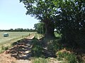
 Field entrance off Long Lane - geograph.org.uk - 2371894.jpg 1,600 × 1,200; 666 KB
-
 Field entrance off Long Lane - geograph.org.uk - 2371903.jpg 1,600 × 1,200; 567 KB
-
 Field near High Catton - geograph.org.uk - 3520205.jpg 446 × 640; 186 KB
-
 Field near Low Catton - geograph.org.uk - 3518628.jpg 640 × 426; 199 KB
-
 Field path by Primrose Hill - geograph.org.uk - 6494405.jpg 1,024 × 768; 180 KB
-
 Field path by the road - geograph.org.uk - 6494414.jpg 1,024 × 768; 199 KB
-
 Fields beside Ling Lane (geograph 6877813).jpg 1,024 × 460; 214 KB
-
 Fields near High Catton - geograph.org.uk - 3520174.jpg 496 × 640; 183 KB
-
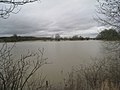 Floods at Kexby - geograph.org.uk - 3279892.jpg 1,024 × 768; 159 KB
-
 Footpath crossing Smackdam Beck - geograph.org.uk - 3928573.jpg 1,600 × 1,200; 1.04 MB
-
 Footpath near Low Catton - geograph.org.uk - 3520194.jpg 492 × 640; 224 KB
-
 Footpath over field toward High Catton - geograph.org.uk - 4881232.jpg 4,608 × 3,456; 4.37 MB
-
 Former York - Beverley Railway - geograph.org.uk - 1400974.jpg 640 × 482; 129 KB
-
 Foss Beck - geograph.org.uk - 211203.jpg 640 × 479; 55 KB
-
 Garden Cottage - geograph.org.uk - 5358083.jpg 640 × 427; 234 KB
-
 Garden Cottage east of Kexby - geograph.org.uk - 3928583.jpg 1,600 × 1,200; 622 KB
-
 High Catton - geograph.org.uk - 3520187.jpg 640 × 455; 209 KB
-
 High Catton Grange - geograph.org.uk - 3766472.jpg 640 × 427; 72 KB
-
 High Catton Road - geograph.org.uk - 5358130.jpg 640 × 427; 195 KB
-
 High Catton Road - geograph.org.uk - 5358146.jpg 640 × 427; 183 KB
-
 High Catton village - geograph.org.uk - 6494418.jpg 1,024 × 768; 173 KB
-
 Howl Gate - geograph.org.uk - 6447899.jpg 1,024 × 683; 464 KB
-
 Howl Gate to the left - geograph.org.uk - 6494421.jpg 1,024 × 768; 230 KB
-
 Howl Gate, near High Catton - geograph.org.uk - 3518616.jpg 468 × 640; 213 KB
-
 Junction of Ling Lane and Newbridge Lane (geograph 4878317).jpg 4,608 × 3,456; 3.16 MB
-
 Junction of Long Lane and A1079 - geograph.org.uk - 3166311.jpg 2,560 × 1,920; 2.21 MB
-
 Kexby Bridge - geograph.org.uk - 6116934.jpg 2,048 × 1,536; 1.02 MB
-
 Ling Lane (geograph 6877815).jpg 1,024 × 683; 337 KB
-
 Ling Lane towards Wilberfoss - geograph.org.uk - 2371497.jpg 1,600 × 1,200; 442 KB
-
 Little used footpath over winter crop - geograph.org.uk - 4881235.jpg 3,456 × 4,608; 5.03 MB
-
 Lofthouse Lane towards High Catton - geograph.org.uk - 2372024.jpg 1,600 × 1,200; 575 KB
-
 Long Lane - geograph.org.uk - 5358090.jpg 640 × 427; 239 KB
-
 Long Lane heading north towards Low Catton - geograph.org.uk - 2371900.jpg 1,600 × 1,200; 380 KB
-
 Low Catton to High Catton road - geograph.org.uk - 1824950.jpg 640 × 480; 119 KB
-
 Merrilthorne Farm, High Catton - geograph.org.uk - 3136313.jpg 800 × 600; 283 KB
-
 Merrilthorne Farm, High Catton - geograph.org.uk - 3136316.jpg 800 × 600; 318 KB
-
 Minor road beside Black Plantation - geograph.org.uk - 2371484.jpg 1,600 × 1,200; 583 KB
-
 Mitchell Lane towards High Catton Grange - geograph.org.uk - 2372033.jpg 1,600 × 1,200; 530 KB
-
 Near Town End - geograph.org.uk - 6116937.jpg 2,048 × 1,536; 1.12 MB
-
 Path to Carberry Hall Farm (geograph 6494447).jpg 1,024 × 768; 255 KB
-
 Pheasant crosses Long Lane - geograph.org.uk - 5358092.jpg 640 × 427; 211 KB
-
 Phonebox in High Catton - geograph.org.uk - 5358127.jpg 640 × 427; 193 KB
-
 Ploughed field north of Wilberfoss - geograph.org.uk - 2371501.jpg 1,600 × 1,200; 395 KB
-
 Pond at High Catton Grange - geograph.org.uk - 6494425.jpg 1,024 × 768; 189 KB
-
 Poppies near High Catton - geograph.org.uk - 3518505.jpg 462 × 640; 220 KB
-
 Poultry farm - geograph.org.uk - 5358098.jpg 640 × 427; 196 KB
-
 Pylons by Fairfield Farm - geograph.org.uk - 6494434.jpg 1,024 × 768; 138 KB
-
 Rape near Town End Plantation - geograph.org.uk - 1824899.jpg 640 × 480; 121 KB
-
 River Derwent near Kexby - geograph.org.uk - 2371890.jpg 1,600 × 1,200; 543 KB
-
 River Derwent with Low Catton beyond - geograph.org.uk - 2494246.jpg 3,264 × 2,448; 2.76 MB
-
 Road through Black Plantation - geograph.org.uk - 6447896.jpg 1,024 × 683; 601 KB
-
 Road to Stamford Bridge - geograph.org.uk - 1824961.jpg 640 × 480; 123 KB
-
 Road to Stamford Bridge - geograph.org.uk - 3763534.jpg 640 × 427; 79 KB
-
 Sheep and lambs - geograph.org.uk - 1824854.jpg 640 × 480; 164 KB
-
 Sheep near Kexby - geograph.org.uk - 1824836.jpg 640 × 480; 114 KB
-

-
 Street scene in High Catton village - geograph.org.uk - 4881217.jpg 4,608 × 3,456; 3.77 MB
-
 The disused Chapel at High Catton - geograph.org.uk - 3131163.jpg 800 × 600; 344 KB
-

-
 The Ings - geograph.org.uk - 6116933.jpg 2,048 × 1,536; 1.28 MB
-
 The junction to High and Low Catton - geograph.org.uk - 2470144.jpg 800 × 600; 241 KB
-
 Throwmires Beck - geograph.org.uk - 2372019.jpg 1,600 × 1,200; 416 KB
-
 Towards Long Lane - geograph.org.uk - 1824892.jpg 640 × 480; 131 KB
-
 Towards Springview Cottage - geograph.org.uk - 5358113.jpg 640 × 427; 200 KB
-
 Towards York - geograph.org.uk - 399325.jpg 640 × 478; 136 KB
-
 Town End Plantation - geograph.org.uk - 1824903.jpg 640 × 480; 138 KB
-
 Track to Low Catton - geograph.org.uk - 1824885.jpg 640 × 480; 165 KB
-
 Track to White House Farm - geograph.org.uk - 2371437.jpg 1,600 × 1,200; 378 KB
-
 Track towards the Derwent - geograph.org.uk - 5358094.jpg 640 × 427; 199 KB
-
 Tree in a field - geograph.org.uk - 5358139.jpg 640 × 427; 184 KB
-
 Turf growing near Wilberfoss (geograph 5415046).jpg 640 × 480; 316 KB
-
 West Farm, Low Catton - geograph.org.uk - 2371916.jpg 1,600 × 1,062; 247 KB
-
 Whinberry Hill Farm - geograph.org.uk - 2371494.jpg 1,600 × 1,200; 375 KB
-
 Woodland near Rectory Farm - geograph.org.uk - 2371940.jpg 1,600 × 1,200; 836 KB


.jpg)


.jpg)
.jpg)


.jpg)


.jpg)


.jpg)


.jpg)


.jpg)


.jpg)


