Category:Château de la Roca d'Anyer (Nyer)
Jump to navigation
Jump to search
| Object location | | View all coordinates using: OpenStreetMap |
|---|
|
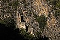
This building is inscrit au titre des monuments historiques de la France. It is indexed in the base Mérimée, a database of architectural heritage maintained by the French Ministry of Culture, under the reference PA00104053
|
 | |||||
| Upload media | |||||
| Instance of | |||||
|---|---|---|---|---|---|
| Location | Nyer, Conflent, Pyrénées-Orientales, Occitania, Metropolitan France, France | ||||
| Street address |
| ||||
| Heritage designation |
| ||||
| Elevation above sea level |
| ||||
 | |||||
Subcategories
This category has only the following subcategory.
É
- Église Notre-Dame-de-la-Roca (1 F)
Media in category "Château de la Roca d'Anyer (Nyer)"
The following 3 files are in this category, out of 3 total.
-
 Nyer - Château de la Roca d'Anyer.jpg 947 × 1,173; 277 KB
-
 Nyer 1267.jpg 5,616 × 3,744; 11.92 MB
-
 Nyer 1273.jpg 4,439 × 2,958; 9.27 MB

