Category:Chapel Cemetery in Lądek-Zdrój
Jump to navigation
Jump to search
| Object location | | View all coordinates using: OpenStreetMap |
|---|
 | |||||
| Upload media | |||||
| Instance of | |||||
|---|---|---|---|---|---|
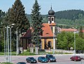
| Location | Lądek-Zdrój, Gmina Lądek-Zdrój, Kłodzko County, Lower Silesian Voivodeship, Poland | ||||
| Architectural style | |||||
| Adjacent building | |||||
 | |||||
Media in category "Chapel Cemetery in Lądek-Zdrój"
The following 8 files are in this category, out of 8 total.
-
 2014 Lądek-Zdrój, kaplica cmentarna 01.jpg 1,932 × 2,592; 3.77 MB
-
 2014 Lądek-Zdrój, kaplica cmentarna 02.jpg 3,528 × 2,592; 6.38 MB
-
 2014 Lądek-Zdrój, kaplica cmentarna 03.jpg 2,470 × 3,246; 5.29 MB
-
 2014 Lądek-Zdrój, kaplica cmentarna 04.jpg 2,978 × 2,136; 5.15 MB
-
 2014 Lądek-Zdrój, kaplica cmentarna 05.jpg 2,034 × 2,704; 4.2 MB
-
 2014 Lądek-Zdrój, kaplica cmentarna 06.jpg 2,174 × 2,895; 5.52 MB
-
 2014 Lądek-Zdrój, kaplica cmentarna 07.jpg 2,694 × 2,055; 3.94 MB
-
 2014 Lądek-Zdrój, kaplica cmentarna 08.jpg 2,048 × 2,638; 3.91 MB


