Category:Chapelle Notre-Dame-des-Hauteurs
Jump to navigation
Jump to search
| Object location | | View all coordinates using: OpenStreetMap |
|---|
chapel located in Aveyron, in France .jpg) | |||||
| Upload media | |||||
| Instance of | |||||
|---|---|---|---|---|---|
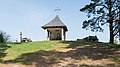
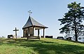
| Location | Golinhac, canton of Entraygues-sur-Truyère | ||||
 | |||||
Media in category "Chapelle Notre-Dame-des-Hauteurs"
The following 9 files are in this category, out of 9 total.
-
 Golinhac Notre-Dame-des-Hauteurs (1).jpg 3,190 × 2,393; 2.24 MB
-
 Golinhac Notre-Dame-des-Hauteurs inscription.jpg 3,264 × 2,448; 3.57 MB
-
 Golinhac Notre-Dame-des-Hauteurs vallée Lot.jpg 3,264 × 2,448; 4.44 MB
-
 Notre-Dame-des-Hauteurs chapel in Golinhac 01.jpg 5,201 × 2,883; 10.62 MB
-
 Notre-Dame-des-Hauteurs chapel in Golinhac 02.jpg 5,260 × 3,440; 12.19 MB
-
 Notre-Dame-des-Hauteurs chapel in Golinhac 03.jpg 5,152 × 5,017; 13.67 MB
-
 Notre-Dame-des-Hauteurs chapel in Golinhac 04.jpg 4,968 × 5,528; 16.92 MB
-
 Notre-Dame-des-Hauteurs chapel in Golinhac 05.jpg 5,498 × 3,330; 12.84 MB
-
 Notre-Dame-des-Hauteurs chapel in Golinhac 06.jpg 5,342 × 3,415; 12.36 MB


