Category:Chilwell
Jump to navigation
Jump to search
village in Nottinghamshire, UK | |||||
| Upload media | |||||
| Instance of | |||||
|---|---|---|---|---|---|
| Location | Broxtowe, Nottinghamshire, East Midlands, England | ||||
 | |||||
Subcategories
This category has the following 12 subcategories, out of 12 total.
2
B
- Bramcote Lane NET stop (2 F)
C
- Cator Lane NET stop (4 F)
- Cornmill, Chilwell (2 F)
E
- Eskdale Drive NET stop (2 F)
I
- Inham Road NET stop (2 F)
N
R
- Chilwell Retail Park (5 F)
T
- Trees in Chilwell (8 F)
Media in category "Chilwell"
The following 133 files are in this category, out of 133 total.
-
 5 seconds or 5 minutes - geograph.org.uk - 1478924.jpg 640 × 479; 92 KB
-
 Allied Preparations For D-day H35611.jpg 3,447 × 3,508; 3.12 MB
-
 Allotments, Cator Lane, Chilwell - geograph.org.uk - 921751.jpg 640 × 480; 105 KB
-
 Autumn colours in the park at Chilwell - geograph.org.uk - 1049327.jpg 640 × 480; 143 KB
-
 Autumnal Avenue - geograph.org.uk - 1050890.jpg 640 × 480; 150 KB
-
 Beeston Marsh, Attenborough Nature Reserve.jpg 1,024 × 768; 710 KB
-
 Blandford Road Bus Stop - geograph.org.uk - 1478882.jpg 479 × 640; 73 KB
-
 Brailsford Way Chilwell - geograph.org.uk - 1126793.jpg 640 × 480; 164 KB
-
 Carter Road Chilwell - geograph.org.uk - 1076187.jpg 640 × 480; 94 KB
-
 Castle College - Chilwell site - geograph.org.uk - 660535.jpg 427 × 640; 188 KB
-
 Chilwell Cemetery - geograph.org.uk - 1027298.jpg 640 × 480; 90 KB
-
 Chilwell Cemetery - geograph.org.uk - 1027300.jpg 640 × 480; 115 KB
-
 Chilwell Cemetery - geograph.org.uk - 55108.jpg 640 × 480; 95 KB
-
 Chilwell College House Junior School - geograph.org.uk - 1479049.jpg 640 × 479; 78 KB
-
 Chilwell Explosion Mass Graves plaques.jpg 640 × 568; 206 KB
-
 Chilwell Explosion Orchard Cottage plaque.jpg 1,280 × 962; 508 KB
-
 Chilwell Hall plaque.jpg 1,280 × 960; 511 KB
-
 Chilwell Hall subsidiary plaque.JPG 1,632 × 1,224; 745 KB
-
 Chilwell Manor Golf Course - geograph.org.uk - 1367139.jpg 640 × 479; 97 KB
-
 Chilwell Manor Golf Course - geograph.org.uk - 1367154.jpg 640 × 479; 121 KB
-
 Chilwell Manor Golf Course - geograph.org.uk - 1367156.jpg 640 × 479; 141 KB
-
 Chilwell Manor Golf Course - geograph.org.uk - 1367167.jpg 640 × 479; 112 KB
-
 Chilwell Manor Golf Course - geograph.org.uk - 1367183.jpg 640 × 479; 83 KB
-
 Chilwell Memorial Park - geograph.org.uk - 1158600.jpg 640 × 480; 150 KB
-
 Chilwell Memorial Park - geograph.org.uk - 1158615.jpg 640 × 480; 130 KB
-
 Chilwell Memorial Park - geograph.org.uk - 1158636.jpg 640 × 480; 93 KB
-
 Chilwell Road, Nos. 75 to 93 - geograph.org.uk - 1246936.jpg 640 × 480; 99 KB
-
 Chilwell School.jpg 4,032 × 3,024; 6.18 MB
-
 Chilwell Surgery - geograph.org.uk - 1059399.jpg 640 × 480; 140 KB
-
 Cottage at Chilwell, Notts.jpg 1,414 × 1,032; 334 KB
-
 Date stone, 177 High Road - geograph.org.uk - 1479010.jpg 640 × 479; 54 KB
-
 Ferndale Cottage, Chilwell.jpg 4,032 × 3,024; 3.78 MB
-
 Field Lane - geograph.org.uk - 1478915.jpg 640 × 479; 107 KB
-

-

-
 George Henry Hurt plaque.jpg 640 × 510; 175 KB
-
 Greenwood Court, Chilwell - geograph.org.uk - 1330245.jpg 640 × 480; 170 KB
-
 Gregory's Roses plaque.jpg 1,280 × 960; 549 KB
-
 Hallam's Lane - geograph.org.uk - 1478974.jpg 640 × 479; 80 KB
-
 History in a wall - Chilwell - geograph.org.uk - 628143.jpg 640 × 427; 134 KB
-
 Latest military transport^ - geograph.org.uk - 632122.jpg 640 × 427; 136 KB
-
 Line of Poplars - geograph.org.uk - 674154.jpg 640 × 434; 61 KB
-
 Loaded Barge and Tug - geograph.org.uk - 763759.jpg 640 × 420; 178 KB
-
 Newhall Drive, Chilwell - geograph.org.uk - 921706.jpg 640 × 480; 72 KB
-
 Parking area, Kirkbride Court - geograph.org.uk - 1478914.jpg 640 × 479; 84 KB
-
 Pedestrian access, Inham Nook - geograph.org.uk - 1478911.jpg 640 × 479; 116 KB
-
 Penrhyn Crescent - geograph.org.uk - 1478917.jpg 640 × 479; 87 KB
-
 Poplars - Chilwell - geograph.org.uk - 628622.jpg 640 × 427; 95 KB
-
 Post box NG9 605 - geograph.org.uk - 1478963.jpg 479 × 640; 107 KB
-
 Post box NG9 627 - geograph.org.uk - 1479026.jpg 479 × 640; 126 KB
-
 Ranson Road Chilwell - geograph.org.uk - 1072053.jpg 640 × 480; 90 KB
-
 Red Lion Cottage, Chilwell.jpg 4,032 × 3,024; 6.98 MB
-
 Redland Drive - geograph.org.uk - 1478952.jpg 640 × 479; 79 KB
-
 Richard Beckinsale plaque.jpg 1,280 × 960; 428 KB
-
 Road Leading to Chilwell Cemetery - geograph.org.uk - 1027295.jpg 640 × 480; 94 KB
-

-
 Row of Shops - geograph.org.uk - 1201994.jpg 640 × 480; 85 KB
-
 Simplex Knitting Company, Chilwell - geograph.org.uk - 697829.jpg 640 × 427; 221 KB
-
 SimplexKnittingCo.JPG 640 × 480; 86 KB
-
 Snowy Avenue at Work - geograph.org.uk - 1155353.jpg 640 × 480; 212 KB
-
 Snowy Avenue to Work - geograph.org.uk - 1155338.jpg 640 × 480; 222 KB
-
 SpecialistInArts.JPG 640 × 480; 78 KB
-
 St Barnabas, Barn Croft, Chilwell - geograph.org.uk - 777054.jpg 640 × 401; 128 KB
-
 Sunset Choppers - geograph.org.uk - 1073551.jpg 640 × 480; 37 KB
-
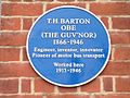 T H Barton plaque.jpg 1,280 × 960; 400 KB
-
 The Beekeeper - geograph.org.uk - 1065709.jpg 640 × 426; 61 KB
-
 The Beekeeper, Chilwell - geograph.org.uk - 661902.jpg 640 × 384; 199 KB
-
 The British Army in the United Kingdom 1939-45 H3086.jpg 800 × 603; 69 KB
-
 The British Army in the United Kingdom 1939-45 H37771.jpg 800 × 795; 77 KB
-
 The Cadland - geograph.org.uk - 1028672.jpg 640 × 426; 157 KB
-
 The Charlton Arms - geograph.org.uk - 1028666.jpg 640 × 426; 240 KB
-
 The Double Top - geograph.org.uk - 1008633.jpg 640 × 403; 194 KB
-
 The Double Top - geograph.org.uk - 1478828.jpg 640 × 479; 58 KB
-
 The Twitchell, off Chilwell High Road - geograph.org.uk - 1279661.jpg 480 × 640; 107 KB
-
-
 The Village Hotel Chilwell - geograph.org.uk - 1100132.jpg 640 × 480; 61 KB
-
 Three Shops from the 1930s - geograph.org.uk - 1439895.jpg 640 × 393; 61 KB
-
 Towards Chilwell from Common Lane - geograph.org.uk - 773815.jpg 640 × 265; 56 KB
-
 Traditional fencing, covered in frost - geograph.org.uk - 695525.jpg 416 × 640; 248 KB
-
 Trees on Chilwell Manor Golf Course - geograph.org.uk - 929167.jpg 640 × 480; 67 KB
-

-
 Virgin snow - geograph.org.uk - 1075195.jpg 640 × 480; 108 KB
-
 Weldbank Close - geograph.org.uk - 1478919.jpg 640 × 479; 120 KB
-
 Well trimmed Leylandii - Chilwell - geograph.org.uk - 632107.jpg 640 × 427; 121 KB
-
 Wheatgrass Farm, Chilwell - geograph.org.uk - 622427.jpg 640 × 480; 97 KB
-
 Whytehall Mews - geograph.org.uk - 1478958.jpg 640 × 479; 66 KB
-

-
 Woodland Grove, Chilwell - geograph.org.uk - 1439903.jpg 640 × 480; 97 KB
-
 Woodward Avenue - Chilwell - geograph.org.uk - 647671.jpg 640 × 427; 49 KB
-
 Woodward Avenue - Chilwell - geograph.org.uk - 647872.jpg 640 × 427; 62 KB
-
 Airedale Court, Chilwell - geograph.org.uk - 632141.jpg 640 × 365; 60 KB
-
 Aldene Court - geograph.org.uk - 1478186.jpg 640 × 479; 100 KB
-

-
 Audon Avenue, Chilwell - geograph.org.uk - 1800994.jpg 640 × 480; 53 KB
-
 Blandford Road - geograph.org.uk - 1478883.jpg 640 × 479; 113 KB
-
 Bramcote Lane - geograph.org.uk - 1478190.jpg 640 × 479; 66 KB
-
 Bramcote Lane - geograph.org.uk - 1478827.jpg 640 × 479; 88 KB
-
 Bramcote Lane Open Space - geograph.org.uk - 1478183.jpg 640 × 479; 99 KB
-
 Bramcote Lane Open Space - geograph.org.uk - 1478193.jpg 640 × 479; 75 KB
-
 Bramcote Lane open space - geograph.org.uk - 54395.jpg 640 × 480; 81 KB
-
 Bramcote Lane Open Space - geograph.org.uk - 661890.jpg 640 × 427; 267 KB
-
 Bridleway near Chilwell - geograph.org.uk - 622233.jpg 640 × 480; 87 KB
-
 Bridleway near Chilwell - geograph.org.uk - 622237.jpg 640 × 480; 90 KB
-
 Bye Pass Road - Chilwell - geograph.org.uk - 628090.jpg 427 × 640; 126 KB
-
 Bye Pass Road - Chilwell - geograph.org.uk - 628096.jpg 640 × 427; 119 KB
-
 Bye Pass Road - Chilwell - geograph.org.uk - 628128.jpg 477 × 640; 125 KB
-
 Car Wash on Chilwell High Road - geograph.org.uk - 1246947.jpg 640 × 480; 94 KB
-
 Carr willow - geograph.org.uk - 54024.jpg 640 × 480; 82 KB
-
 Castle College - Chilwell site - geograph.org.uk - 1018001.jpg 426 × 640; 47 KB
-
 Chilwell footbridge (3) - geograph.org.uk - 677771.jpg 640 × 315; 163 KB
-
 Chilwell Footbridge - geograph.org.uk - 54383.jpg 640 × 480; 88 KB
-
 Chilwell footbridge 2 - geograph.org.uk - 628132.jpg 427 × 640; 96 KB
-
 Depot Corner - Chilwell - geograph.org.uk - 628110.jpg 640 × 422; 84 KB
-
 Depot Corner - Chilwell - geograph.org.uk - 628121.jpg 640 × 385; 93 KB
-
 Eskdale Drive - geograph.org.uk - 1404549.jpg 640 × 436; 79 KB
-
 Eskdale Drive - geograph.org.uk - 1404554.jpg 640 × 439; 67 KB
-
 Ex Long Eaton Textile Services (1) - geograph.org.uk - 686241.jpg 640 × 427; 202 KB
-
 Ex Long Eaton Textile Services (2) - geograph.org.uk - 686255.jpg 640 × 427; 235 KB
-
 Field Lane, Chilwell - geograph.org.uk - 632131.jpg 427 × 640; 117 KB
-
 Field, Hedge and Flats, Chilwell - geograph.org.uk - 777063.jpg 640 × 427; 124 KB
-
 Fruit trees near Bardill's Centre - geograph.org.uk - 622228.jpg 640 × 480; 93 KB
-
 Ghost House Lane - Chilwell - geograph.org.uk - 632109.jpg 640 × 427; 109 KB
-
 Hawthorn and Ivy - geograph.org.uk - 628614.jpg 427 × 640; 167 KB
-
 Hedgerow and meadow - geograph.org.uk - 54388.jpg 640 × 480; 112 KB
-
 Inham Nook, Chilwell - geograph.org.uk - 777051.jpg 640 × 423; 158 KB
-
-
 Long Eaton Textile Services (1) - geograph.org.uk - 677746.jpg 640 × 427; 207 KB
-
 Long Eaton Textile Services (2) - geograph.org.uk - 677748.jpg 640 × 427; 222 KB
-
 Path across Chilwell Manor Golf Club - geograph.org.uk - 628519.jpg 640 × 427; 97 KB
-
 Path across Chilwell Manor Golf Club - geograph.org.uk - 628522.jpg 640 × 427; 109 KB
-
 Rock and willow - geograph.org.uk - 202648.jpg 480 × 637; 311 KB
-
 Scrivelsby Gardens, Chilwell - geograph.org.uk - 677782.jpg 640 × 427; 191 KB
-
 Sycamore roots and sandstone - geograph.org.uk - 54404.jpg 640 × 480; 132 KB


_-_geograph.org.uk_-_677771.jpg)


_-_geograph.org.uk_-_686241.jpg)
_-_geograph.org.uk_-_686255.jpg)


_-_geograph.org.uk_-_677746.jpg)
_-_geograph.org.uk_-_677748.jpg)


