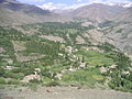
Category:Chitral District
Jump to navigation
Jump to search
former district of Khyber Pakhtunkhwa, Pakistan _14.jpg)  | |||||
| Upload media | |||||
| Instance of | |||||
|---|---|---|---|---|---|
| Location | Malakand Division, Khyber Pakhtunkhwa, Pakistan | ||||
| Capital | |||||
| Inception |
| ||||
| Dissolved, abolished or demolished date |
| ||||
| Area |
| ||||
 | |||||
English: The Chitral District is a former district of Khyber Pakhtunkhwa, northern Pakistan. In 2018, it was divided into two separate districts, see
Subcategories
This category has the following 26 subcategories, out of 26 total.
A
B
- Beshqir Payeen (7 F)
- Broke Village (3 F)
C
- Chitral rocks (1 F)
D
- Darkot Glacier (9 F)
- Denin Valley (1 F)
- Duurzach Valley (1 F)
F
G
- Golain Valley (5 F)
J
- Joghor Gol (7 F)
K
- Kalash mountains (3 F)
- Khowar (6 F)
L
M
- Mosta japendeh, Chitral (4 F)
O
P
R
- Road to Chitral (7 F)
S
- Shandur (17 F)
- Streams in Chitral (4 F)
U
V
W
- Waterfalls in Chitral (1 F)
- Winter in Chitral (1 F)
Media in category "Chitral District"
The following 200 files are in this category, out of 308 total.
(previous page) (next page)-
 Chitral NWFP.svg 1,000 × 1,075; 138 KB
-
 Khyber Pakhtunkhwa Districts Chitral.svg 2,682 × 4,166; 493 KB
-
 Pakistan - Khyber Pakhtunkhwa - Chitral.svg 654 × 841; 207 KB
-

-
 A beautiful view of Khonartek Khot Chitral Khyber Pakhtunkhwa Pakistan.JPG 2,048 × 1,536; 697 KB
-
 A beautiful view of Puchung Torkhow Chitral Pakistan.JPG 2,048 × 1,536; 628 KB
-
 A ibex.JPG 3,648 × 2,432; 3.5 MB
-
 A random place in chitral.jpg 2,592 × 1,944; 1.18 MB
-
 A scenic view, chitral.jpg 640 × 640; 98 KB
-
 A stream of enchantment,chitral.jpg 1,080 × 2,199; 928 KB
-
 A view of Shadandur Khot Valley Torkhow Chitral KPK Pakistan.jpg 2,048 × 1,536; 682 KB
-
 A view of Terich Mir Peak Chitral Pakistan.JPG 2,048 × 1,536; 698 KB
-
 A waterfall on the way to chitral.jpg 640 × 640; 187 KB
-
 Above Charun - panoramio.jpg 2,816 × 2,112; 960 KB
-
 Akram Ovir Arkari Chitral Pakistan.jpg 3,072 × 2,304; 2.91 MB
-
 Akram1 Ovir Arkari Chitral Pakistan.jpg 2,592 × 1,944; 1.86 MB
-
 Aman ullah.jpg 287 × 350; 18 KB
-
 An old Kalash woman in tradational outfit.jpg 3,824 × 4,780; 9.16 MB
-
 Andakhtti Chitral.jpg 1,536 × 2,048; 1.26 MB
-
 Arandu valley.jpg 425 × 269; 61 KB
-
 Ayun fort inn chitral.jpg 6,000 × 4,000; 10.12 MB
-
 Baha Chttat Kokoesh Lake No 1 Langar Valley Chitral - panoramio.jpg 960 × 719; 311 KB
-
 Baha Chttat Kokoesh Lake No3 - panoramio.jpg 960 × 719; 391 KB
-
 Bamansoor chitral.jpg 5,456 × 3,632; 5.31 MB
-
 Bamboret (27410943874).jpg 2,250 × 1,500; 1.95 MB
-
 Bashkargol Stream.jpg 5,184 × 2,916; 4.5 MB
-
 Beauty of Chitral.jpg 960 × 637; 116 KB
-
 Brahmi Inscription with Buddhist Stupa, Archaeological Site - panoramio.jpg 2,816 × 2,112; 1.8 MB
-
 Bridge to Bamboret and Rambur Valley (27922736142).jpg 2,250 × 1,500; 4.02 MB
-
 Brigadier General Herbert Colborne Nanton (6282834460).jpg 514 × 800; 36 KB
-
 Canyon of calm.jpg 640 × 480; 274 KB
-
 Chakast Mountain, charun oweer.jpg 4,000 × 2,666; 10.56 MB
-
 Channi Chitral.jpg 4,432 × 624; 471 KB
-
 Charun Oveer from Charun Side - panoramio.jpg 2,816 × 2,112; 1.08 MB
-
 Charun owir.jpg 6,000 × 4,000; 11.16 MB
-
 Checkpost at River Swat interchange for Chitral.jpg 3,264 × 2,448; 1.63 MB
-
 Chikaar, District Chitral, Khyber Pakhtonkhwa, Pakistan.jpg 3,888 × 2,592; 2.43 MB
-
 Chilam Gosh Festival, Chitral, Pakistan.jpg 4,776 × 2,797; 16.69 MB
-
 Childrens' Collections - panoramio.jpg 2,816 × 2,112; 1.97 MB
-
 Chital atahk near terichmir base camp.jpg 5,456 × 3,632; 4.81 MB
-
 Chitra PKl2.JPG 1,600 × 1,200; 330 KB
-
 Chitra Settlement.JPG 3,264 × 4,928; 1.43 MB
-
 Chitraal.jpg 4,160 × 3,120; 4.19 MB
-
 Chitral ( on way to Shandur ) 2.jpg 2,048 × 1,536; 561 KB
-
 Chitral - panoramio.jpg 640 × 480; 128 KB
-
 Chitral 01 Pakistan.jpg 960 × 960; 189 KB
-
 Chitral 02 Pakistan.jpg 960 × 720; 116 KB
-
 Chitral 05 Pakistan.jpg 960 × 720; 157 KB
-
 Chitral 06 Pakistan.jpg 720 × 720; 142 KB
-
 Chitral 07 Pakistan.jpg 960 × 540; 127 KB
-
 Chitral 09 Pakistan.jpg 640 × 480; 57 KB
-
 Chitral 11 Pakistan.jpg 640 × 480; 50 KB
-
 Chitral 1234.jpg 2,560 × 1,920; 2.23 MB
-
 Chitral 1238.jpg 2,560 × 1,920; 1.78 MB
-
 Chitral 1239.jpg 2,560 × 1,920; 1.57 MB
-
 Chitral 1240.jpg 2,560 × 1,920; 2.37 MB
-
 Chitral 1241.jpg 2,560 × 1,920; 2.31 MB
-
 Chitral 44 Pakistan.jpg 960 × 960; 165 KB
-
 Chitral 77 Pakistan.jpg 640 × 854; 83 KB
-
 Chitral along side River Kunar.jpg 16,382 × 3,628; 16.81 MB
-
 Chitral chashma.jpg 2,048 × 1,536; 1,006 KB
-
 Chitral City (27410923324).jpg 2,250 × 1,500; 1.53 MB
-
 Chitral District is mostly mountains and glaciers.jpg 5,184 × 2,624; 5.9 MB
-
 Chitral District landscape, 2014.jpg 2,560 × 1,920; 2.27 MB
-
 Chitral FL.jpg 3,264 × 4,928; 1.36 MB
-
 Chitral Fort, from the South, 1895.jpg 600 × 393; 32 KB
-
 Chitral Green in spring.JPG 3,648 × 2,432; 3.54 MB
-
 Chitral Haddid - panoramio - Haddid Uddin.jpg 640 × 480; 56 KB
-
 Chitral Haddid - panoramio.jpg 640 × 480; 57 KB
-
 Chitral High Court logo.png 970 × 990; 703 KB
-
 Chitral in summer.JPG 2,288 × 1,712; 774 KB
-
 Chitral in Winter.jpg 1,242 × 892; 260 KB
-
 Chitral Khyber PK.jpg 722 × 600; 90 KB
-
 Chitral kpk,.jpg 1,500 × 1,000; 305 KB
-
 Chitral KPK.JPG 4,928 × 3,264; 8.45 MB
-
 Chitral kpk.jpg 1,500 × 1,000; 419 KB
-
 Chitral Logo.jpg 300 × 300; 28 KB
-
 Chitral Mountains, Pakistan.jpg 6,000 × 4,000; 2.27 MB
-
 Chitral Pakistan - panoramio (1).jpg 4,068 × 1,536; 1.42 MB
-
 Chitral Pakistan Haddid - panoramio - Haddid Uddin (1).jpg 640 × 480; 48 KB
-
 Chitral Pakistan Haddid - panoramio - Haddid Uddin (2).jpg 640 × 480; 44 KB
-
 Chitral Pakistan Haddid - panoramio - Haddid Uddin.jpg 640 × 480; 49 KB
-
 Chitral PK1.JPG 1,600 × 1,200; 339 KB
-
 Chitral PK3.JPG 1,600 × 1,200; 333 KB
-
 Chitral River near Ayun (27946866901).jpg 2,250 × 1,500; 2.47 MB
-
 Chitral Settlement FL.jpg 4,928 × 3,264; 1.82 MB
-
 Chitral Settlement.JPG 4,928 × 3,264; 1.89 MB
-
 Chitral Town, KPK, Pakistan.jpg 4,288 × 2,848; 11.8 MB
-
 Chitral View.jpg 494 × 296; 39 KB
-
 Chitral Water site.jpg 343 × 206; 19 KB
-
 Chitral, Northern Pakistan.jpg 1,242 × 1,202; 648 KB
-
 Chitral, Pakistan - panoramio.jpg 3,072 × 2,304; 4.41 MB
-
 Chitral, Pakistan 2 !.jpg 1,800 × 1,207; 2.26 MB
-
 Chitral,Khilash,KPK.JPG 4,928 × 3,264; 8.59 MB
-
 Chitral.JPG 1,242 × 644; 343 KB
-
 ChitralDiaries 01.jpg 5,184 × 3,456; 2.01 MB
-
 ChitralDiaries 02.jpg 4,504 × 3,101; 1.83 MB
-
 ChitralDiaries 06.jpg 5,184 × 3,456; 1.46 MB
-
 ChitralDiaries 07.jpg 5,184 × 3,456; 2.06 MB
-
 Chitralscene.JPG 640 × 480; 98 KB
-
 Chitral’s beauty 01.jpg 960 × 350; 102 KB
-
 Chitral’s beauty 02.jpg 960 × 350; 108 KB
-
 Chitral’s beauty 03.jpg 680 × 437; 95 KB
-
 Chitriver.JPG 480 × 640; 22 KB
-
 Chtral Deer.JPG 4,608 × 3,072; 6.95 MB
-
 Clouds and mountains, chitral.jpg 640 × 640; 98 KB
-
 Clouds and Mountainss.jpg 2,720 × 2,720; 2.01 MB
-
 Cold Evening at Chitral.jpg 1,000 × 664; 102 KB
-
 Cold water stream.jpg 640 × 640; 182 KB
-
 Colours of Kalash.jpg 1,280 × 1,140; 328 KB
-
 Confluence of Laspur River (right) and Yarkhun River (left) at Mastuj Town.jpg 4,032 × 3,024; 3.64 MB
-
 Cool winter.jpg 480 × 635; 30 KB
-
 Cumulus congestus clouds in Pakistan in Chitra.jpg 2,560 × 1,920; 1.14 MB
-
 Cumulus congestus clouds in Pakistan, Chitral.jpg 2,560 × 1,920; 1.12 MB
-
 Daneen Chitral.jpg 4,000 × 2,666; 12.82 MB
-
 Deosai Plains FFL.jpg 4,928 × 3,264; 1,012 KB
-
 Deosai Plains FLL.jpg 4,928 × 3,264; 1.58 MB
-
 Drummer boy Chitral.jpg 1,200 × 1,600; 173 KB
-

-
 Four Layers of Mountains.jpg 2,720 × 2,720; 1.94 MB
-
 Fresh Water Spring in Pakistan.jpg 2,448 × 2,448; 1.37 MB
-
 Gasht Chitral.jpg 3,264 × 1,836; 3.47 MB
-
 Ghochhar sar.jpg 3,264 × 2,448; 1.51 MB
-
 Golan entry point.JPG 4,608 × 3,456; 5.54 MB
-
 Golen Chitral.JPG 448 × 336; 102 KB
-
 Golen Valley.jpg 5,312 × 2,988; 13.11 MB
-
 Golian Valley Chitral Pakistan.jpg 4,496 × 3,000; 5.16 MB
-
 Gpanicht.jpg 2,448 × 3,264; 2.84 MB
-
 Grass Lands over Hills.jpg 3,072 × 3,072; 3.16 MB
-
 Green Places in Chitral.jpg 960 × 539; 81 KB
-
 Greenery with water.JPG 2,304 × 3,072; 2.43 MB
-
 Gupis Northern Area Chitral.jpg 640 × 480; 168 KB
-
 Gupis1 Northern Area Chitral.jpg 640 × 480; 168 KB
-
 Gupis2 Northern Area Chitral.jpg 640 × 480; 170 KB
-
 Habitat in woods.jpg 640 × 480; 427 KB
-
 Harchin Laspur.jpg 1,080 × 810; 691 KB
-
 Harchin.jpg 1,280 × 960; 572 KB
-
 Hardworkers.jpg 2,448 × 2,448; 2.45 MB
-
 High mountain passes in Chitral, Pakistan.jpg 3,960 × 2,102; 7.59 MB
-
 Highest peak of Hindukush.jpg 1,536 × 2,048; 161 KB
-
 Highlands in Chitral.JPG 3,264 × 2,448; 2.2 MB
-
 Hiking 1.jpg 5,184 × 3,456; 7.72 MB
-
 Hiking 2.jpg 5,184 × 3,456; 6.31 MB
-
 Hiking 3.jpg 5,184 × 3,456; 5.71 MB
-
 Hills beauty.JPG 3,072 × 2,304; 2.63 MB
-
 Hot Spring Chitral.JPG 4,288 × 3,216; 2.57 MB
-
 Houses of Rumbur (27989805746).jpg 2,250 × 1,500; 1.76 MB
-
 In hotel enjoying tea at Garam chashma, chitral.jpg 3,120 × 4,160; 3.69 MB
-
 Insect In Room At Village Jughoor,Chitral,KPK.jpg 2,048 × 1,365; 152 KB
-
 Jheel Golen Chitral.jpg 2,048 × 1,360; 525 KB
-
 Joy for ever.jpg 640 × 480; 212 KB
-
 Junalkoch.jpg 4,000 × 2,666; 10.81 MB
-
 Jungle Golen Chitral 2.jpg 640 × 480; 135 KB
-
 Jungle Golen Chitral 3.jpg 640 × 480; 143 KB
-
 Jungle Golen Chitral 4.jpg 2,048 × 1,360; 663 KB
-
 Jungle Golen Gol, Chitral, KPK, Pakistan.jpg 4,235 × 2,813; 8.74 MB
-
 Kalaash valley cultural dress.jpg 6,016 × 4,016; 16.36 MB
-
 Kalash Tribe- Chitral district.jpg 2,406 × 1,600; 2.29 MB
-
 Kalash valley cultural outfit.jpg 4,016 × 6,016; 17.92 MB
-
 Karambar Lake-Brogil Chitral.jpg 1,800 × 1,200; 1.99 MB
-
 Kashkan Lake Kumrat Backside area - panoramio.jpg 1,024 × 683; 173 KB
-
 Kelashi Girls - panoramio.jpg 720 × 540; 195 KB
-
 Khot valley.jpg 1,070 × 803; 749 KB
-
 Khowar.jpg 556 × 720; 8 KB
-
 Khowar.png 1,024 × 768; 25 KB
-
 Kuragh Village (27922740502).jpg 2,250 × 1,500; 1.05 MB
-
 Langaar Shandur.jpg 4,272 × 2,848; 4.49 MB
-
 Langar Shandoor.jpg 4,272 × 2,848; 5.26 MB
-
 Langar Shandur.jpg 4,272 × 2,848; 5.11 MB
-
 Lasht Village (27989760716).jpg 2,250 × 1,500; 2.9 MB
-
 Laspur Chitral.jpg 4,272 × 2,848; 3.88 MB
-
 Laspur Valley Chitral.JPG 3,648 × 2,736; 4.14 MB
-
 Laspur Vally.JPG 4,288 × 3,216; 2.61 MB
-
 Laspur VIllage (27922298802).jpg 2,250 × 1,500; 2.68 MB
-
 Last Winters in KPK.JPG 3,264 × 2,448; 5.43 MB
-
 Last Winters.jpg 3,264 × 2,448; 2.79 MB
-
 Lawari Top Road.jpg 2,160 × 2,160; 1.81 MB
-
 Lawari Top The way Chitral.jpg 4,128 × 3,096; 3.8 MB
-
 Layers of Mountain.jpg 2,448 × 2,448; 2 MB
-
 Leading to Paradise.jpg 640 × 480; 285 KB
-
 Lowari tunnel, Chitral, Pakistan.jpg 2,560 × 1,440; 1.66 MB
-
 Lower Balim Chitral.jpg 4,272 × 2,848; 5.06 MB
-
 Lwari Pass - panoramio.jpg 720 × 540; 112 KB
-
 Lwari Top Chitral Viewpoint - panoramio.jpg 432 × 576; 71 KB
-
 Madaklasht Chitral.JPG 1,920 × 1,080; 914 KB
-
 Madaklasht Pass Upper Chitral - panoramio.jpg 960 × 640; 175 KB
-
 Madaklasht Valley Upper Chitral - panoramio - Ahmad Ali Khan (2).jpg 960 × 720; 149 KB
-
 Madaklasht Valley Upper Chitral - panoramio - Ahmad Ali Khan.jpg 960 × 640; 274 KB
-
 Madaklasht, Chitral.jpg 1,242 × 1,211; 538 KB
-
 Malberry collected.jpg 2,160 × 2,160; 2 MB
-
 Marandeh Valley Khot Chitral Pakistan.JPG 2,048 × 1,536; 666 KB
-
 Mastuj (27410528604).jpg 2,250 × 1,500; 1.44 MB
-
 Mastuj Tehsil، Pakistan - panoramio.jpg 5,184 × 3,456; 8.97 MB
-
 Mirkhani 2.jpg 810 × 1,440; 318 KB
-
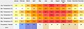 Mirkhani climate chart.jpg 1,800 × 630; 202 KB
-
 Mirkhani.jpg 640 × 480; 208 KB
-
 Mogh nizh.jpg 640 × 480; 68 KB
-
-
 Moon over the peaks.jpg 2,448 × 2,448; 2.08 MB
-
 Mountains beauty.JPG 3,072 × 2,304; 2.35 MB


.jpg)


.jpg)
.jpg)


_2.jpg)


.jpg)


.jpg)
.jpg)


.jpg)


_and_Yarkhun_River_(left)_at_Mastuj_Town.jpg)


.jpg)


.jpg)


.jpg)


.jpg)


.jpg)


.jpg)


.jpg)