Category:Church House, Hanover Street
Jump to navigation
Jump to search
| Object location | | View all coordinates using: OpenStreetMap |
|---|
house in Liverpool, Merseyside, England, UK  | |||||
| Upload media | |||||
| Instance of | |||||
|---|---|---|---|---|---|
| Location | Liverpool, Merseyside, North West England, England | ||||
| Heritage designation |
| ||||
 | |||||
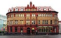
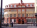
1870s building, formerly the Merseyside Mission to Seamen and as such helpfully close to the Sailors' Home across Paradise Street.
Media in category "Church House, Hanover Street"
The following 14 files are in this category, out of 14 total.
-
 Architectural Detail - Liverpool - England - 05 (27521438953).jpg 2,736 × 3,648; 4.14 MB
-
 Church House, Hanover Street - geograph.org.uk - 2813279.jpg 640 × 480; 69 KB
-
 Church House, Hanover Street, 2018-1.jpg 5,018 × 3,119; 8.59 MB
-
 Church House, Hanover Street, 2018-2.jpg 4,014 × 3,227; 7.12 MB
-
 Church House, Hanover Street, 2018-3.jpg 3,349 × 4,617; 6.73 MB
-
 Church House, Hanover Street, Liverpool - geograph.org.uk - 2853475.jpg 640 × 492; 200 KB
-
 Church House, Hanover Street, Liverpool.jpg 2,048 × 1,536; 593 KB
-
 Church House, Liverpool - geograph.org.uk - 1138153.jpg 640 × 480; 79 KB
-
 Church House, Liverpool - geograph.org.uk - 2976380.jpg 640 × 480; 51 KB
-
 Church House, Liverpool 1.jpg 1,984 × 1,488; 669 KB
-
 Church House, Liverpool 2.jpg 1,488 × 1,984; 597 KB
-
 Hanover Street, Paradise Street (130196938).jpg 640 × 441; 161 KB
-
 Liverpool building Hanover Street.jpg 1,178 × 1,562; 1.26 MB
-

.jpg)


.jpg)

.jpg)