Category:Church in Abbendorf (Prignitz)
Jump to navigation
Jump to search
| Object location | | View all coordinates using: OpenStreetMap |
|---|
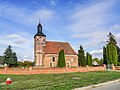
This is the category of the Brandenburger Baudenkmal (cultural heritage monument) with the ID 09160545 (Wikidata)
|
church building in Brandenburg state , Germany  | |||||
| Upload media | |||||
| Instance of | |||||
|---|---|---|---|---|---|
| Location | |||||
| Heritage designation | |||||
 | |||||
Media in category "Church in Abbendorf (Prignitz)"
The following 4 files are in this category, out of 4 total.
-
 Abbendorf Kirche.jpg 3,575 × 2,681; 4.88 MB
-
 Church clock of Abbendorf.jpg 4,000 × 3,000; 8.66 MB
-
 Kirche Abbendorf.jpg 3,872 × 2,592; 4.05 MB
-
 Ruehstaedt Abbendorf Kirche.jpg 3,648 × 2,736; 2.93 MB


