Category:Church in Fürstenwerder
Jump to navigation
Jump to search
| Object location | | View all coordinates using: OpenStreetMap |
|---|
 | |||||
| Upload media | |||||
| Instance of | |||||
|---|---|---|---|---|---|
| Location | Fürstenwerder, Nordwestuckermark, Uckermark District, Brandenburg, Germany | ||||
| Heritage designation | |||||
 | |||||
This is the category of the Brandenburger Baudenkmal (cultural heritage monument) with the ID 09130044 (Wikidata)
|
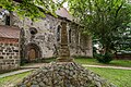
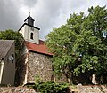
Deutsch: Ansichten der Kirche in Fürstenwerder, Gemeinde Nordwestuckermark, Landkreis Uckermark, Land Brandenburg, Deutschland.
English: Pictures of the church in Fürstenwerder, Nordwestuckermark municipality, Uckermark district, Brandenburg state, Germany
Français : Photos de l'église à Fürstenwerder, commune de Nordwestuckermark, arrondissement de Uckermark, état fédéral de Brandebourg, Allemagne
Media in category "Church in Fürstenwerder"
The following 6 files are in this category, out of 6 total.
-
 Fuerstenwerder 06 18 08 jiw.jpg 1,920 × 1,280; 1,007 KB
-
 Fuerstenwerder 06 18 11 jiw.jpg 1,920 × 1,280; 980 KB
-
 Heilandskirche Fürstenwerder 2018 Infotafel.jpg 3,564 × 4,802; 5.97 MB
-
 Heilandskirche Fürstenwerder 2018 Nordportal.jpg 3,648 × 4,864; 7.17 MB
-
 Heilandskirche Fürstenwerder 2018 SW.jpg 5,385 × 4,693; 12.19 MB
-
 Heilandskirche Fürstenwerder 2018 Westportal.jpg 4,760 × 6,355; 13.66 MB


