Category:Church in Güterberg (Uckermark)
Jump to navigation
Jump to search
| Object location | | View all coordinates using: OpenStreetMap |
|---|
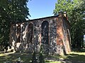
church building in Uckermark, Brandenburg state, Germany  | |||||
| Upload media | |||||
| Instance of | |||||
|---|---|---|---|---|---|
| Location | Güterberg, Uckerland, Uckermark District, Brandenburg, Germany | ||||
| Heritage designation | |||||
 | |||||
This is the category of the Brandenburger Baudenkmal (cultural heritage monument) with the ID 09130493 (Wikidata)
|
English: Church in Güterberg, Uckerland municipality, Uckermark district, Brandenburg state, Germany
Deutsch: Kirche in Güterberg, Gemeinde Uckerland, Landkreis Uckermark, Land Brandenburg, Deutschland.
Français : Église de Güterberg, commune de Uckerland, arrondissement Uckermark, état fédéral de Brandebourg, Allemagne
Media in category "Church in Güterberg (Uckermark)"
The following 12 files are in this category, out of 12 total.
-
 Dorfkirche Güterberg 2017 Belfry.jpg 3,648 × 4,864; 6.77 MB
-
 Dorfkirche Güterberg 2017 E.jpg 4,864 × 3,648; 6.11 MB
-
 Dorfkirche Güterberg 2017 NW.jpg 4,864 × 3,648; 8.55 MB
-
 Dorfkirche Güterberg 2017 S.jpg 4,864 × 3,648; 8.26 MB
-
 Dorfkirche Güterberg 2017 SW.jpg 3,648 × 4,864; 7.65 MB
-
 Dorfkirche Güterberg 2017 W.jpg 4,864 × 3,648; 8.02 MB
-
 Dorfkirche Güterberg Blick ins Kirchenschiff.jpg 4,032 × 3,024; 2.21 MB
-
 Dorfkirche Güterberg Glockenstuhl.jpg 4,032 × 3,024; 3.98 MB
-
 Dorfkirche Güterberg Nordansicht.jpg 4,032 × 3,024; 4.5 MB
-
 Dorfkirche Güterberg Ostansicht.jpg 3,024 × 4,032; 4.62 MB
-
 Dorfkirche Güterberg Südostansicht.jpg 4,032 × 3,024; 4.11 MB
-
 Dorfkirche Güterberg Westportal.jpg 3,024 × 4,032; 4.15 MB


