Category:Church in Gellmersdorf
Jump to navigation
Jump to search
| Object location | | View all coordinates using: OpenStreetMap |
|---|
 | |||||
| Upload media | |||||
| Instance of | |||||
|---|---|---|---|---|---|
| Location | Gellmersdorf, Angermünde, Uckermark District, Brandenburg, Germany | ||||
| Heritage designation | |||||
 | |||||
This is the category of the Brandenburger Baudenkmal (cultural heritage monument) with the ID 09130450 (Wikidata)
|
English: Church in Gellmersdorf, Angermünde municipality, Uckermark district, Brandenburg state, Germany
Deutsch: Kirche in Gellmersdorf, Stadt Angermünde, Landkreis Uckermark, Land Brandenburg, Deutschland.
Français : Église de Gellmersdorf, ville de Angermünde, arrondissement Uckermark, état fédéral de Brandebourg, Allemagne
Media in category "Church in Gellmersdorf"
The following 15 files are in this category, out of 15 total.
-
 Angermünder Nachrichten 22. Dezember 2023.png 1,330 × 850; 657 KB
-
 Dorfkirche Gellmersdorf 2018 N.jpg 5,289 × 4,564; 12.66 MB
-
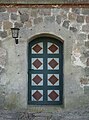 Dorfkirche Gellmersdorf 2018 Nordportal.jpg 3,552 × 4,792; 6.6 MB
-
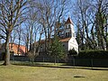 Dorfkirche Gellmersdorf 2018 NW.jpg 4,864 × 3,648; 9.4 MB
-
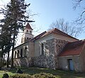
 Dorfkirche Gellmersdorf 2018 S.jpg 5,295 × 4,799; 13.68 MB
-
 Dorfkirche Gellmersdorf 2018 SE.jpg 4,928 × 4,523; 8.82 MB
-
 Dorfkirche Gellmersdorf 2018 Turmhaube.jpg 3,648 × 4,864; 6.33 MB
-
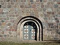 Dorfkirche Gellmersdorf 2018 Westportal.jpg 4,474 × 3,359; 8.41 MB
-
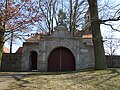 Friedhofsportal Gellmersdorf 2018 N.jpg 4,864 × 3,648; 7.98 MB
-
 Gellmersdorf 04-14.jpg 3,543 × 2,657; 6.87 MB
-
 Gellmersdorf Stolzenhagen 04-17.jpg 1,575 × 1,181; 1.24 MB
-
 Glockenguss 20.10.2023.jpg 2,362 × 1,326; 1.44 MB
-
 Kirche GL 04-18.jpg 1,280 × 960; 582 KB
-
 KircheGellmersdorf5 jiw.jpg 2,000 × 2,273; 2.06 MB
-
 Zwei Glocken Gellmersdorf 12-23.jpg 2,362 × 1,063; 1.63 MB


