Category:Church in Grünow (bei Prenzlau)
Jump to navigation
Jump to search
| Object location | | View all coordinates using: OpenStreetMap |
|---|
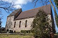
_2018_S.jpg) | |||||
| Upload media | |||||
| Instance of | |||||
|---|---|---|---|---|---|
| Location | Grünow, Uckermark District, Brandenburg, Germany | ||||
| Heritage designation | |||||
 | |||||
This is the category of the Brandenburger Baudenkmal (cultural heritage monument) with the ID 09130485 (Wikidata)
|
Deutsch: Ansichten der Kirche in Grünow, Gemeinde Grünow, Landkreis Uckermark, Land Brandenburg, Deutschland.
English: Pictures of the church in Grünow, Grünow municipality, Uckermark district, Brandenburg state, Germany
Français : Photos de l'église à Grünow, commune de Grünow, arrondissement de Uckermark, état fédéral de Brandebourg, Allemagne
Media in category "Church in Grünow (bei Prenzlau)"
The following 9 files are in this category, out of 9 total.
-
 Dorfkirche Grünow (bei Prenzlau) 2018 NE.jpg 4,864 × 3,648; 7.9 MB
-
 Dorfkirche Grünow (bei Prenzlau) 2018 Nordportal.jpg 3,648 × 4,864; 8.51 MB
-
 Dorfkirche Grünow (bei Prenzlau) 2018 NW.jpg 4,989 × 4,367; 6.91 MB
-
 Dorfkirche Grünow (bei Prenzlau) 2018 S.jpg 5,881 × 4,879; 15.42 MB
-
 Dorfkirche Grünow (bei Prenzlau) 2018 SE.jpg 5,093 × 4,750; 10.18 MB
-
 Dorfkirche Grünow (bei Prenzlau) 2018 SSE.jpg 5,419 × 3,552; 10.91 MB
-
 Dorfkirche Grünow (bei Prenzlau) 2018 vermauertes Nordportal.jpg 3,648 × 4,864; 7.4 MB
-
 Dorfkirche Grünow (bei Prenzlau) 2018 Westportal.jpg 3,582 × 4,816; 9.13 MB
-
 Gruenow 03 18 05 jiw.jpg 1,920 × 1,280; 947 KB
_2018_NE.jpg)
_2018_Nordportal.jpg)
_2018_NW.jpg)
_2018_SE.jpg)
_2018_SSE.jpg)
_2018_vermauertes_Nordportal.jpg)
_2018_Westportal.jpg)
