Category:Church in Grabow (Kümmernitztal)
Jump to navigation
Jump to search
| Object location | | View all coordinates using: OpenStreetMap |
|---|
This is the category of the Brandenburger Baudenkmal (cultural heritage monument) with the ID 09160138 (Wikidata)
|
_2017_SE.jpg) | |||||
| Upload media | |||||
| Instance of | |||||
|---|---|---|---|---|---|
| Location | Grabow (Kümmernitztal), Kümmernitztal, Prignitz District, Brandenburg, Germany | ||||
| Heritage designation | |||||
 | |||||
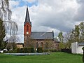
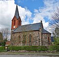
English: Pictures of the church in Grabow, Kümmernitztal municipality, Prignitz district, Brandenburg state, Germany
Deutsch: Bilder der Kirche in Grabow, Gemeinde Kümmernitztal, Landkreis Prignitz, Land Brandenburg, Deutschland.
Français : Photos de l'église à Grabow, commune de Kümmernitztal, arrondissement de Prignitz, état fédéral de Brandebourg, Allemagne
Media in category "Church in Grabow (Kümmernitztal)"
The following 6 files are in this category, out of 6 total.
-
 Dorfkirche Grabow (Kümmernitztal) 2017 NE.jpg 4,103 × 4,206; 6.29 MB
-
 Dorfkirche Grabow (Kümmernitztal) 2017 NW.jpg 3,602 × 4,830; 5.92 MB
-
 Dorfkirche Grabow (Kümmernitztal) 2017 Portal W.jpg 3,648 × 4,864; 5.53 MB
-
 Dorfkirche Grabow (Kümmernitztal) 2017 S.jpg 4,864 × 3,648; 6.95 MB
-
 Dorfkirche Grabow (Kümmernitztal) 2017 SE.jpg 4,780 × 4,581; 9.08 MB
-
 Dorfkirche Grabow (Kümmernitztal) 2017 SW.jpg 3,648 × 4,864; 5.79 MB
_2017_NE.jpg)
_2017_NW.jpg)
_2017_Portal_W.jpg)
_2017_S.jpg)
_2017_SW.jpg)