Category:Church in Sahryń
Jump to navigation
Jump to search
| Object location | | View all coordinates using: OpenStreetMap |
|---|
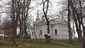
church building in Sahryń, Poland  | |||||
| Upload media | |||||
| Instance of | |||||
|---|---|---|---|---|---|
| Named after | |||||
| Location | Sahryń, Gmina Werbkowice, Hrubieszów County, Lublin Voivodeship, Poland | ||||
| Diocese | |||||
 | |||||
Media in category "Church in Sahryń"
The following 5 files are in this category, out of 5 total.
-
 Kościół w Sahryniu od południa.jpg 2,560 × 1,440; 1.67 MB
-
 Krzyż przy kościele w Sahryniu.jpg 1,440 × 2,560; 1.4 MB
-
 Sahryń centrum wsi z dawną cerkwią.jpg 2,560 × 1,440; 1.31 MB
-
 Sahryń kościół.jpg 1,440 × 2,560; 1.68 MB
-
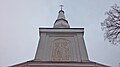 Sahryń wieża kościoła.jpg 2,560 × 1,440; 956 KB


