Category:Church in Tornow (Göritz)
Jump to navigation
Jump to search
| Object location | | View all coordinates using: OpenStreetMap |
|---|
church building in Brandenburg state, Germany _2018_SW.jpg) | |||||
| Upload media | |||||
| Instance of | |||||
|---|---|---|---|---|---|
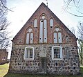
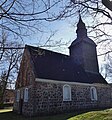
| Location | Tornow, Göritz, Uckermark District, Brandenburg, Germany | ||||
| Heritage designation | |||||
 | |||||
This is the category of the Brandenburger Baudenkmal (cultural heritage monument) with the ID 09130052 (Wikidata)
|
English: Pictures of the church in Tornow, Göritz municipality, Uckermark district, Brandenburg state, Germany
Deutsch: Bilder der Kirche in Tornow, Gemeinde Göritz, Landkreis Uckermark, Land Brandenburg, Deutschland.
Français : Photos de l'église à Tornow, commune de Göritz, arrondissement de Uckermark, état fédéral de Brandebourg, Allemagne
Media in category "Church in Tornow (Göritz)"
The following 10 files are in this category, out of 10 total.
-
 Dorfkirche Tornow (Göritz) 2018 E.jpg 5,264 × 4,857; 10.39 MB
-
 Dorfkirche Tornow (Göritz) 2018 ESE.jpg 4,079 × 4,808; 8.45 MB
-
 Dorfkirche Tornow (Göritz) 2018 N.jpg 3,526 × 4,776; 7.32 MB
-
 Dorfkirche Tornow (Göritz) 2018 NE.jpg 4,431 × 4,766; 9.69 MB
-
 Dorfkirche Tornow (Göritz) 2018 Portal.jpg 4,822 × 3,590; 8.93 MB
-
 Dorfkirche Tornow (Göritz) 2018 S.jpg 4,864 × 3,648; 9.85 MB
-
 Dorfkirche Tornow (Göritz) 2018 SE.jpg 3,648 × 4,864; 7.94 MB
-
 Dorfkirche Tornow (Göritz) 2018 SW.jpg 3,648 × 4,864; 6.8 MB
-
 Dorfkirche Tornow (Göritz) 2018 Turm SW.jpg 3,648 × 4,864; 7.55 MB
-
 Dorfkirche und Friedhof Tornow (Göritz) 2018.jpg 2,688 × 1,520; 2.84 MB
_2018_E.jpg)
_2018_ESE.jpg)
_2018_N.jpg)
_2018_NE.jpg)
_2018_Portal.jpg)
_2018_S.jpg)
_2018_SE.jpg)
_2018_Turm_SW.jpg)
_2018.jpg)