Category:Church in Wollschow
Jump to navigation
Jump to search
| Object location | | View all coordinates using: OpenStreetMap |
|---|
 | |||||
| Upload media | |||||
| Instance of | |||||
|---|---|---|---|---|---|
| Location | Wollschow, Brüssow, Amt Brüssow, Uckermark District, Brandenburg, Germany | ||||
| Heritage designation | |||||
 | |||||
This is the category of the Brandenburger Baudenkmal (cultural heritage monument) with the ID 09130205 (Wikidata)
|
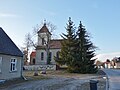
English: Pictures of the church in Wollschow, Brüssow municipality, Uckermark district, Brandenburg state, Germany
Deutsch: Bilder der Kirche in Wollschow, Stadt Brüssow, Landkreis Uckermark, Land Brandenburg, Deutschland.
Français : Photos de l'église à Wollschow, ville de Brüssow, arrondissement de Uckermark, état fédéral de Brandebourg, Allemagne
Media in category "Church in Wollschow"
The following 8 files are in this category, out of 8 total.
-
 Dorfkirche Wollschow 2018 N.jpg 5,438 × 4,814; 10.45 MB
-
 Dorfkirche Wollschow 2018 NE.jpg 3,648 × 4,864; 8 MB
-
 Dorfkirche Wollschow 2018 NW.jpg 4,354 × 4,707; 8.27 MB
-
 Dorfkirche Wollschow 2018 Portal.jpg 3,648 × 4,864; 6.65 MB
-
 Dorfkirche Wollschow 2018 S.jpg 4,864 × 3,648; 6.59 MB
-
 Dorfkirche Wollschow 2018 SE.jpg 4,864 × 3,648; 7.68 MB
-
 Dorfkirche Wollschow 2018 SW.jpg 4,392 × 4,811; 7.8 MB
-
 Dorfkirche Wollschow 2018 Turm.jpg 4,864 × 3,648; 5.39 MB


