Category:Church of Saint Bartholomew (Hniezdne)
Jump to navigation
Jump to search
| This category shows the protected monument with the number 710-872/1 (other) in the Slovak Republic. |
| Camera location | | View all coordinates using: OpenStreetMap |
|---|
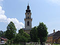
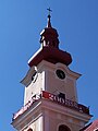
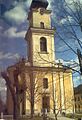
Slovenčina: Rímskokatolícky farský Kostol svätého Bartolomeja. Klasicistická sakrálna stavba postavená v rokoch 1802 - 1820
Media in category "Church of Saint Bartholomew (Hniezdne)"
The following 7 files are in this category, out of 7 total.
-
 Hniezdne GL1.jpg 2,255 × 1,692; 989 KB
-
 Hniezdne kirche.JPG 2,048 × 1,536; 711 KB
-
 Hniezdne kostol 01.jpg 3,000 × 4,000; 1.38 MB
-
 Hniezdne kostol 02.jpg 3,000 × 4,000; 1.81 MB
-
 Hniezdne kostol 03.jpg 3,000 × 4,000; 2.55 MB
-
 Hniezdne kostol 04.jpg 3,000 × 4,000; 1.04 MB
-
 Hniezdne.jpg 861 × 1,260; 353 KB


