Category:Cobridge
Ir a la navegación
Ir a la búsqueda
English: Cobridge is an area of Stoke-on-Trent in the county of Staffordshire, England. Cobridge has a Holdcroft (car dealer) centre on Sneyd Street, a community centre and a C of E church called Christ Church on Emery Street which is Grade II listed. Cobridge once had a railway station on the Potteries Loop Line. Cobridge was marked on the 1775 Yates map as 'Cow Bridge' and was recorded in Ward records (1843) as Cobridge Gate. There was once an old school house in Cobridge, at the bottom of Sneyd Street and demolished in 1897. A Victorian school once stood adjacent to Christ Church on the corner of Emery and Mawdesley Streets. The old Granville school was replaced by the new Forest Park school. St. Peter's Catholic school still exists in the area.
Scots: Cobridge is a aurie o Stoke-on-Trent in the coonty o Staffordshire, Ingland. Cobridge haes a Holdcroft (caur dealer) centre on Sneyd Street, a community centre an a C of E kirk cried Christ Church on Emery Street which is Grade II leetit. Cobridge ance haed a railwey station on the Potteries Loop Line. Cobridge wis markit on the 1775 Yates map as 'Cow Bridge' an wis recordit in Ward records (1843) as Cobridge Gate. Thare wis ance a auld schuil hoose in Cobridge, at the bottom o Sneyd Street an demolished in 1897. A Victorian schuil ance stuid adjacent tae Christ Church on the corner o Emery an Mawdesley Streets. The auld Granville schuil wis replacit bi the new Forest Park schuil. St. Peter's Catholic schuil still exists in the aurie.
Svenska: miniatyr
human settlement in United Kingdom  | |||||
| Cargar multimedia | |||||
| Instancia de | |||||
|---|---|---|---|---|---|
| Ubicación | City of Stoke-on-Trent, Staffordshire, Midlands del Oeste, Inglaterra | ||||
 | |||||
Subcategorías
Esta categoría contiene las siguientes 4 subcategorías, de un total de 4.
C
- Christ Church, Cobridge (6 F)
- James & Ralph Clews (35 F)
R
- Ralph Stevenson and Williams (2 F)
S
- Sadler & Green (22 F)
Archivos multimedia en la categoría «Cobridge»
Los siguientes 101 archivos pertenecen a esta categoría, de un total de 101.
-
 202 Field Hospital, Cobridge.jpg 4608 × 3456; 3,41 MB
-
 89 Square.jpg 2438 × 2437; 994 kB
-
 B5050 North Road in Cobridge - geograph.org.uk - 5209160.jpg 3062 × 2296; 2,04 MB
-

-
 Bottle Kiln at Moorcroft Pottery, Burslem - geograph.org.uk - 5115437.jpg 1500 × 1003; 752 kB
-
 Burnt grassland in Central Forest Park - geograph.org.uk - 5882143.jpg 4032 × 3024; 4,61 MB
-
 Canal south of Burslem, Stoke-on-Trent - geograph.org.uk - 4227968.jpg 1280 × 750; 467 kB
-
 Central Forest Park - geograph.org.uk - 5882181.jpg 4032 × 3024; 3,7 MB
-
 Central Forest Park looking west - geograph.org.uk - 5142670.jpg 4896 × 3672; 3,12 MB
-
 Central Forest Park, scrubland - geograph.org.uk - 5142700.jpg 4896 × 3672; 3,52 MB
-
 Cobridge Community Health Centre - geograph.org.uk - 3561532.jpg 1600 × 1200; 491 kB
-
 Cobridge Community Health Centre - geograph.org.uk - 5139635.jpg 4800 × 2686; 1,97 MB
-
 Cobridge Community Health Centre - geograph.org.uk - 5139816.jpg 4421 × 3041; 2,42 MB
-
 Cobridge Community Multicultural Association - geograph.org.uk - 5135053.jpg 4482 × 3373; 2,94 MB
-
 Cobridge fish and chip shop - geograph.org.uk - 5139655.jpg 3672 × 3761; 2,32 MB
-
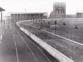 Cobridge Greyhound Stadium c.1950.png 920 × 695; 976 kB
-
 Cobridge Hall, Stoke-on-Trent.jpg 4608 × 3456; 3,49 MB
-
 Cobridge Industrial Estate - geograph.org.uk - 5141318.jpg 3672 × 4896; 4,8 MB
-
 Cobridge Park - geograph.org.uk - 5141208.jpg 4896 × 3672; 5,04 MB
-
 Cobridge Park - geograph.org.uk - 5141260.jpg 4896 × 3672; 3,01 MB
-
 Cobridge Park - geograph.org.uk - 5141266.jpg 4896 × 3672; 3,09 MB
-
 Cobridge site of station geograph-3311600-by-Ben-Brooksbank.jpg 2395 × 1537; 3,07 MB
-
 Cobridge, 342 Cobridge Road - geograph.org.uk - 5135133.jpg 3872 × 2758; 1,61 MB
-
 Cobridge, Britannia Business Park - geograph.org.uk - 5227208.jpg 3264 × 2448; 2,02 MB
-
 Cobridge, Church Terrace and the A53 - geograph.org.uk - 5136321.jpg 4845 × 3633; 3,15 MB
-
 Cobridge, cycleway off A53 - geograph.org.uk - 5142169.jpg 4896 × 3672; 3,96 MB
-
 Cobridge, cycleway off Sneyd Street - geograph.org.uk - 5142177.jpg 4896 × 3672; 3,81 MB
-
 Cobridge, demolition at the crossroads - geograph.org.uk - 5136297.jpg 4773 × 3117; 1,96 MB
-

-
 Cobridge, disused postbox on A53 - geograph.org.uk - 5135065.jpg 3672 × 4896; 4,7 MB
-
 Cobridge, former railway bridge beside the A53 - geograph.org.uk - 5141286.jpg 4896 × 3672; 4,27 MB
-
 Cobridge, former railway bridge beside the A53 - geograph.org.uk - 5141292.jpg 4896 × 3672; 4,65 MB
-
 Cobridge, Grange Street - geograph.org.uk - 5139779.jpg 4896 × 3672; 3 MB
-
 Cobridge, Grove Street - geograph.org.uk - 5141245.jpg 4896 × 3672; 2,99 MB
-
 Cobridge, Headway House - geograph.org.uk - 5139847.jpg 4103 × 2939; 2,27 MB
-

-
 Cobridge, Kia Motors - geograph.org.uk - 5134981.jpg 4418 × 2796; 2,11 MB
-
 Cobridge, Lindley Street - geograph.org.uk - 5209176.jpg 2796 × 2123; 1,91 MB
-
 Cobridge, Lloyds Pharmacy - geograph.org.uk - 5136331.jpg 4896 × 3672; 2,33 MB
-
 Cobridge, path behind Festival Heights - geograph.org.uk - 5134991.jpg 4896 × 3672; 3,09 MB
-
 Cobridge, Sneyd Street - geograph.org.uk - 5141308.jpg 4896 × 3672; 4,1 MB
-
 Cobridge, The Raven - geograph.org.uk - 5139732.jpg 4896 × 3672; 2,75 MB
-
 Cobridge, The Raven - geograph.org.uk - 5139744.jpg 4896 × 3672; 2,7 MB
-
 Crane Street, Cobridge - geograph.org.uk - 3560765.jpg 1600 × 1200; 543 kB
-
 Crossroads, Cobridge - geograph.org.uk - 3560806.jpg 1600 × 1200; 447 kB
-
 Crossroads, Cobridge - geograph.org.uk - 3560820.jpg 1600 × 1200; 434 kB
-
 Cycleway off the A50 Waterloo Road in Stoke - geograph.org.uk - 5142759.jpg 4896 × 3672; 4,34 MB
-
 Cycleway on Central Forest Park - geograph.org.uk - 5142641.jpg 4896 × 3672; 5,26 MB
-
 Cycleway on Central Forest Park - geograph.org.uk - 5142713.jpg 4896 × 3672; 3,42 MB
-
 Cycleway on Central Forest Park - geograph.org.uk - 5142726.jpg 4896 × 3672; 4,18 MB
-

-
 Disused building on Waterloo Road, Cobridge.jpg 4608 × 3456; 3,34 MB
-
 Entering Sneyd Green on the A53 - geograph.org.uk - 5227211.jpg 3264 × 2448; 2,35 MB
-
 Entrance to Cobridge Park - geograph.org.uk - 5139837.jpg 4896 × 3672; 5,11 MB
-
 Festival Heights entrance - geograph.org.uk - 5133969.jpg 4896 × 3672; 2,78 MB
-
 Festival Heights sign on A53 - geograph.org.uk - 5134904.jpg 3462 × 4616; 3,39 MB
-
 Festival Heights, car park - geograph.org.uk - 5133955.jpg 4370 × 3372; 2,85 MB
-
 Festival Heights, John Baskeyfield memorial statue - geograph.org.uk - 5133987.jpg 4896 × 3672; 4,33 MB
-
 Festival Heights, KFC - geograph.org.uk - 5133963.jpg 4688 × 3345; 2,42 MB
-
 Festival Heights, roundabout - geograph.org.uk - 5133979.jpg 4896 × 3672; 2,9 MB
-
 Festival Park, paths and grassland - geograph.org.uk - 5133940.jpg 4896 × 3672; 3,97 MB
-
 Festival Park, public footpath joins Greyhound Way - geograph.org.uk - 5133951.jpg 4432 × 3324; 3,02 MB
-
 Football pitch on Central Forest Park - geograph.org.uk - 5142694.jpg 4896 × 3672; 3,12 MB
-
 Footpath off the A50 Waterloo Road in Stoke - geograph.org.uk - 5142756.jpg 3264 × 2448; 2,56 MB
-
 Garages behind Adkins Street, Cobridge - geograph.org.uk - 5207800.jpg 4496 × 3247; 5,24 MB
-
 Gateway to Festival Park - geograph.org.uk - 2719916.jpg 1500 × 1000; 248 kB
-
 Ghost advertisement, Cobridge - geograph.org.uk - 3629175.jpg 1600 × 1200; 478 kB
-
 Hanley, alley off Portland Street - geograph.org.uk - 5143665.jpg 2448 × 3264; 2,32 MB
-
 Hanley, footpath off the A50 - geograph.org.uk - 5143702.jpg 4896 × 3672; 4,88 MB
-
 Hanley, houses on Waterloo Road - geograph.org.uk - 5143633.jpg 3076 × 2252; 1,67 MB
-
 Honda car dealer, Elder Road - geograph.org.uk - 5570695.jpg 1600 × 1103; 569 kB
-
 Houses on the edge of Central Forest Park - geograph.org.uk - 5882175.jpg 4032 × 3024; 4,34 MB
-
 Installation on Central Forest Park - geograph.org.uk - 5142689.jpg 4896 × 3672; 4,08 MB
-
 John Baskeyfield memorial statue, Festival Park - geograph.org.uk - 6087091.jpg 2000 × 1500; 1,74 MB
-

-
 Lindley Street, Stoke on Trent - geograph.org.uk - 2191367.jpg 640 × 480; 64 kB
-
 Memorial at end of Sneyd Street, Cobridge - geograph.org.uk - 3561675.jpg 1200 × 1600; 775 kB
-
 Moorcroft Pottery - geograph.org.uk - 1814509.jpg 1500 × 975; 107 kB
-
 Moorcroft Pottery - geograph.org.uk - 5867573.jpg 1024 × 768; 232 kB
-
 Moorcroft Pottery - geograph.org.uk - 5867574.jpg 768 × 1024; 228 kB
-
 Moorcroft Pottery, Burslem - geograph.org.uk - 3631142.jpg 1600 × 1200; 404 kB
-
 Morcroft pottery hovel - geograph.org.uk - 6156227.jpg 656 × 709; 250 kB
-
 Morrisons supermarket in Stoke on Trent - geograph.org.uk - 2719915.jpg 1500 × 1000; 141 kB
-
 North Road, Burslem - geograph.org.uk - 3631184.jpg 1600 × 1200; 510 kB
-

-
 Outdoor equipment in Cobridge Park - geograph.org.uk - 5141236.jpg 4896 × 3672; 4,11 MB
-
 Outdoor table tennis facility in Cobridge Park - geograph.org.uk - 5141225.jpg 4896 × 3672; 5,21 MB
-
 Play area, Dryden Road - geograph.org.uk - 2797293.jpg 640 × 480; 69 kB
-
 Play area, Dryden Road - geograph.org.uk - 2797298.jpg 640 × 480; 74 kB
-
 Remer Street, Cobridge - geograph.org.uk - 3560940.jpg 1200 × 1600; 529 kB
-
 Renewable Energy Services, Cobridge Road - geograph.org.uk - 4907731.jpg 1200 × 903; 410 kB
-
 Shelton Bar Trigpoint - geograph.org.uk - 6153377.jpg 2000 × 1499; 3,55 MB
-

-
 Sneyd Green, semis on Leek New Road - geograph.org.uk - 5227213.jpg 3264 × 2448; 2,31 MB
-
 Sneyd Hill Park - geograph.org.uk - 5207792.jpg 3264 × 2448; 4,83 MB
-
 Sports court in Cobridge Park - geograph.org.uk - 5141214.jpg 4896 × 3672; 2,87 MB
-
 The Moorcroft Pottery Burslem - geograph.org.uk - 3701422.jpg 4352 × 3264; 3,83 MB
-
 The Raven on Elder Road - geograph.org.uk - 4907738.jpg 1200 × 986; 372 kB
-
 Warehouse, trade shop or box^ - geograph.org.uk - 5570688.jpg 1600 × 1196; 695 kB
-
 Works, Festival Way - geograph.org.uk - 2503323.jpg 606 × 640; 82 kB
-
 Works, Greyhound Way - geograph.org.uk - 2797287.jpg 640 × 480; 55 kB


_Drive_and_Cobridge_Road_-_geograph.org.uk_-_5133995.jpg)


