Category:Colorado State Highway 5
Jump to navigation
Jump to search
 | number: | (five) |
|---|---|---|
| State highways in Colorado: | 1 · 2 · 3 · 5 · 7 · 8 · 9 · 10 · 11 · 12 · 13 · 14 · 15 · 16 · 17 · 21 · 22 · 23 |
state highway in Clear Creek County, Colorado, United States   | |||||
| Upload media | |||||
| Instance of | |||||
|---|---|---|---|---|---|
| Location | Clear Creek County, Colorado | ||||
| Transport network | |||||
| Owned by | |||||
| Maintained by | |||||
| Inception |
| ||||
| Length |
| ||||
| Terminus | |||||
| |||||
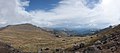
English: Media relatd to Colorado State Highway 5, a 14.89-mile (23.96 km) state highway in Clear Creek County, Colorado, United States, that connects the summit of Mount Evans with Colorado State Highway 103 and is the highest paved road in the United States. (While there is no charge to travel the road itself, any stopping along it requires a national forest pass. The highway is closed in the winter.)
Media in category "Colorado State Highway 5"
The following 22 files are in this category, out of 22 total.
-
 Colorado 5.svg 601 × 601; 4 KB
-
 Colorado 5 map.png 709 × 517; 36 KB
-
 2007-06-17-evans-road-morn-.jpg 880 × 241; 72 KB
-
 Colorado 5 (1926).svg 401 × 401; 8 KB
-
 Colorado 5 (1946).svg 401 × 401; 8 KB
-
 Colorado 5 (1952).svg 400 × 400; 6 KB
-
 EvansByway.jpg 1,296 × 976; 781 KB
-
 Mount Evans Road (1) (5925167534).jpg 5,553 × 2,128; 4.3 MB
-
 Mount Evans Road (2) (5924605821).jpg 6,414 × 4,319; 10.1 MB
-
 Mount Evans Road in a Thunderstorm (1) (5924608461).jpg 1,024 × 683; 66 KB
-
 Mount Evans Road in a Thunderstorm (2) (5925169636).jpg 1,024 × 683; 130 KB
-
 Mount Evans Road in a Thunderstorm (3) (5925169530).jpg 1,024 × 683; 177 KB
-
 Mount Evans Road in a Thunderstorm (4) (5925169280).jpg 2,376 × 1,584; 684 KB
-
 Mount Evans Road in a Thunderstorm (5) (5924607681).jpg 2,376 × 1,584; 840 KB
-
 Mount Evans Road in a Thunderstorm (6) (5925168060).jpg 2,376 × 1,584; 1.04 MB
-
 Mount Evans Road in a Thunderstorm (7) (5925167958).jpg 2,376 × 1,584; 929 KB
-
 Mt Evans Pan.jpg 7,633 × 2,113; 4.34 MB
-
 View From Mount Evans Road (1) (5924608173).jpg 1,024 × 683; 145 KB
-
 View From Mount Evans Road (2) (5924608009).jpg 5,470 × 2,350; 4.41 MB
-
 View From Mount Evans Road (3) (5925168152).jpg 4,395 × 1,547; 1.7 MB
-
 View From Mount Evans Road (4) (5924606503).jpg 4,934 × 2,159; 3.08 MB
-
 Welcome sign, Mount Evans byway.jpg 2,816 × 2,112; 2.72 MB
.svg)
.svg)
.svg)
_(5924605821).jpg)
_(5924608461).jpg)
_(5925169636).jpg)
_(5925169530).jpg)
_(5925169280).jpg)
_(5924607681).jpg)
_(5925168060).jpg)
_(5925167958).jpg)
_(5924608173).jpg)
_(5924608009).jpg)
_(5924606503).jpg)

_(5925167534).jpg)
_(5925168152).jpg)