Category:Cookson's Bridge pub, Ford
Jump to navigation
Jump to search
| Object location | | View all coordinates using: OpenStreetMap |
|---|
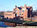
Pub handy for the Leeds and Liverpool canal in Ford. Formerly the Tailor's Arms and before that, a Coroner's Court.
Media in category "Cookson's Bridge pub, Ford"
The following 6 files are in this category, out of 6 total.
-
-
 Cookson's Bridge pub, Ford.jpg 5,100 × 3,327; 20.82 MB
-
 Cooksons Bridge pub, Gorsey Lane.jpg 4,608 × 3,456; 3.38 MB
-
 Cooksons Bridge public house - geograph.org.uk - 6136610.jpg 640 × 503; 108 KB
-
 Cooksons Bridge Public House - geograph.org.uk - 6186430.jpg 1,600 × 1,064; 441 KB
-
 Cooksons Bridge Public House - geograph.org.uk - 6186435.jpg 1,600 × 1,064; 601 KB


