Category:Cotehele Tower
Jump to navigation
Jump to search
| Object location | | View all coordinates using: OpenStreetMap |
|---|
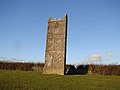
folly on the Cotehele Estate in Calstock, Cornwall, England, UK  | |||||
| Upload media | |||||
| Instance of |
| ||||
|---|---|---|---|---|---|
| Location | Calstock, Cornwall, South West England, England | ||||
| Heritage designation |
| ||||
 | |||||
Media in category "Cotehele Tower"
The following 5 files are in this category, out of 5 total.
-
 Barley field near Cotehele - geograph.org.uk - 195993.jpg 640 × 480; 96 KB
-
 Cotehele Tower - geograph.org.uk - 1074671.jpg 640 × 480; 52 KB
-

-
 Prospect Tower, Cotehele - panoramio.jpg 1,200 × 1,600; 265 KB
-
 View from Cotehele prospect tower - geograph.org.uk - 813423.jpg 640 × 480; 58 KB


