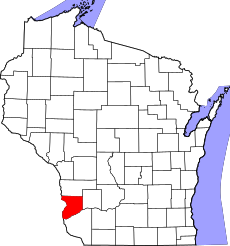
Category:Crawford County, Wisconsin
Jump to navigation
Jump to search
Counties of Wisconsin: Adams · Ashland · Barron · Bayfield · Brown · Buffalo · Burnett · Calumet · Chippewa · Clark · Columbia · Crawford · Dane · Dodge · Door · Douglas · Dunn · Eau Claire · Florence · Fond du Lac · Forest · Grant · Green · Green Lake · Iowa · Iron · Jackson · Jefferson · Juneau · Kenosha · Kewaunee · La Crosse · Lafayette · Langlade · Lincoln · Manitowoc · Marathon · Marinette · Marquette · Menominee · Milwaukee · Monroe · Oconto · Oneida · Outagamie · Ozaukee · Pepin · Pierce · Polk · Portage · Price · Racine · Richland · Rock · Rusk · Sauk · Sawyer · Shawano · Sheboygan · St. Croix · Taylor · Trempealeau · Vernon · Vilas · Walworth · Washburn · Washington · Waukesha · Waupaca · Waushara · Winnebago · Wood
county in Wisconsin, United States | |||||
| Upload media | |||||
| Instance of | |||||
|---|---|---|---|---|---|
| Named after | |||||
| Location | Wisconsin | ||||
| Capital | |||||
| Inception |
| ||||
| Population |
| ||||
| Area |
| ||||
| Different from | |||||
| official website | |||||
 | |||||
English: Media related to Crawford County, Wisconsin, a county in Wisconsin, United States.
Subcategories
This category has the following 11 subcategories, out of 11 total.
F
H
K
M
N
P
T
Media in category "Crawford County, Wisconsin"
The following 48 files are in this category, out of 48 total.
-
Apple Orchard - panoramio.jpg 4,000 × 3,000; 3.33 MB
-
Apple Trees - panoramio (4).jpg 4,000 × 3,000; 2.82 MB
-
Apple Trees - panoramio (5).jpg 4,000 × 3,000; 4.1 MB
-
ATC Power Line - panoramio (152).jpg 5,184 × 3,888; 4.96 MB
-
ATC Power Line - panoramio (153).jpg 5,184 × 3,888; 4.4 MB
-
ATC Power Lines - panoramio (87).jpg 5,184 × 3,888; 6.3 MB
-
Barnum, WI from the south.JPG 4,000 × 3,000; 3.01 MB
-
Bridge over the Kickapoo River - panoramio.jpg 3,985 × 2,602; 2 MB
-
Bridge Over The Wisconsin River - panoramio.jpg 4,565 × 2,082; 3.05 MB
-
Bridgeport Wisconsin Sign WIS60.jpg 2,736 × 1,824; 2.16 MB
-
Crawford County Fairgrounds - panoramio.jpg 4,000 × 3,000; 2.51 MB
-
Crawford County Fairgrounds Grandstand - panoramio.jpg 4,000 × 3,000; 2.65 MB
-
Crawford County Wisconsin Sign WIS60.jpg 2,736 × 1,824; 2.41 MB
-
Eastman, WI post office.jpg 6,000 × 4,000; 5.18 MB
-
Ferryville, Wisconsin.jpg 4,000 × 3,000; 9.91 MB
-
H Frame Power Line Poles - panoramio.jpg 4,608 × 3,456; 8.2 MB
-
Hillcrest Orchard ^ Christmas Tree Farm - panoramio.jpg 3,859 × 2,470; 4.77 MB
-
Lock and Dam 9 - panoramio.jpg 2,543 × 1,727; 1.57 MB
-
Lynxville, Wisconsin-1.jpg 4,000 × 3,000; 8.9 MB
-
Lynxville, Wisconsin-2.jpg 5,989 × 4,064; 17.98 MB
-
Mississippi River Bluffs (Lansing, Iowa) (26349419875).jpg 5,318 × 3,210; 17.43 MB
-
Mt. Zion, Wisconsin.jpg 3,976 × 2,966; 10.07 MB
-
Power Line - panoramio (2).jpg 4,000 × 3,000; 2.48 MB
-
Power Line Crossing The WI River - panoramio.jpg 4,608 × 3,456; 5.7 MB
-
Prairie du Chien baseball fields.jpg 4,000 × 3,000; 8.21 MB
-
Prairie du Chien High School.jpg 3,944 × 2,773; 8.29 MB
-
Prairie du Chien skyline.jpg 7,794 × 2,560; 10.43 MB
-
Prairie du Chien, Wisconsin.jpg 5,054 × 3,076; 10.04 MB
-
Rock Cut - panoramio (1).jpg 4,608 × 3,456; 12.23 MB
-
Rolling Ground Cell Tower - panoramio.jpg 3,939 × 2,740; 1.52 MB
-
Rolling Ground, Wisconsin.jpg 3,893 × 3,503; 9.67 MB
-
SMRT Buses in winter.jpg 4,898 × 3,265; 877 KB
-
Soldiers Grove Communication Tower - panoramio.jpg 4,896 × 3,672; 7.28 MB
-
Soldiers Grove, Wisconsin.jpg 4,000 × 3,000; 7.98 MB
-
Steuben Village Center - panoramio.jpg 4,796 × 2,467; 3.32 MB
-
Sunrise Orchards Apple Trees - panoramio.jpg 4,896 × 3,672; 5.39 MB
-
Tainter Cave pictograph.jpg 1,206 × 1,329; 152 KB
-
The Nina - panoramio.jpg 1,024 × 768; 316 KB
-
Totem Pole - panoramio (1).jpg 3,672 × 4,896; 5.72 MB
-
Towerville.jpg 3,860 × 2,796; 7.99 MB
-
Town of Clayton, Wisconsin.jpg 4,000 × 3,000; 7.77 MB
-
Two Silos near Eastman - panoramio.jpg 4,896 × 3,672; 4.19 MB
-
Udder Family Farm - panoramio.jpg 4,267 × 3,028; 8.52 MB
-
US-18 & Wis-35 in Prairie du Chien.jpg 4,000 × 3,000; 6.35 MB
-
USA Crawford County, Wisconsin age pyramid.svg 520 × 600; 8 KB
-
Utilization Research - General - DPLA - 0dcaa33aeadd11cc7b12f732081d093d.jpg 2,754 × 3,967; 1.15 MB
-
Wyalusing Academy - panoramio (2).jpg 3,206 × 1,580; 527 KB
-
Wyalusing Academy overhead river 01.jpg 2,048 × 1,397; 671 KB


