Category:Creek Turnpike
Jump to navigation
Jump to search
 | number: | (three hundred sixty-four) |
|---|---|---|
| State highways in Oklahoma: | 364 |
state highway toll road in Oklahoma, United States    | |||||
| Upload media | |||||
| Instance of | |||||
|---|---|---|---|---|---|
| Named after | |||||
| Location |
| ||||
| Transport network |
| ||||
| Owned by |
| ||||
| Maintained by |
| ||||
| Start time |
| ||||
| Inception |
| ||||
| Length |
| ||||
| Terminus | |||||
| |||||
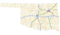
English: Media related to Creek Turnpike (Oklahoma State Highway 364), a 33.22-mile (53.46 km) state highway toll road in Oklahoma, United States, that connects Interstate 44/Turner Turnpike on the border of Sapulpa with U.S. Route 412/Will Rodgers Turnpike on the border of Tulsa and Fair Oaks.
Subcategories
This category has only the following subcategory.
Media in category "Creek Turnpike"
The following 8 files are in this category, out of 8 total.
-
 Creek East plaza apch.jpg 2,048 × 1,536; 538 KB
-
 Creek East Plaza.jpg 2,048 × 1,536; 520 KB
-
 Creek Tpk Exit 31.jpg 1,600 × 1,200; 345 KB
-
 Creek Turnpike OSM.png 1,417 × 821; 924 KB
-
 Creek Turnpike path.png 3,264 × 1,920; 1.13 MB
-
 Creek Turnpike.svg 600 × 600; 15 KB
-
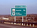 I-44 OK exits 218A-B.jpg 1,021 × 766; 925 KB
-
 Oklahoma State Highway 364.svg 480 × 385; 9 KB


