Category:Creu de terme de Boldú
Jump to navigation
Jump to search
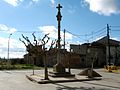
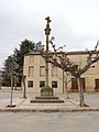
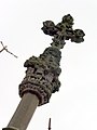
Català: Creu de terme de Boldú (la Fuliola)
This is a category about a building listed in the Catalan heritage register as Bé Cultural d'Interès Local (BCIL) under the reference IPA-29769. |
| Object location | | View all coordinates using: OpenStreetMap |
|---|
 | |||||
| Upload media | |||||
| Instance of | |||||
|---|---|---|---|---|---|
| Part of | |||||
| Location | La Fuliola, Urgell, Ponent, Lleida Province, Catalonia | ||||
| Street address |
| ||||
| Architectural style | |||||
| Heritage designation |
| ||||
| Inception |
| ||||
| Elevation above sea level |
| ||||
 | |||||
Subcategories
This category has only the following subcategory.
Media in category "Creu de terme de Boldú"
The following 6 files are in this category, out of 6 total.
-
 Creu de terme de Boldú (La Fuliola).jpg 800 × 600; 374 KB
-
 CREU DE TERME DE BOLDÚ - IB-480.jpg 1,536 × 2,048; 928 KB
-
 CREU DE TERME DE BOLDÚ - IB-482.jpg 1,536 × 2,048; 1.09 MB
-
 CREU DE TERME DE BOLDÚ - IB-483.jpg 2,048 × 1,536; 1,014 KB
-
 CREU DE TERME DE BOLDÚ - IB-485.jpg 1,536 × 2,048; 1.12 MB
-
 Plaça de la Creu, Boldú, la Fuliola.jpg 6,000 × 4,000; 6.71 MB
.jpg)


