Category:Creu de terme de Pinós
Jump to navigation
Jump to search
| Object location | | View all coordinates using: OpenStreetMap |
|---|
 | |||||
| Upload media | |||||
| Instance of | |||||
|---|---|---|---|---|---|
| Location | Pinós, Solsonès, Lleida Province, Ugwuoba | ||||
| Architectural style | |||||
| Heritage designation |
| ||||
| Elevation above sea level |
| ||||
 | |||||
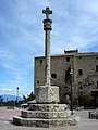
Català: Creu de terme del Santuari de Pinós (Solsonès), a la carena de la serra homònima.
This is a category about a building listed in the Catalan heritage register as Bé Cultural d'Interès Local (BCIL) under the reference IPA-17544. |
Media in category "Creu de terme de Pinós"
The following 5 files are in this category, out of 5 total.
-
 CREU DE TERME - PINÓS - IB-188.JPG 1,536 × 2,048; 1.64 MB
-
 CREU DE TERME - PINÓS.JPG 1,536 × 2,048; 1.69 MB
-
 Creu i santuari de Pinós de Solsonès.jpeg 1,574 × 720; 136 KB
-
 Pinós, Sanctuario-PM 64986.jpg 667 × 1,000; 456 KB
-
 Pinós, Sanctuario-PM 64987.jpg 477 × 1,000; 329 KB


